
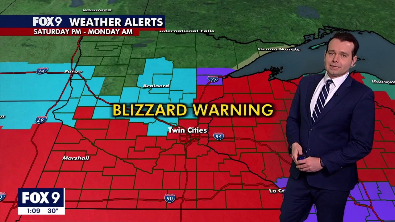
MINNEAPOLIS (FOX 9) – A blizzard warning remains in effect Sunday, as snow continues to fall across much of Minnesota. Hundreds of crashes have been reported as road conditions deteriorate. Meanwhile, hundreds of flights have also been canceled.
Watch FOX 9 live in the player above, and find live updates below. Download the FOX 9 Weather app for location-based alerts.
What to expect:
Heavy snow has developed across southern Minnesota and is expected to expand into western Wisconsin Sunday morning. Winds are expected to increase, with widespread blowing snow and blizzard conditions Sunday afternoon and Sunday night. Snowfall rates of 2–3 inches per hour are possible through mid-morning. Snow is expected to taper off from northwest to southeast Sunday afternoon and evening.
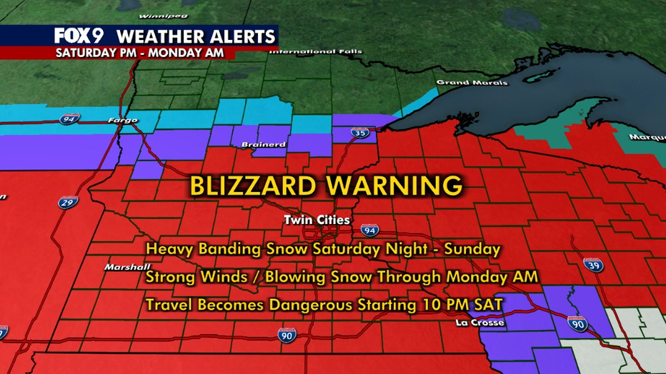
Driving conditions are expected to deteriorate Sunday and dangerous conditions could continue through Monday. Even though the snow is expected to taper off gradually on Sunday, northwest winds will increase, which could reduce visibility and create blizzard conditions into Sunday night.
Why you should care:
Dangerous to impossible driving conditions are possible Sunday afternoon. Difficult driving conditions could continue into Monday.
RELATED:
6 p.m. – MnDOT closing highways in southern Minnesota
Officials with MnDOT say several state highways and Interstate 90 in south Central Minnesota are closing at 6 p.m. Sunday. Snow and strong winds are creating blowing and drifting snow, significantly reducing visibility and creating hazardous travel conditions. Here is a list of the closures:
All state highways in Nobles, Jackson, Cottonwood, Watonwan, Martin, and Faribault countiesI-90 from Albert Lea to WorthingtonEastbound I-90 from the South Dakota border to Worthington will remain openWestbound I-90 from Adrian to the South Dakota border will remain openWestbound I-90 from Worthington to Adrian will be closedEastbound I-90 from the South Dakota border to Worthington will remain openWestbound I-90 from Adrian to the South Dakota border will remain openWestbound I-90 from Worthington to Adrian will be closedHighway 60 from Iowa to MankatoHighway 15 from Iowa to Highway 19
The road closures are expected to remain overnight and until conditions gradually improve on Monday. South Central Minnesota remains in a Blizzard Warning until Monday morning. MnDOT reminds motorists that it is illegal to travel on a closed road and if a motorist requires rescuing, they are liable for all related rescue costs.
A no travel advisory remains on state highways in the following counties: Rock, Sibley, Nicollet, Le Sueur, Waseca, Brown, and Blue Earth.
5:30 p.m. – Minneapolis closing elementary schools Monday, St. Paul Schools closed
Officials with Minneapolis Public Schools are declaring a severe weather day for the district on Monday after our weekend blizzard.
Officials with Minneapolis Public Schools say due to our weekend winter storm, there will be no school for elementary (Pre-K through fifth grade) on Monday. MPS officials say students in middle school and high school will have an e-learning day.
All MPS-sponsored programs and after-school activities, including adult education, will also be canceled.
Officials with St. Paul Public schools say there will be no classes on Monday. Students should not report to school, and it will not be an E-learning day. District officials say classes are canceled.
Discovery Club and Adult Basic Education will be closed. All other athletic events and after-school activities will be canceled, with exceptions made on a case-by-case basis.
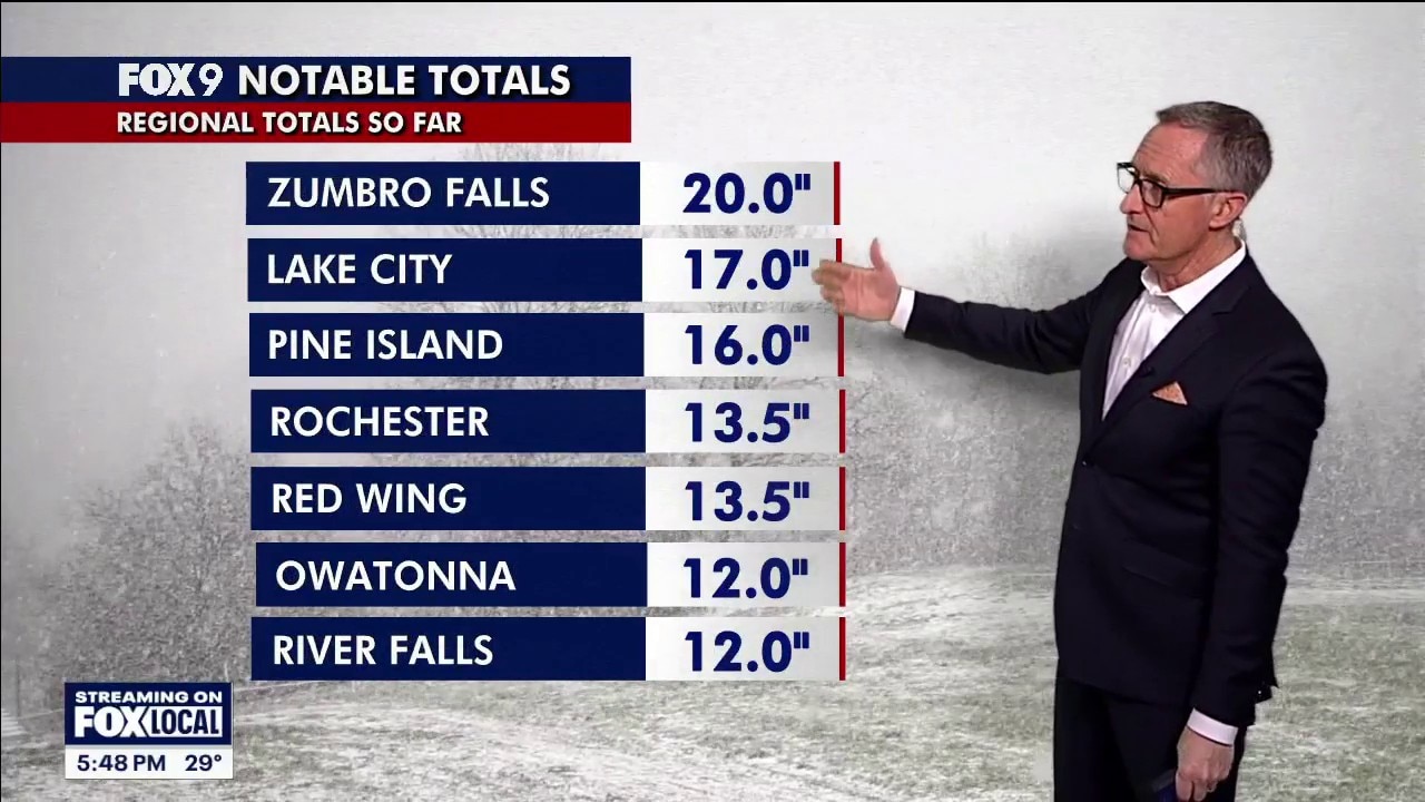
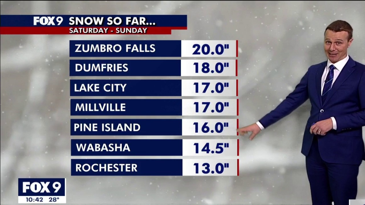
4 p.m. – Sunday afternoon snow totals 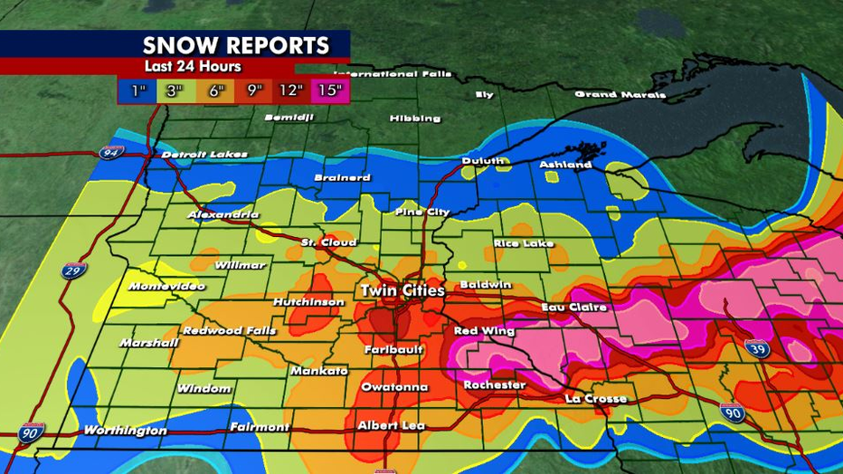
Here’s a look at updated snow totals from our weekend blizzard:
Prior Lake: 13.7 inchesApple Valley: 13.2 inchesStillwater: 11 inchesCarver: 11 inchesEagan: 11 inchesMaple Grove: 10 inchesCottage Grove: 10 inches 2:45 p.m. – Travel not advised across most of Wisconsin
In an update Sunday afternoon, the Wisconsin Department of Transportation announced travel was not advised across much of the state due to the snow storm.
WisDOT is urging most residents to limit travel to emergencies.
Travel is not advised in the following Wisconsin counties:
Northeast Region (11 counties: Brown, Calumet, Door, Fond du Lac, Kewaunee, Manitowoc, Marinette, Oconto, Outagamie, Sheboygan, and Winnebago)North Central Region (18 counties: Adams, Florence, Forest, Green Lake, Iron, Langlade, Lincoln, Marathon, Marquette, Menominee, Oneida, Portage, Price, Shawano, Vilas, Waupaca, Waushara, and Wood)Northwest Region (20 counties: Ashland, Barron, Bayfield, Buffalo, Burnett, Chippewa, Clark, Douglas, Dunn, Eau Claire, Jackson, Pepin, Pierce, Polk, Rusk, Sawyer, St. Croix, Taylor, Trempealeau, and Washburn) 1 p.m. – Wind and snow expected to make a mess in the afternoon
Reduced visibility is still a factor on Sunday afternoon as strong winds bring blowing snow into Minnesota.
Final snowfall totals are still being counted as the storm continues.
Heavy and dense snow fell in the morning, with light and fluffy snow falling through the afternoon.
 11 a.m. – Snowfall totals rise across Minnesota
Snow totals reports continue to rise across Minnesota as the winter storm turns into a full-fledged blizzard.
Impressive snow totals are concentrated in the southeast corner of the state.
 10:30 a.m. – I-35 to close near Albert Lea at 3 p.m.
MnDOT will close the southbound lanes of I-35 at Albert Lea by 3 p.m. on Sunday, when Iowa plans to close I-35 south at that time.
State officials say they will keep the southbound lanes of the highway closed until the highway reopens in Iowa.
This is in addition to the no-travel advisory already in place for southeast Minnesota and other travel warnings issued for state highways west of District 6 in southern Minnesota.
Snowplows remain on the roads, but are having difficulty keeping up with the current rate of snowfall.
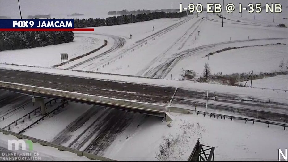
Image shows a snow-covered Interstate 35 in Minnesota. (Supplied)
9:50 a.m. – MSP Airport a ‘ghost town’ 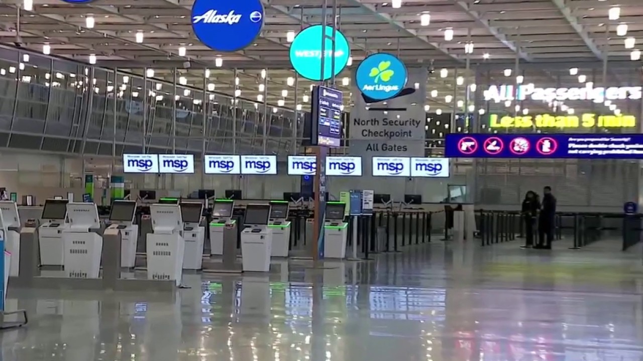
Hundreds of flights have been canceled at MSP Airport, with FOX 9’s Mike Manzoni reports that MSP is “effectively shut down” and flight cancellations continue to rise.
More than 626 flight cancellations have been reported at MSP as of Sunday morning.
9:18 a.m. – State Patrol’s tips if you go off the road  Minnesota State Patrol urges drivers to stay off roads
The Minnesota State Patrol’s Lt. Mike Lee says people should stay off the roads. But if you have to travel, and if you go off the road, you should stay in your vehicle, keep your seatbelt on, and do anything you can to make yourself more visible, like turn on your flashers.
The Minnesota State Patrol’s Lt. Mike Lee says if you go off the road, you should stay in your vehicle, keep your seatbelt on, and do anything you can to make yourself more visible, like turn on your flashers.
Watch the full interview above.
9 a.m. – Snow covered roads
Strong winds and snow continue to bring blizzard conditions to much of Minnesota. Many roads are completely covered with ice and snow, and parts of southern Minnesota are in a no-travel advised status, the National Weather Service says.
Find the latest road conditions here.
8:43 a.m. – Latest crash numbers
The Minnesota State Patrol says from 6:30-8:30 a.m. there have been 11 property damage crashes, three spin outs, 84 vehicles off the road and one jackknifed semi-truck.
The State Patrol is asking people to “delay or cancel travel plans until the storm has passed and road conditions improve.”
Earlier, from midnight to 6:30 a.m., the Minnesota State Patrol said there were 21 property damage crashes, one injury crash, five spin outs, 70 vehicles off the road and six jackknifed semi-trucks.
8:40 a.m. – ‘Civil danger warning’ 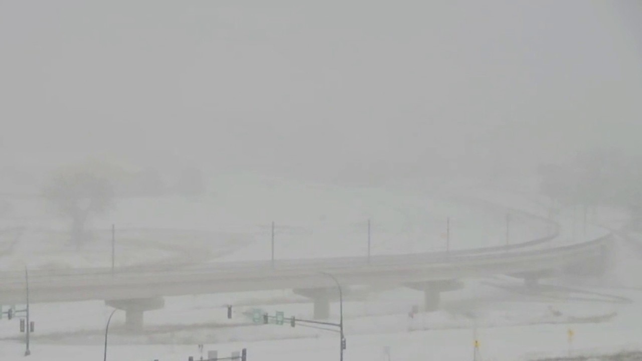 ‘Civil danger warning’ in MN county
At 8:14 a.m. on Sunday, the Minnesota Rice/Steele County 911 center posted a “civil danger warning,” according to the National Weather Service. According to the warning, “non-essential personnel please STAY OFF ROADS to ensure your safety. Current road conditions pose significant risks to drivers and pedestrians. Crews are at work restoring roads to safe conditions.”
At 8:14 a.m. on Sunday, the Minnesota Rice/Steele County 911 center posted a “civil danger warning,” according to the National Weather Service.
According to the warning, “non-essential personnel please STAY OFF ROADS to ensure your safety. Current road conditions pose significant risks to drivers and pedestrians. Crews are at work restoring roads to safe conditions.”
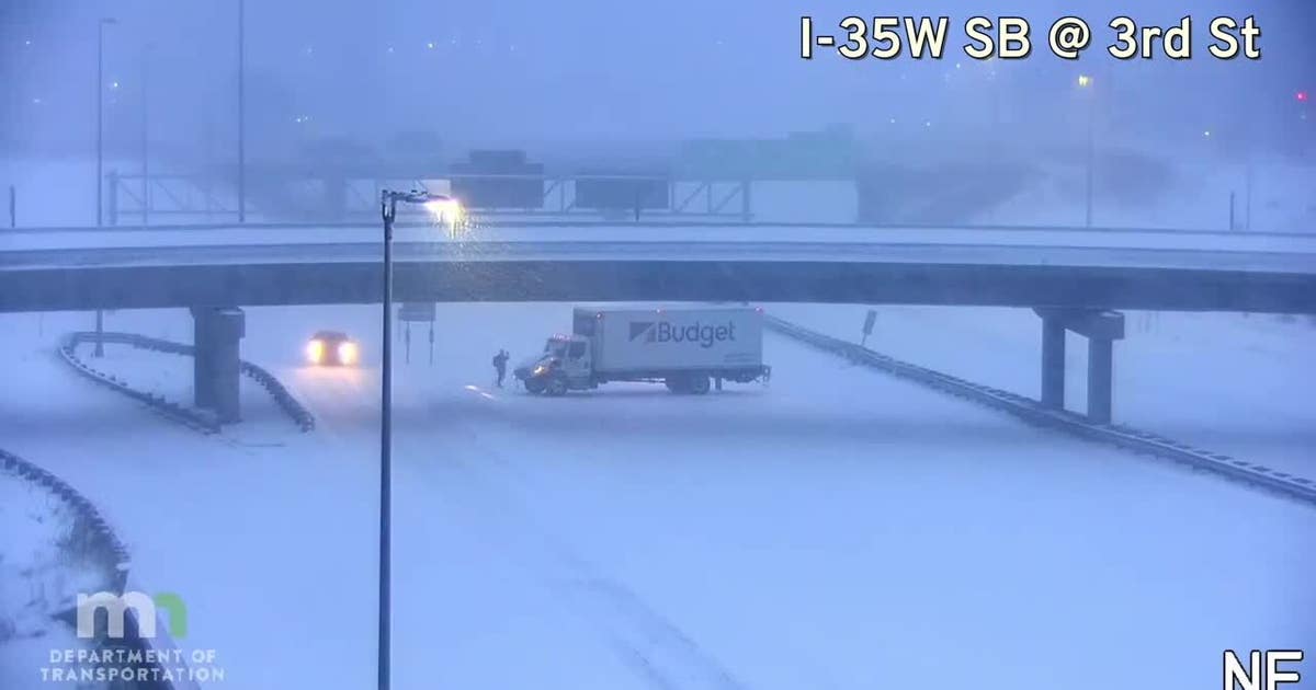
8:30 a.m. – Snow covered roads causing problems
Several incidents have been reported on Minnesota roads Sunday morning in the Twin Cities, where roads are completely covered in snow. One example is a vehicle stuck on U.S. Highway 12 – they’re stuck in the middle of a lane of traffic, and have been stuck for more than 30 minutes.
Find the latest road conditions here.
8 a.m. – No travel advised in much of southern MN 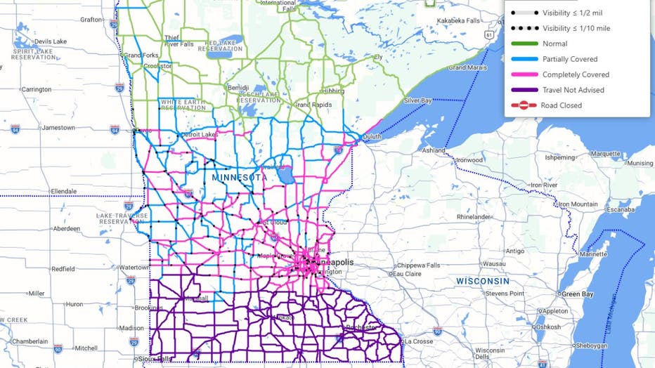
Road conditions across Minnesota as of 8:15 a.m. on March 15, 2026. (MnDOT)
No travel is advised in most of southern Minnesota, south of the Twin Cities metro.
MnDOT is advising no travel due to blowing snow and reduced visibility. Motorists are advised to not drive until conditions improve.
Winds are expected to increase Sunday afternoon, which could lead to more blowing snow.
7:50 a.m. – Winds will increase this afternoon
Snow continues today with more accumulations possible, especially in southeastern Minnesota. Winds will increase into this afternoon, causing blowing snow and white-out conditions. Travel is expected to get worse – and could be nearly impossible.
7:30 a.m. – Roads completely covered in snow 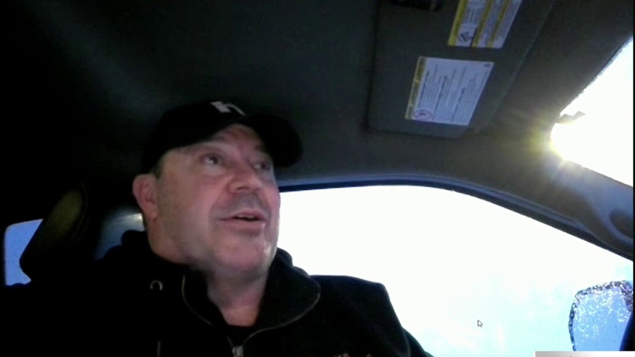
Sixty plows are out in Hennepin County to clear roads, but snow is falling and blowing around, so work the plows are doing is quickly getting undone.
Andy Kraemer, who is in charge of plows at Hennepin County, gave tips on how to stay safe on the roads while crews work overtime to clear snow, including staying 10 car lengths away from plows and if you see the driver’s face in the mirror, they can see you. He also suggests staying home if you can.
Some plow drivers started their shifts late Saturday night as the snow shows no sign of slowing down.
7 a.m. – Sleet, ice balls and thunder 
The Winona County Sheriff’s Office posted on social media Sunday morning, saying “We have now added sleet, little ice balls, thunder and lightning to this mess. Roads will be good for small stints and then the road disappears completely and your car is doing its best downhill ski mogul impression. So far, this storm has been ‘as advertised.’ Please drive safe, if you have to drive at all.”
6:50 a.m. – Hundreds of flights canceled at MSP Airport 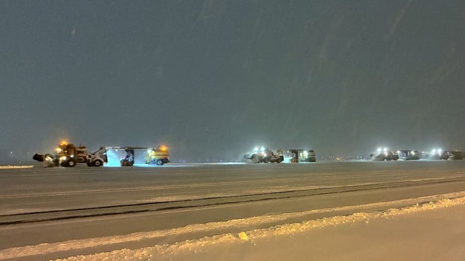
Plows at MSP Airport on Sunday, March 15, 2026.
MSP Airport posted on social media to say more than 450 flights to and from MSP have been canceled on Sunday.
Check with your airline for the latest flight information.
Major airlines did issue waivers ahead of the winter storm.
6:48 a.m. – Updated crash numbers
From midnight to 6:30 a.m., the Minnesota State Patrol says there were 21 property damage crashes, one injury crash, five spin outs, 70 vehicles off the road and six jackknifed semi-trucks.
6:43 a.m. – No travel advised in much of southern MN 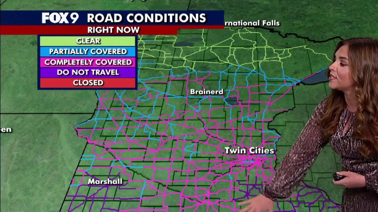
The Minnesota Department of Transportation is advising no travel on highways and I-90 in south-central Minnesota starting at 7 a.m. Sunday, noting blowing snow and strong winds are creating blizzard conditions and are making travel difficult.
A no travel advisory has also been issued for a portion of southeast Minnesota, from Faribualt and Owatonna, east to Rochester and Winona areas.
No travel is also advised in southwest Minnesota, near Pipestone and Marshall.
6:22 a.m. – Travel expected to get worse Sunday 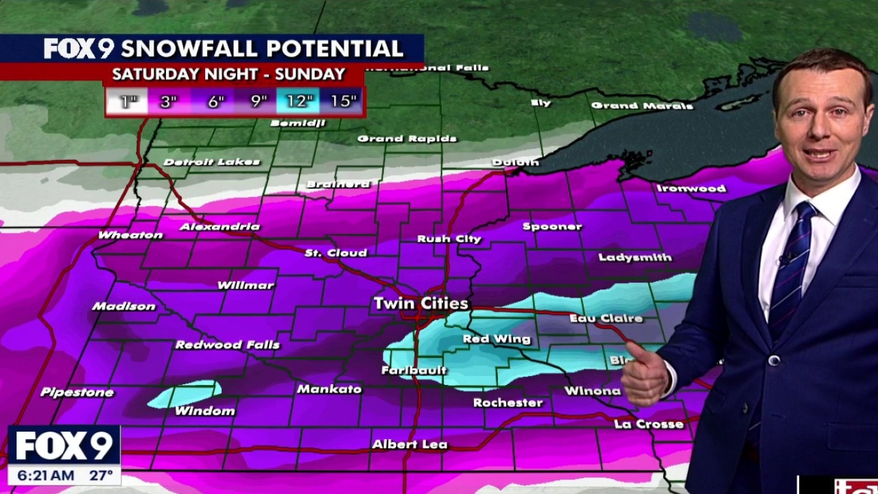
Wind will pick up by mid-morning and will stay strong the rest of the day, which will make travel much worse — especially in open areas, according to FOX 9’s Jared Piepenburg.
6 a.m. – Snow totals so far
Here’s a look at how much snow has fallen so far:
Elko New Market: 8 inchesApple Valley: 7.5 inchesChanhassen: 5 inchesMSP Airport: 5 inchesPrior Lake: 5 inchesSt. Paul: 3.4 inchesVictoria: 2.5 inches 5 a.m. – No travel advised in SW and SE Minnesota 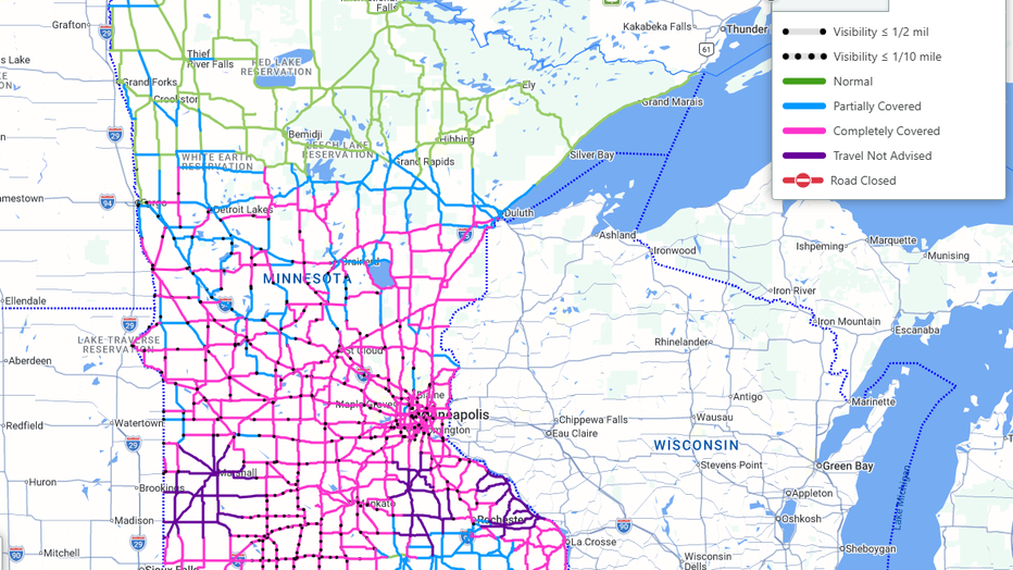
Authorities are urging no travel across roads in southwestern Minnesota, near Marshall, and southeastern Minnesota, near Owatonna, Faribault and near Rochester, Sunday morning due to white-out conditions and blowing snow.
Meanwhile, many roads in much of Minnesota are covered in snow, and there are reports of reduced visibility.
These conditions are expected to continue through much of the day Sunday.
Find live road conditions here.
1 a.m. – Snow totals so far in Minnesota
The National Weather Service shared some reported snow totals so far. Here they are:
Minneapolis-St. Paul International Airport: 5 inchesChanhassen: 5 inchesEau Claire, Wisconsin: 4 inches Winter WeatherMinnesotaTrafficTravel