
Record-shattering March heat is forecast across the Bay Area this week as temperatures are anticipated to surge into the 90s, as much as 30 degrees above normal for this time of year.
It won’t be a short-lived spike in temperatures: “It is going to be a marathon,” the National Weather Service said.
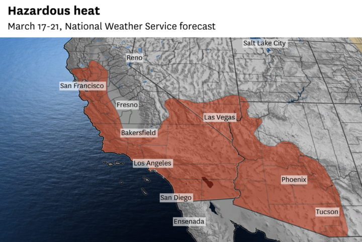
What once looked like a two- to four-day heat wave now appears will last five days or more. The high-pressure system responsible for the looming heat is predicted to linger over the Southwest in a feedback loop described as a “heat dome,” trapping the region beneath a bubble of scorching heat.
The weather service on Saturday issued a heat advisory going into effect at 10 a.m. Monday and continuing until 8 p.m. Friday for the entire Bay Area, excluding Solano County.
San Francisco’s high temperature is forecast to be 84 degrees or higher Monday through Friday, according to the weather service. It would tie the longest such stretch in any month since the city’s official weather station moved to the Mission District in 2007.
Tuesday and Friday are predicted to be the hottest days, at 88 degrees, which would shatter San Francisco’s all-time March temperature record of 87 degrees, set in 2005. Temperature records began in the city in 1875.
It’ll be even hotter elsewhere.
San Jose is expected to flirt with 95 degrees Tuesday through Friday. A 95-degree reading would break the old March record by 6 degrees, tying San Jose’s biggest margin to beat a previous monthly temperature record in more than a century.
“Near Oakland you could be cracking 90 … near 100 if you’re going to Pinnacles (National Park),” said Karleisa Rogacheski, a meteorologist at the weather service office in Monterey.
There’s a low-end chance of triple-digit heat in the Santa Cruz Mountains, interior East Bay valleys and the Oakland and Berkeley hills.
Minor fluctuations in day-to-day temperatures are expected through Friday, but they’ll hardly be noticeable as each day has the potential to shatter records.
Long March nights will limit the duration of extreme daytime heat, but limited overnight relief is expected. Most areas will remain in the 60s by Tuesday night, with hills areas above 500 feet possibly remaining in the 70s, including Twin Peaks and the Oakland and Berkeley hills. These are known as thermal belts.
A moderate risk of heat-related impacts is expected for nearly the entire Bay Area, probably affecting sensitive populations such as the elderly or people with underlying health conditions. The weather service recommends people seek adequate cooling and remain properly hydrated.
“It’s very unusual for this time of year to have these temperatures,” Rogacheski said. “It’s not going to be what our bodies are used to.”
Above-normal temperatures are forecast to continue through next weekend, but the stubborn area of high pressure may finally begin to break.
“It really doesn’t start moving until Saturday night. … We should see some relief Sunday,” Rogacheski said. “By Monday we start to see some more zonal flow. That is a good indicator across all the models that we won’t have those unusually high temperatures.”
Temperatures this high would have been nearly impossible in past decades. Anthropogenic greenhouse gas emissions are trapping heat in the atmosphere and resulting in more extreme heat records and less frequent instances of extreme cold.