

CP24’s Jessica Smith provides an update on weather conditions in Toronto and parts of the GTA.
While March Break may have seen a mild start, a “sharp arctic cold front” will cause winds bringing a “sudden return to winter,” according to Environment Canada.
At 6:10 p.m., the national weather agency issued a special weather statement for Burlington – Oakville, Caledon, the City of Hamilton, the City of Toronto, Halton Hills – Milton, Mississauga – Brampton, Newmarket – Georgina – Northern York Region, Niagara Falls – Welland – Southern Niagara Region, and Vaughan – Richmond Hill – Markham, advising of strong winds gusting 70 to 80 km/h as well as 2 to 4 cm of snow and blowing snow later Monday evening into the overnight hours.
“Strong west to northwest winds will continue in the wake of a sharp Arctic cold front. Winds will slowly begin to ease Tuesday morning,” it said.
“High winds may toss loose objects or cause tree branches to break. Local utility outages are possible.”
The agency also advised that with the arrival of snow from a disturbance tracking northward over the area in the wake of the cold front, blowing and drifting snow is expected, especially in open areas tonight.
“As a result, there will be a quick return to winter driving conditions,” Environment Canada said.
St. Catharines – Grimsby – Northern Niagara Region, meanwhile, could see strong northwest wind gusts up to 90 km/h, says Environment Canada, along with 5 cm of snow and blowing snow starting on Monday night and easing by Tuesday morning.
Up to 10 cm of snow expected in Durham
Earlier today, a special weather statement was issued for Pickering – Oshawa – Southern Durham Region and Uxbridge – Beaverton – Northern Durham Region, which it said could see 5 to 10 cm of accumulating snow that can reduce visibility when the winds kick up.
The agency said this system is expected to arrive on Monday night and continue through Tuesday morning.
“As much colder arctic air floods in tonight, snow is expected to rapidly develop with a general snowfall of 5 to 10 cm expected by Tuesday morning. A few localities may receive 10 to 15 cm of snow,” it said.
“With the arrival of snow tonight, blowing and drifting snow especially in exposed areas will cause a sudden return to winter driving conditions.”
Yellow warning for wind in Niagara, areas near Lake Erie
A yellow warning for wind is also in effect for Niagara Falls – Welland – Southern Niagara Region and areas near Lake Erie.
Residents there could see strong southwest winds gusting up to 90 km/h that “may cause damage,” Environment Canada said.
“Winds will shift to the west and ease slightly this evening. Westerly winds gusting to 70 km/h will continue into Tuesday morning,” it said.
The weather could possibly cause local power outages and damage to roofs or fences, the agency said, urging residents to secure loose objects.
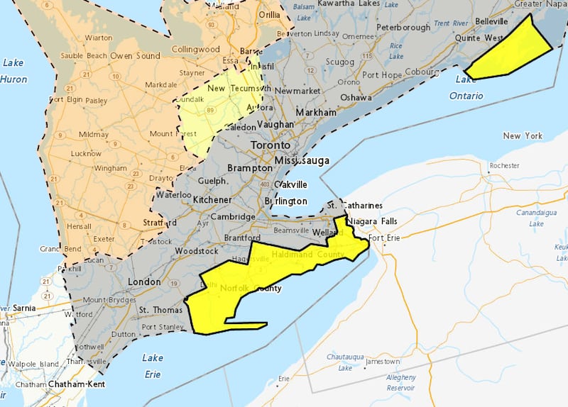 Weather statement, warning map March 16 A map showing special weather statements, warnings in effect for the Greater Toronto and Hamilton Area on March 16. (Environment Canada image) Toronto weather
A big temperature drop is expected on Tuesday in Toronto.
Environment Canada is calling for a chance of flurries and a high of -3 C on Tuesday, feeling closer to -19 in the morning.
A high of -2 C is in the forecast on Wednesday before more seasonable daytime highs of 4 C return on Thursday and Friday.