
The Regional District of Nanaimo downgraded an evacuation order for an area near the Wesley Ridge wildfire on Wednesday afternoon, though many homes still remain under an evacuation order.
At 4 p.m., the evacuation order was downgraded to an evacuation alert for several streets, including Ashling Road, Dolly Varden Way and Meadowood Way, affecting about a third of the properties that were under an evacuation order earlier in the day.
The evacuation order remains in place for surrounding areas.
A map of the evacuation orders and alerts can be found below:
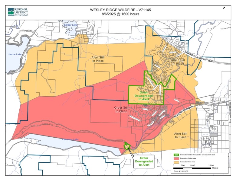 The evacuation alert map is shown as of 4 p.m. on Aug. 6, 2025. (RDN)
“All properties being downgraded to Evacuation Alert today have been assessed to ensure it is safe to return home,” said the RDN in its notice Wednesday afternoon.
“Please know our first priority is getting residents home as soon as it is safe to do so. We understand that it is disappointing that not all evacuees are able to return home at this time,” added the regional district.
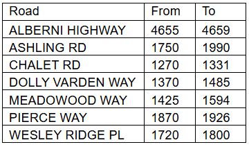
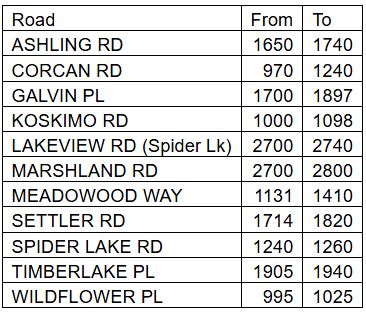
The properties under the evacuation order as of 4 p.m. on Aug. 6 include:
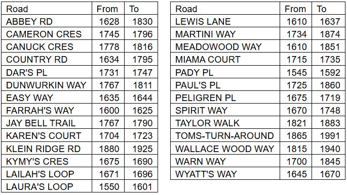
The properties under the evacuation alert as of 4 p.m. on Aug. 6 include:
 Aug. 6, 2025. (RDN)
 Aug. 6, 2025. (RDN)
People living in an evacuation order zone must leave the area immediately. Those living in an evacuation alert zone should be prepared to leave on short notice.
The latest updates on the evacuation order and alert can be found on the Regional District of Nanaimo website.
Douglas Holmes with the Regional District of Nanaimo said Wednesday afternoon that it’s the RDN’s goal to “return people to their homes as soon as it is safe to do so.”
RELATED: Air Quality advisory for parts of Vancouver Island due to wildfire smoke
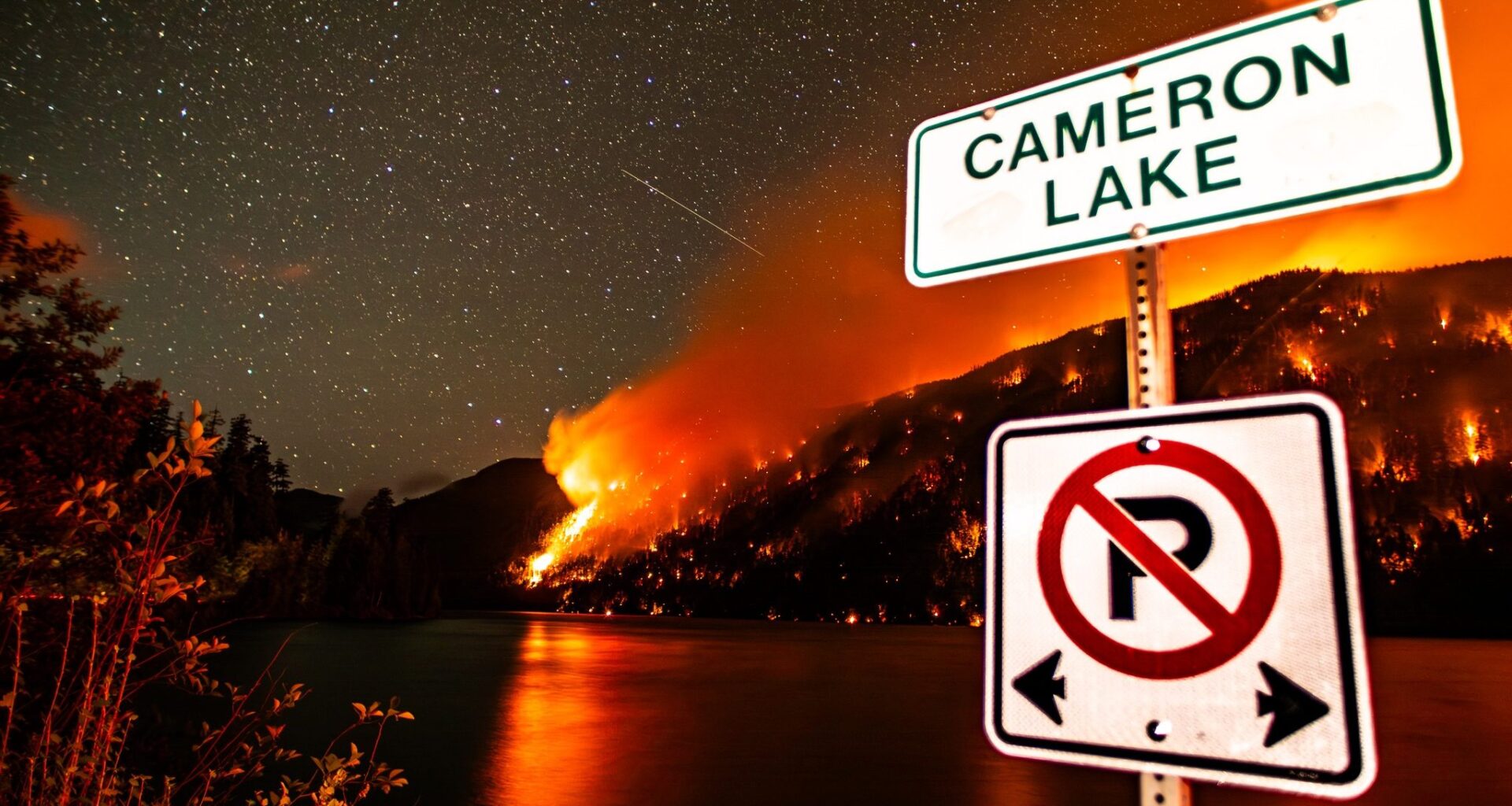
The Wesley Ridge wildfire on Vancouver Island grew by an estimated 27 hectares on Wednesday, and hundreds of nearby residents remain under evacuation orders and alerts.
As of 3 p.m. on Aug. 6, the wildfire on the north side of Cameron Lake measures approximately 538 hectares, up from 511 the day before.
A total of 185 firefighting personnel are battling the wildfire, as well as nine helicopters, 11 pieces of heavy equipment, and several local fire departments, the BCWS said in an update on Wednesday.
The wildfire service says the priority continues to be the protection of homes, properties and other critical infrastructure, like power lines and Highway 4, which is located on the opposite side of Cameron Lake as the wildfire.
“At this time no homes have been lost, and we know that it is very important for the surrounding communities as well that Highway 4, which is critical infrastructure, is functional for travel,” said Kelly Greene, B.C. minister of emergency management and climate readiness, at a news conference early Wednesday afternoon.
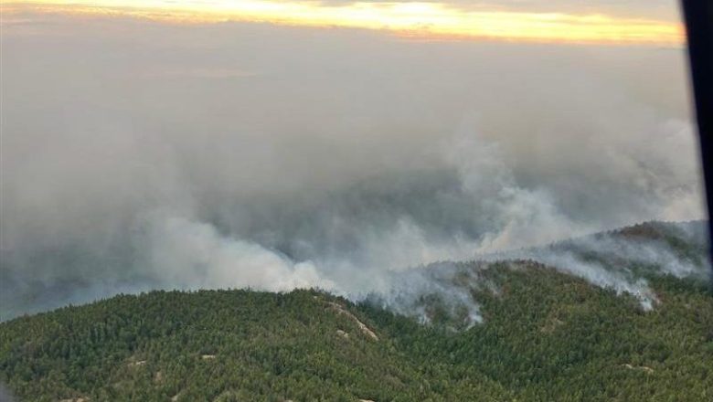 The B.C. Wildfire Service provided this photo of the Wesley Ridge wildfire, captured on the morning of Tuesday, Aug. 5, 2025. (BCWS)
The BCWS says that it has 24-hour wildfire operations running at the Wesley Ridge fire, including helicopters equipped with night vision.
Madison Dahl, fire information officer with the Coastal Fire Centre, adds that firefighters made “excellent progress” protecting residential areas and establishing a perimeter around the fire.
“There was very little fire activity overnight near residences on Wesley Ridge and west Cameron Lake area,” said the BC Wildfire Service on Wednesday. “Night vision equipped helicopters continued to monitor the fire throughout the evening as was operationally necessary.”
Wet and cooler weather
Light rain also fell over the area Tuesday, and higher humidity and cooler temperatures helped with suppression, according to the BCWS.
A total of 1.4 millimetres of rain was recorded over the wildfire between Tuesday afternoon and Wednesday morning.
The precipitation was welcome news to locals in the Whiskey Creek area who had, up to that point, seen nearly a week of unrelenting heat after the wildfire sparked on July 31.
“So happy. Come on rain. More, more, more,” said Whiskey Creek resident Alanna Tinney on Tuesday.
READ & WATCH: ‘Come on rain’: Rain brings hope to people living near Wesley Ridge wildfire
Cliff Chapman, director of provincial wildfire operations with the BC Wildfire Service, says the rainfall is helpful, but “not enough” to make a major dent in the wildfire.
“So it does rest conditions, but only on a micro scale,” he said.
The BCWS is anticipating the weather to remain cool and wet into Thursday, before becoming hotter and drier again late Thursday and into Friday.
Ravi Parmar, B.C. minister of forests and MLA for Langford-Highlands, says there are currently 120 wildfires burning across the province as of Wednesday afternoon, “including 12 that have started in the past 24 hours and 27 that were considered put out over the same period.”
As of Wednesday afternoon, the Wesley Ridge wildfire remains the only “wildfire of note” across British Columbia.
A wildfire of note means the fire is “creating an increased level of interest” and is “especially visible or poses a threat to public safety,” according to the BCWS.
So far, there have been just over 850 wildfires recorded in B.C. this year, down from roughly 1,000 seen during the same time period last year.
While the number of wildfires is down, Parmar is reminding the public to be cautious and to respect fire bans.
He pointed to the B.C. Conservation Officer Service handing out more nearly $30,000 in fines for illegal campfires over the B.C. Day Long weekend, including two tickets that were issued on Vancouver Island.
The BCWS says there have been no reports of major injuries among firefighters battling the blaze.
Chapman says some minor injuries are typical when dealing with fires of the size, particularly since the Wesley Ridge fire is located in a steep and difficult terrain.
He adds that one of the province’s five incident management teams used for wildfire response has been dispatched to the Cameron Lake area, and that one of its priorities is safety among firefighters and community members.
The latest information on the wildfire can be found on the BCWS website, while the latest updates on evacuation orders and alerts can be found on the RDN website.
With files from CHEK’s Skye Ryan and Ethan Morneau
RELATED: