
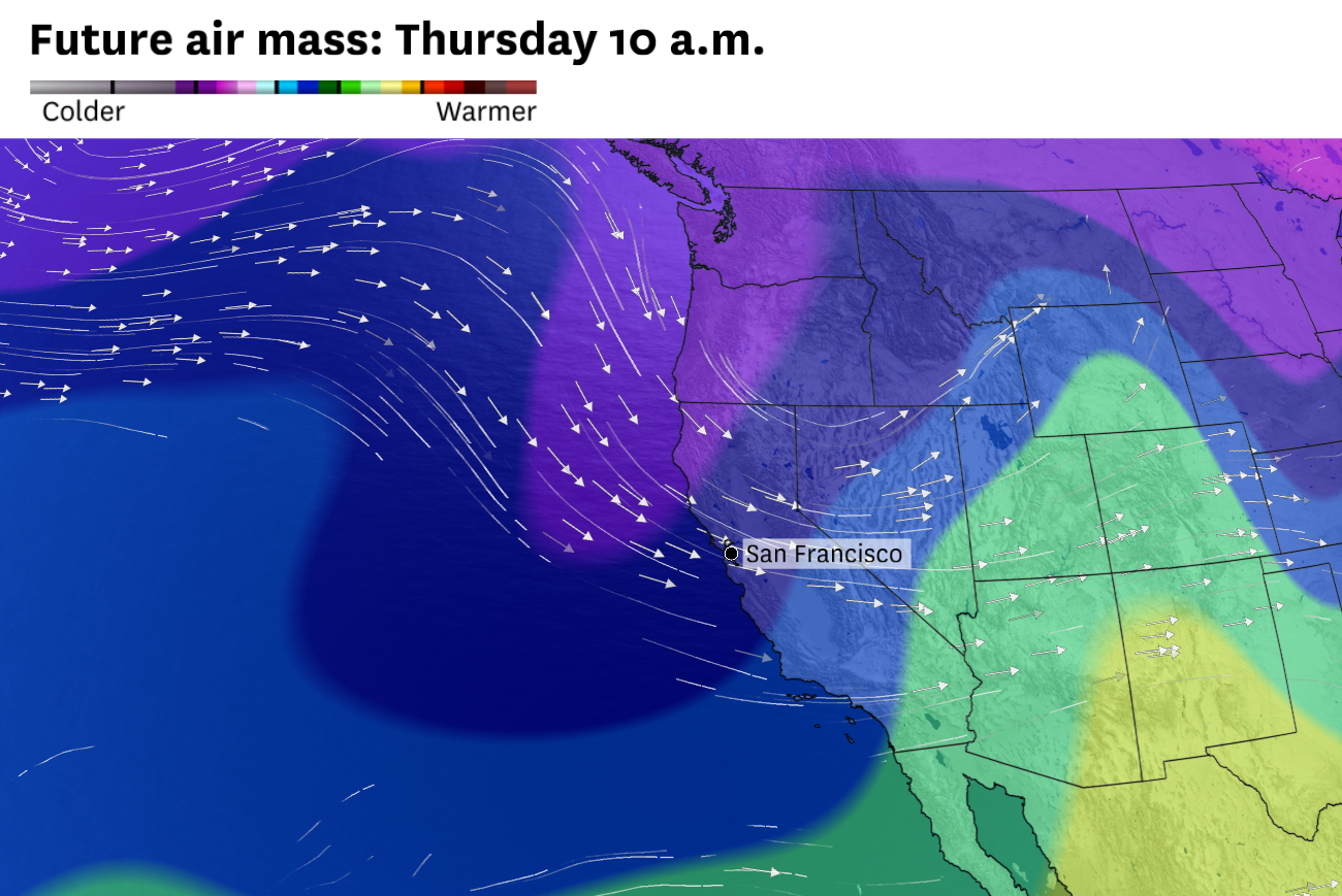
A cooler-than-normal air mass will push over Northern California on Wednesday and Thursday, ending a record warm spell that lasted for weeks. The system is predicted to bring a fresh coating of snow to the Sierra Nevada.
Baron/Lynx
After weeks of record-breaking March heat, California is finally in for a reprieve.
The stubborn area of high pressure that resulted in weeks of unseasonably hot weather across the Southwest will start to break down Monday and get nudged eastward by Tuesday. Its movement will open the door for cooler, wetter Pacific air to flood California.
Article continues below this ad
Temperatures will finally return to normal across the state Tuesday and drop below seasonal norms Wednesday and Thursday in Northern California. That’ll put highs in the 60s in the Bay Area and Sacramento Valley and the 30s and 40s in the mountains. Temperatures will even drop below freezing at night in the Sierra Nevada for the first time in weeks.
Previous forecasts indicated widespread precipitation was possible from the Oregon border to the Mexico border, but weather models have since backed away from that outcome. Instead, it appears two separate systems will clip California, but neither will pack a big punch in the major metropolitan areas. San Francisco and Los Angeles may escape the week with only a few hours of drizzle.
San Francisco Chronicle Logo
Make us a Preferred Source to get more of our news when you search.
Add Preferred Source
A disorganized system between Hawaii and California is forecast to move eastward Tuesday and spread subtropical moisture over the Golden State. What the system carries in moisture it is expected to lack in organization. That makes it tricky to pin down where rain showers may develop.
Clouds were spinning counterclockwise around a broad area of low pressure over the northeastern Pacific Ocean on Sunday afternoon.
NOAA/GOES-18
A disorganized storm system over the eastern Pacific Ocean was pushing clouds over California on Sunday. The system was predicted to generate light rain and high-elevation snow Tuesday.
Article continues below this ad
The Central Coast from Monterey to Santa Barbara is most likely to pick up at least a tenth of an inch of rain Tuesday, though drizzle is possible in San Francisco and Los Angeles. The best chance of rain in the Central Valley will probably be from an afternoon or evening thunderstorm, including in Redding, Sacramento and Fresno.
Light rain showers are predicted across California on Tuesday. Weather models simulate the most widespread showers somewhere between San Francisco and Los Angeles, though totals are forecast to remain below a tenth of an inch in most places.
Baron/Lynx
The National Weather Service said up to a quarter-inch of rain is possible in the Bay Area, though zero accumulation is just as likely.
“No matter how you slice it, it’s not a lot of accumulation,” said Nicole Sarment, a weather service meteorologist.
If San Francisco stays dry Tuesday, it’ll wrap up the city’s driest March in more than a century.
Article continues below this ad
Light to moderate snow is possible in the Sierra on Tuesday, mainly above 7,500 feet. Showers below that elevation, including in Tahoe, will probably fall as rain or a mix of rain and snow.
While Tuesday’s potential for significant precipitation fizzled down the home stretch, a more impactful system is possible Wednesday. An organized low-pressure system is predicted to move into the Pacific Northwest and share leftovers with Northern California.
A cold front was forecast to bring light to moderate coastal and valley rain and mountain snow to Northern California on Wednesday evening.
Baron/Lynx
A cold front associated with the area of low pressure will bring a chance of rain from roughly San Jose northward Wednesday evening through Thursday morning. It probably won’t be a washout in the Bay Area, but if the front remains organized long enough it could bring a few hours of moderate rain to San Francisco.
While it’s still uncertain how much rain the Bay Area will get from the second system, there’s higher confidence that it’ll bring the northern Sierra its most snow in six weeks. It could drop a half-foot of snow in Tahoe, just enough to freshen up the slopes before the final weekend of the season at many resorts.
Article continues below this ad
Dry, warm weather will return Friday. Widespread 80-degree temperatures are predicted for the first weekend of April.
Monday breakdown
San Francisco: More clouds and enhanced onshore winds will cap high temperatures in the mid- to upper 60s west of Twin Peaks and in the Presidio and the Marina and in the low 70s in the Mission District, Noe Valley, Potrero Hill, Portola and downtown. There’s a slight chance of a light rain shower overnight. Lows will be in the mid-50s.
North Bay: Partly to mostly cloudy skies will cause temperatures to drop by a few degrees from Sunday’s highs. Vallejo, Fairfield, Vacaville and Santa Rosa should still reach the low 80s, while Petaluma, Napa, San Rafael and Sonoma top out in the mid- to upper 70s. Southwest winds will pick up in the evening and remain breezy overnight, particularly in Napa Valley and Solano County close to San Pablo Bay, with gusts up to 25 mph. Lows will be in the low to mid-50s with a slight chance of a light rain shower.
East Bay: The Caldecott Tunnel will probably mark the dividing line between 70- and 80-degree temperatures as a weak bay breeze keeps Bekeley, Oakland, Hayward and Fremont in the low to mid-70s while Interstate 680 corridor heats up to the low 80s. Clouds will increase throughout the day and give way to a slight chance of light rain overnight.
Article continues below this ad
Pacific Coast and Peninsula: Increasing clouds and a slight wind shift will knock temperatures down across the Peninsula. Highs will be in the low to mid-60s at the beaches, close to normal for this time of year. Warmer-than-normal weather will continue elsewhere, with highs ranging from around 70 degrees in South San Francisco to the upper 70s in Redwood City, with San Mateo somewhere in between. Overnight lows will be in the mid-50s with a slight chance of a rain shower.
South Bay and Santa Cruz: Overcast skies are expected to cap a few degrees lower than Sunday’s highs. San Jose, Cupertino, Morgan Hill, Gilroy, Scotts Valley and Boulder Creek could still hit 80 degrees, with mid- to upper 70s in Sunnyvale, Mountain View, Santa Clara and Milpitas. A more pronounced marine layer should cap Santa Cruz in the upper 60s to low 70s. Overnight lows will be in the mid- to upper 50s with a slight chance of light rain.