
Friday is a First Alert Weather Alert Day for the risk of strong, severe thunderstorms across the area.A Tornado Watch has been issued for the majority of the Kansas City viewing area until 9 p.m.Click here to track radar | Click here to see active alerts | Click here to track school closings | Click here to download the KMBC 9 News app | Here’s how to sign up for custom weather alerts Live storm updates:6:21 p.m. – A TORNADO WARNING has been issued for Bates County, Missouri, until 6:45 p.m.6:16 p.m. – From CPKC:Weather conditions at CPKC Stadium have improved. Tonight’s World Rugby Pacific Four Series at CPKC Stadium will kick off at 7:30 p.m. CT, weather permitting.Gates and parking lots will open at 6:45 p.m. CT, and shuttle operations will resume at 6:45 p.m. CT, weather permitting.Weather permitting, we anticipate playing both games of tonight’s doubleheader with the USA/Australia match to begin at approximately 10:15 p.m. CT.6:02 p.m. – A severe thunderstorm warning has been issued for Johnson, Lafayette, Pettis and Saline Counties in Missouri until 6:45 p.m. 5:55 p.m. – The following counties were removed from the tornado watch:Kansas: Atchison County, Doniphan County, Johnson County, Leavenworth County, Wyandotte County.Missouri: Andrew County, Buchanan County, Caldwell County, Clay County, Clinton County, Daviess County, DeKalb County, Gentry County, Grundy County, Harrison County, Holt County, Mercer County, Nodaway County, Platte County, Worth County.5:45 p.m. – The tornado warning has been allowed to expire. 5:43 p.m. – A severe thunderstorm warning has been issued for Adair, Macon and Schuyler Counties in Missouri until 6:30 p.m. 5:39 p.m. – A severe thunderstorm warning has been issued for Bates and Henry Counties in Missouri until 6:45 p.m. 5:24 p.m. – TDS reported near Belton, Missouri. Possible tornado on the ground. 5:18 p.m. – Johnson and Miami Counties have been REMOVED from the tornado warning. The warning continues for Cass and Jackson Counties. 5:17 p.m. – A severe thunderstorm warning has been issued for Johnson, Miami and Wyandotte Counties in Kansas until 5:45 p.m. Wind gusts up to 70 miles per hour possible. 5:13 p.m. – A TORNADO WARNING has been issued for Johnson and Miami Counties in Kansas and Cass and Jackson Counties in Missouri until 5:45 p.m. 5:11 p.m. – A severe thunderstorm warning has been issued for Bates MO, Caldwell MO, Carroll MO, Cass MO, Clay MO, Henry MO, Jackson MO, Johnson MO, Lafayette MO, Ray MO until 6:30 p.m. 5:03 p.m. – A severe thunderstorm warning has been issued for Bates, Cass and Jackson Counties in Missouri until 6 p.m. NWS said this portion of the storm could see up to 80 mph wind gusts, this prompts an EAS warnings to area phones and will trigger some outdoor warning sirens. 5:02 p.m. – A flash flood warning has been issued for Johnson and Wyandotte Counties in Kansas, and Clay, Jackson and Johnson Counties in Missouri until 9 p.m. 4:59 p.m. – A severe thunderstorm warning has been issued for Adair, Macon, Putnam and Schuyler Counties in Missouri until 5:45 p.m. 4:53 p.m. – A severe thunderstorm warning has been issued for Adair, Caldwell, Daviess, Grundy, Linn, Livingston, Macon and Sullivan Counties in Missouri until 5:45 p.m. 4:45 p.m. – A severe thunderstorm warning has been issued for Johnson, Leavenworth and Wyandotte Counties in Kansas and Clay, Jackson, Platte and Ray Counties in Missouri until 5:30 p.m.4:35 p.m. – A severe thunderstorm warning has been issued for Cass County, Missouri, and Johnson, Linn and Miami Counties in Kansas until 5:15 p.m. Wind gusts for this portion of the storm could approach 80 mph. 4:27 p.m. – A severe thunderstorm warning has been issued for Johnson County, Kansas, until 5: 15 p.m. 4:24 p.m. – A TORNADO WARNING has been issued for Adair, Linn, Macon and Sullivan Counties in Missouri until 5:15 p.m. 4:20 p.m. – A severe thunderstorm warning has been issued for Caldwell, Clinton, Daviess, DeKalb, Grundy and Livingston Counties in Missouri until 5 p.m. 4:11 p.m. – The tornado warning for Grundy and Livingston Counties has been canceled. The warning remains in place for Linn and Sullivan Counties. 4:09 p.m. – A severe thunderstorm warning has been issued for Adair, Mercer, Putnam, Schuyler and Sullivan Counties in Missouri until 5 p.m. 3:56 p.m. – A severe thunderstorm warning has been issued for Grundy, Linn, Livingston, Mercer, and Sullivan Counties in Missouri until 5 p.m.3:46 p.m. – A TORNADO WARNING has been issued for Grundy, Linn, Livingston and Sullivan Counties in Missouri until 4:30 p.m. 3:45 p.m. – The tornado warning for Buchanan, Clinton, and Platte Counties in Missouri has been CANCELED.3:39 p.m. – A severe thunderstorm warning has been issued for Grundy, Linn, Livingston, Mercer and Sullivan Counties in Missouri until 4:15 p.m. 3:33 p.m. – A severe thunderstorm warning has been issued for Grundy, Harrison, Mercer, Putnam, and Sullivan Counties in Missouri until 4 p.m. 3:36 p.m. – A severe thunderstorm warning has been issued for Mercer, Putnam and Sullivan Counties in Missouri until 4:15 p.m. 3:25 p.m. – A TORNADO WARNING has been issued for Buchanan, Clinton and Platte Counties in Missouri until 4 p.m. 3:22 p.m. – Nick Bender spots a rotating wall cloud.3:17 p.m. – You never know when Storm Tracker 9 might pull into your driveway. Nick Bender spotted a wall cloud in an area of concern. Here’s what happened:3:14 p.m. – A severe thunderstorm warning has been issued for Mercer and Putnam Counties in Missouri until 3:45 p.m. 3:11 p.m. – A severe thunderstorm warning has been issued for the following counties in Missouri until 4:15 p.m.: Andrew County, Buchanan County, Clinton County, Daviess County, DeKalb County, Gentry County, Harrison County.3:09 p.m. – A severe thunderstorm warning has been issued for Caldwell, Carroll, Daviess and Livingston Counties in Missouri until 4 p.m. 3:08 p.m. – A severe thunderstorm warning has been issued for Atchison and Doniphan Counties in Kansas and Andrew, Buchanan, Holt and Platte Counties in Missouri until 3:45 p.m. 2:57 p.m. – A TORNADO WARNING has been issued for Atchison County, Kansas, and Basehor and Platte Counties in Missouri until 3:30 p.m. 2:52 p.m. – Officials with CPKC Stadium say due to forecasted inclement weather, the start of tonight’s World Rugby Pacific Four Series has been delayed until further notice. They anticipate play starting at 7 p.m., weather-permitting. 2:51 p.m. – A severe thunderstorm warning has been issued for Daviess, Grundy, Linn, Livingston, Mercer, Putnam and Sullivan Counties in Missouri until 3:30 p.m. 2:47 p.m. – The NWS has issued a severe thunderstorm warning for Doniphan County, Kansas, and Andrew, DeKalb and Gentry Counties in Missouri until 3:15 p.m.2:41 p.m. – A severe thunderstorm warning has been issued for Caldwell and Ray Counties in Missouri until 3:15 p.m.2:39 p.m. – Ray County has been removed from the severe thunderstorm warning. 2:35 p.m. – The NWS has issued a severe thunderstorm warning for Gentry, Harrison and Worth Counties in Missouri until 3:15 p.m.2:27 p.m. – The NWS has issued a severe thunderstorm warning for the following counties until 3:15 p.m.Kansas: Atchison County, Doniphan County.Missouri: Buchanan County, Caldwell County, Carroll County, Daviess County, Grundy County, Livingston County, Platte County, Ray County.1:42 p.m. – The National Weather Service has issued a TORNADO WATCH for the following counties through 9 p.m.:Kansas (7 counties): Atchison County, Doniphan County, Johnson County, Leavenworth County, Linn County, Miami County, Wyandotte County.Missouri (36 counties): Adair County, Andrew County, Bates County, Buchanan County, Caldwell County, Carroll County, Cass County, Chariton County, Clay County, Clinton County, Cooper County, Daviess County, DeKalb County, Gentry County, Grundy County, Harrison County, Henry County, Holt County, Howard County, Jackson County, Johnson County, Lafayette County, Linn County, Livingston County, Macon County, Mercer County, Nodaway County, Pettis County, Platte County, Putnam County, Randolph County, Ray County, Saline County, Schuyler County, Sullivan County, Worth County.Friday storm timeline:Data shows storms firing up ahead of a cold front, as early as 1 p.m. in the Kansas City metro area. Then, when that front passes through between 3 p.m. and 5 p.m., we’ll see a second round of thunderstorms.Those storms should move out of the metro area as early as 7 p.m., with the entire system moving east of our coverage area between 9 and 10 p.m.Friday’s storm risks:The biggest risk during this time remains strong straight-line winds, with models showing some over 70 miles per hour. Data released just before noon Friday shows the Kansas City area has been moved up to a larger risk level for strong winds. Specifically, we’ve moved from an “enhanced” risk to a “moderate” risk, or a 4 out of 5 on the risk scale. The storms also show the potential for strong hail cores, producing baseball-sized hail on the ground, and could support a tornado or two.KMBC 9’s Futurescan also shows the storms starting to bow as they pass over Kansas City. A bow echo is where we see outflow winds coming from the thunderstorms. Those will accelerate at that speed of over 70 miles per hour as the storms push through Henry and Johnson Counties in Missouri. Be prepared:The Storm Prediction Center has given the area a broad brush for severe risks tonight, and Kansas City is now included in the risk for the strongest winds. Make sure you’ve got any loose items outside tied down. This system could be over our area during the peak evening commute. Use caution if you must head out on the roads. Make sure you have multiple ways to receive severe weather alerts like the KMBC 9 News app, EAS alerts on your phone, or a NOAA Weather Radio. We could still see a few light showers into the overnight hours, but nothing severe.The best news is that we have a beautiful, calm weekend ahead. It will be a little colder on Saturday with a breezy high of 58 degrees. We’ll drop down to 38 degrees Sunday morning, and back up to 69 degrees Sunday afternoon. Our next chance for showers and storms won’t be until next Thursday and Friday.
KANSAS CITY, Mo. —
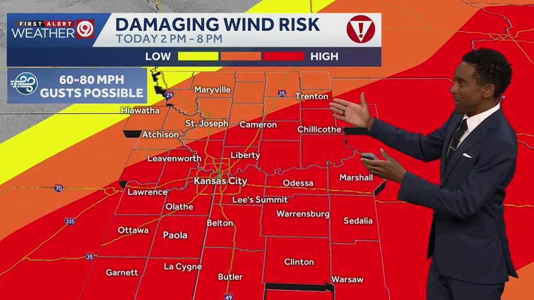
Friday is a First Alert Weather Alert Day for the risk of strong, severe thunderstorms across the area.
A Tornado Watch has been issued for the majority of the Kansas City viewing area until 9 p.m.
Click here to track radar | Click here to see active alerts | Click here to track school closings | Click here to download the KMBC 9 News app | Here’s how to sign up for custom weather alerts
Live storm updates:
6:02 p.m. – A severe thunderstorm warning has been issued for Johnson, Lafayette, Pettis and Saline Counties in Missouri until 6:45 p.m.
5:55 p.m. – The following counties were removed from the tornado watch:
Kansas: Atchison County, Doniphan County, Johnson County, Leavenworth County, Wyandotte County.
Missouri: Andrew County, Buchanan County, Caldwell County, Clay County, Clinton County, Daviess County, DeKalb County, Gentry County, Grundy County, Harrison County, Holt County, Mercer County, Nodaway County, Platte County, Worth County.
5:45 p.m. – The tornado warning has been allowed to expire.
5:43 p.m. – A severe thunderstorm warning has been issued for Adair, Macon and Schuyler Counties in Missouri until 6:30 p.m.
5:39 p.m. – A severe thunderstorm warning has been issued for Bates and Henry Counties in Missouri until 6:45 p.m.
5:24 p.m. – TDS reported near Belton, Missouri. Possible tornado on the ground.
5:18 p.m. – Johnson and Miami Counties have been REMOVED from the tornado warning. The warning continues for Cass and Jackson Counties.
5:17 p.m. – A severe thunderstorm warning has been issued for Johnson, Miami and Wyandotte Counties in Kansas until 5:45 p.m. Wind gusts up to 70 miles per hour possible.
5:13 p.m. – A TORNADO WARNING has been issued for Johnson and Miami Counties in Kansas and Cass and Jackson Counties in Missouri until 5:45 p.m.
5:11 p.m. – A severe thunderstorm warning has been issued for Bates MO, Caldwell MO, Carroll MO, Cass MO, Clay MO, Henry MO, Jackson MO, Johnson MO, Lafayette MO, Ray MO until 6:30 p.m.
5:03 p.m. – A severe thunderstorm warning has been issued for Bates, Cass and Jackson Counties in Missouri until 6 p.m. NWS said this portion of the storm could see up to 80 mph wind gusts, this prompts an EAS warnings to area phones and will trigger some outdoor warning sirens.
5:02 p.m. – A flash flood warning has been issued for Johnson and Wyandotte Counties in Kansas, and Clay, Jackson and Johnson Counties in Missouri until 9 p.m.
4:59 p.m. – A severe thunderstorm warning has been issued for Adair, Macon, Putnam and Schuyler Counties in Missouri until 5:45 p.m.
4:53 p.m. – A severe thunderstorm warning has been issued for Adair, Caldwell, Daviess, Grundy, Linn, Livingston, Macon and Sullivan Counties in Missouri until 5:45 p.m.
4:45 p.m. – A severe thunderstorm warning has been issued for Johnson, Leavenworth and Wyandotte Counties in Kansas and Clay, Jackson, Platte and Ray Counties in Missouri until 5:30 p.m.
4:35 p.m. – A severe thunderstorm warning has been issued for Cass County, Missouri, and Johnson, Linn and Miami Counties in Kansas until 5:15 p.m. Wind gusts for this portion of the storm could approach 80 mph.
4:27 p.m. – A severe thunderstorm warning has been issued for Johnson County, Kansas, until 5: 15 p.m.
4:24 p.m. – A TORNADO WARNING has been issued for Adair, Linn, Macon and Sullivan Counties in Missouri until 5:15 p.m.
4:20 p.m. – A severe thunderstorm warning has been issued for Caldwell, Clinton, Daviess, DeKalb, Grundy and Livingston Counties in Missouri until 5 p.m.
4:11 p.m. – The tornado warning for Grundy and Livingston Counties has been canceled. The warning remains in place for Linn and Sullivan Counties.
4:09 p.m. – A severe thunderstorm warning has been issued for Adair, Mercer, Putnam, Schuyler and Sullivan Counties in Missouri until 5 p.m.
3:56 p.m. – A severe thunderstorm warning has been issued for Grundy, Linn, Livingston, Mercer, and Sullivan Counties in Missouri until 5 p.m.
3:46 p.m. – A TORNADO WARNING has been issued for Grundy, Linn, Livingston and Sullivan Counties in Missouri until 4:30 p.m.
3:45 p.m. – The tornado warning for Buchanan, Clinton, and Platte Counties in Missouri has been CANCELED.
3:39 p.m. – A severe thunderstorm warning has been issued for Grundy, Linn, Livingston, Mercer and Sullivan Counties in Missouri until 4:15 p.m.
3:33 p.m. – A severe thunderstorm warning has been issued for Grundy, Harrison, Mercer, Putnam, and Sullivan Counties in Missouri until 4 p.m.
3:36 p.m. – A severe thunderstorm warning has been issued for Mercer, Putnam and Sullivan Counties in Missouri until 4:15 p.m.
3:25 p.m. – A TORNADO WARNING has been issued for Buchanan, Clinton and Platte Counties in Missouri until 4 p.m.
3:22 p.m. – Nick Bender spots a rotating wall cloud.
3:17 p.m. – You never know when Storm Tracker 9 might pull into your driveway. Nick Bender spotted a wall cloud in an area of concern. Here’s what happened:
3:14 p.m. – A severe thunderstorm warning has been issued for Mercer and Putnam Counties in Missouri until 3:45 p.m.
3:11 p.m. – A severe thunderstorm warning has been issued for the following counties in Missouri until 4:15 p.m.: Andrew County, Buchanan County, Clinton County, Daviess County, DeKalb County, Gentry County, Harrison County.
3:09 p.m. – A severe thunderstorm warning has been issued for Caldwell, Carroll, Daviess and Livingston Counties in Missouri until 4 p.m.
3:08 p.m. – A severe thunderstorm warning has been issued for Atchison and Doniphan Counties in Kansas and Andrew, Buchanan, Holt and Platte Counties in Missouri until 3:45 p.m.
2:57 p.m. – A TORNADO WARNING has been issued for Atchison County, Kansas, and Basehor and Platte Counties in Missouri until 3:30 p.m.
2:52 p.m. – Officials with CPKC Stadium say due to forecasted inclement weather, the start of tonight’s World Rugby Pacific Four Series has been delayed until further notice. They anticipate play starting at 7 p.m., weather-permitting.
2:51 p.m. – A severe thunderstorm warning has been issued for Daviess, Grundy, Linn, Livingston, Mercer, Putnam and Sullivan Counties in Missouri until 3:30 p.m.
2:47 p.m. – The NWS has issued a severe thunderstorm warning for Doniphan County, Kansas, and Andrew, DeKalb and Gentry Counties in Missouri until 3:15 p.m.
2:41 p.m. – A severe thunderstorm warning has been issued for Caldwell and Ray Counties in Missouri until 3:15 p.m.
2:39 p.m. – Ray County has been removed from the severe thunderstorm warning.
2:35 p.m. – The NWS has issued a severe thunderstorm warning for Gentry, Harrison and Worth Counties in Missouri until 3:15 p.m.
2:27 p.m. – The NWS has issued a severe thunderstorm warning for the following counties until 3:15 p.m.
Kansas: Atchison County, Doniphan County.
Missouri: Buchanan County, Caldwell County, Carroll County, Daviess County, Grundy County, Livingston County, Platte County, Ray County.
1:42 p.m. – The National Weather Service has issued a TORNADO WATCH for the following counties through 9 p.m.:
Kansas (7 counties): Atchison County, Doniphan County, Johnson County, Leavenworth County, Linn County, Miami County, Wyandotte County.
Missouri (36 counties): Adair County, Andrew County, Bates County, Buchanan County, Caldwell County, Carroll County, Cass County, Chariton County, Clay County, Clinton County, Cooper County, Daviess County, DeKalb County, Gentry County, Grundy County, Harrison County, Henry County, Holt County, Howard County, Jackson County, Johnson County, Lafayette County, Linn County, Livingston County, Macon County, Mercer County, Nodaway County, Pettis County, Platte County, Putnam County, Randolph County, Ray County, Saline County, Schuyler County, Sullivan County, Worth County.
Friday storm timeline:
Data shows storms firing up ahead of a cold front, as early as 1 p.m. in the Kansas City metro area.
Then, when that front passes through between 3 p.m. and 5 p.m., we’ll see a second round of thunderstorms.
Those storms should move out of the metro area as early as 7 p.m., with the entire system moving east of our coverage area between 9 and 10 p.m.
Friday’s storm risks:
The biggest risk during this time remains strong straight-line winds, with models showing some over 70 miles per hour.
Data released just before noon Friday shows the Kansas City area has been moved up to a larger risk level for strong winds. Specifically, we’ve moved from an “enhanced” risk to a “moderate” risk, or a 4 out of 5 on the risk scale.

Hearst OwnedNational Weather Service
The storms also show the potential for strong hail cores, producing baseball-sized hail on the ground, and could support a tornado or two.
KMBC 9’s Futurescan also shows the storms starting to bow as they pass over Kansas City. A bow echo is where we see outflow winds coming from the thunderstorms. Those will accelerate at that speed of over 70 miles per hour as the storms push through Henry and Johnson Counties in Missouri.
Be prepared:
The Storm Prediction Center has given the area a broad brush for severe risks tonight, and Kansas City is now included in the risk for the strongest winds. Make sure you’ve got any loose items outside tied down.
This system could be over our area during the peak evening commute. Use caution if you must head out on the roads.
Make sure you have multiple ways to receive severe weather alerts like the KMBC 9 News app, EAS alerts on your phone, or a NOAA Weather Radio.
We could still see a few light showers into the overnight hours, but nothing severe.
The best news is that we have a beautiful, calm weekend ahead. It will be a little colder on Saturday with a breezy high of 58 degrees. We’ll drop down to 38 degrees Sunday morning, and back up to 69 degrees Sunday afternoon.
Our next chance for showers and storms won’t be until next Thursday and Friday.