
A looming storm is forecast to drop more than 2 feet of snow in parts of the Sierra Nevada, prompting the National Weather Service to issue winter storm warnings. It’s the second round of winter storm warnings this month in the Sierra, a rarity for April.
Warnings extend from Lassen National Park to Yosemite, Sequoia and Kings Canyon national parks from 2 a.m. Tuesday to 5 p.m. Wednesday. The heaviest snow is expected Tuesday afternoon and evening above 5,000 feet in the northern Sierra and above 7,000 feet in the southern Sierra. Additional showers Wednesday could be occasionally heavy.
The weather service warns of “significant reductions in visibility at times” and “major travel delays” from snowfall rates of 1 to 2 inches per hour. Southwest winds may gust up to 50 mph at the passes and up to 90 mph atop ridges. There is also a chance of lightning Tuesday, most likely in the Sierra foothills.
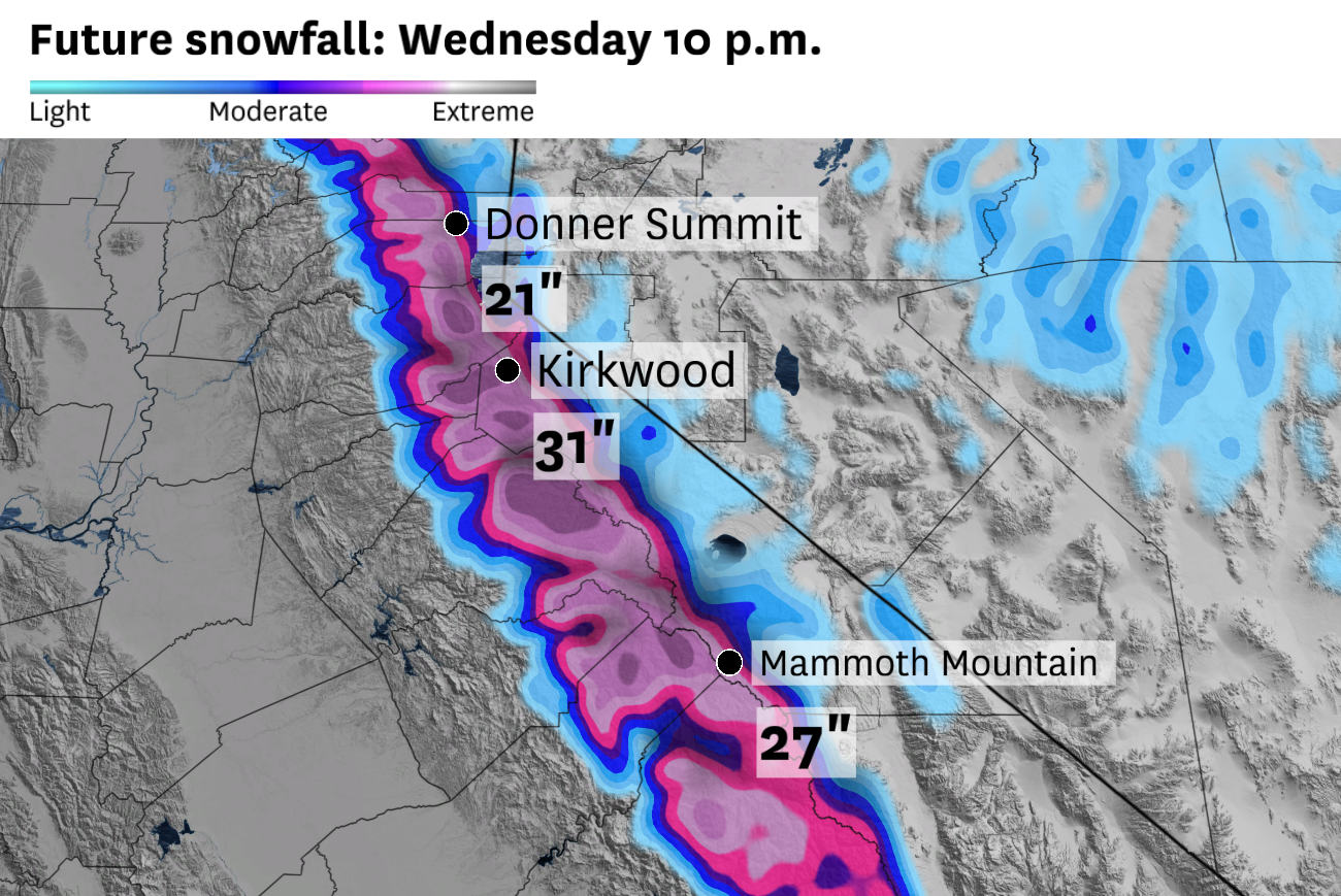
Interstate 80 over Donner Summit and Highway 50 over Echo Summit are anticipated to pick up more than a foot of snow, with the potential for up to 2 feet under the heaviest swaths of precipitation. High-elevation ski resorts like Kirkwood could pick up 2 to 3 feet of snow.
Forecast snowfall totals are more uncertain around Lake Tahoe due to the sporadic nature of showers, and the anticipated mix of rain and snow early in the storm. A winter weather advisory is in effect for the lake area.
Precipitation may start as rain in much of the Sierra on Monday, but a cold pocket of air is expected to drift over Northern California on Tuesday, raising the potential for thunderstorms. These storms often build over the Central Valley, move up the west slope of the Sierra and deposit “spillover” showers along the Tahoe shoreline. In these situations, Tahoe City, Homewood, Tahoma and South Lake Tahoe can pick up a half-foot of snow while Kings Beach and Incline Village receive only an inch or two.
“The moisture trajectory is out of the south with this storm, and that is typically not good for spillover precipitation east of the Sierra crest,” said Chris Smallcomb, a meteorologist at the weather service office in Reno.
Steady snow is expected to transition to scattered showers by Tuesday night, but some weather models predict a second, colder wave of widespread moderate snowfall Wednesday morning.
Wednesday morning’s precipitation “would have much lower rain-snow line elevations to work with,” Smallcomb said. “That scenario would bring some snow into the Reno foothills.”
It’s the second winter storm warning this month for the west slope of the Sierra, the most the weather service office in Sacramento has issued in a single April since 2010. That April, 7 feet of snow accumulated at the UC Berkeley Central Sierra Snow Lab.
April storms are propping up a scarce Sierra snowpack. California’s snowpack was just 18% of normal as of Monday morning following the state’s warmest and driest March on record.