
The Latest Information as of 7:00 a.m.
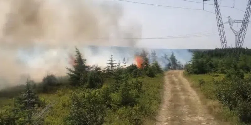
Paddy’s Pond Fire
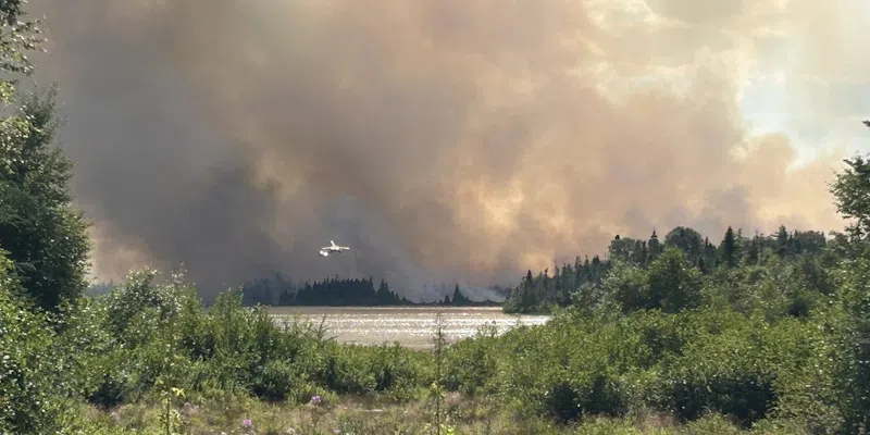
The Trans Canada Highway near Paddy’s Pond remains closed this morning as crews keep a close eye on the wildfire situation burning on the capital city’s doorstep.
The road is closed in both directions between the cloverleaf and Foxtrap Access Road.
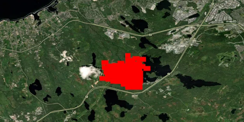
The Paddy’s Pond fire on Tuesday, August 12 via the Fire Information for Resource Management System (NASA)
The fire, which was mapped at over 200 hectares in size yesterday, is showing some growth this morning based on data provided by NASA’s Fire Information for Resource Management System.
A portion of Paradise and Conception Bay South were put on an evacuation alert last night, meaning they don’t have to leave, however they should be prepared to flee if conditions change. There are currently no advisories in place for residents of Southlands or Mount Pearl.
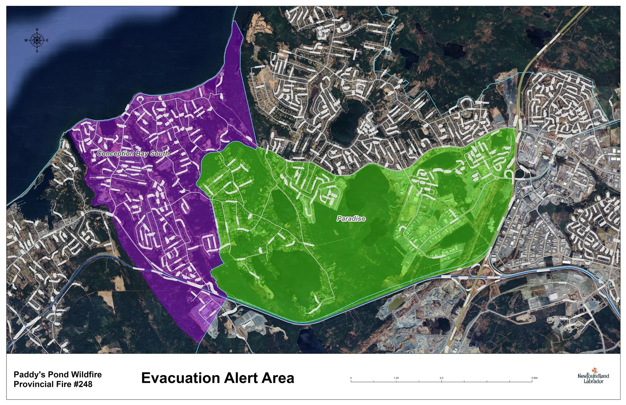
Areas of Conception Bay South and Paradise under evacuation alert (Government of Newfoundland and Labrador)
The blaze is in NL Hydro’s transmission corridor. One transmission line was impacted yesterday, however Hydro says all lines have been returned to service. The utility warns that there is still a risk of power outages if the situation worsens. Crews are monitoring equipment along with fire and smoke conditions.
Water bombers, helicopters and ground crews from this province and the mainland will be on deck today working to suppress the fire.
St. John’s mayor Danny Breen says they are keeping a close eye on the situation and the capital city is ready to step up and assist wherever needed.
Some Canada Games events have been postponed or relocated due to the fire. Information on the impact to the Games can be found here.
Conception Bay North Fire
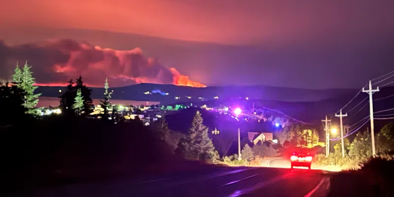
Kingston fire. (Photo courtesy Eugene Howell)
Meanwhile, the fire in Conception Bay North expanded to over 5,200 hectares in size yesterday, reaching Ochre Pit Cove.
Officials say more structures may have been impacted by the blaze.
Fire suppression efforts are continuing with the help of the Canadian Armed Forces and Coast Guard.
Martin Lake Fire
(Photo via Facebook)
The fire burning near Martin Lake in Central Newfoundland was also quite active yesterday. While the Bay d’Espoir Highway remains open at this time, government says the road may need to close at any given time should the situation intensify. Crews were working on a fire break, however equipment was removed from the site yesterday due to the increased fire activity.
Holyrood and Labrador Fires
The blaze near Holyrood is under control with crews on scene dealing with hot spots. The fire burning 20 km south of Happy Valley-Goose Bay is about half a hectare with no growth reported. Two bucketing helicopters and ground crews have been deployed in that region.
Current Evacuation ORDERS
– Town of Small Point–Adam’s Cove–Blackhead–Broad Cove
– Town of Salmon Cove
– Unincorporated area of Western Bay
– Unincorporated area of Kingston
– Unincorporated area of Perry’s Cove
– Unincorporated area of Ochre Pit Cove
– Unincorporated area of Burnt Point-Gull Island-Northern Bay
– Paddy’s Pond Industrial Area, including Akita Equipment and surrounding buildings hangers, Cochrane Pond Family Campground, Country Ribbon Chicken Farm, Sod Farm and the Forestry Depot.
Current Evacuation ALERTS
– Town of Paradise: the area on the south side of Topsail Road from the Outer Ring Road exit to CBS boundary.
– Town of Conception Bay South: starting at Paradise Outer Ring Road turn-off, on to Route 60 through to Manuels River Bridge, up Peacekeeper’s Way to the cloverleaf on the Trans-Canada Highway and back to the Paradise Trans-Canada Highway turnoff.
– Town of Victoria.
Current Evacuation ADVISORIES
– Cabin owners in the Martin Lake, Great Rattling Brook and Rushy Pond areas off Route 360 (Bay d’Espoir Highway), including all cabins from Rushy Pond to Rifle Lake (approximately 45 kilometres from the Trans-Canada Highway).