
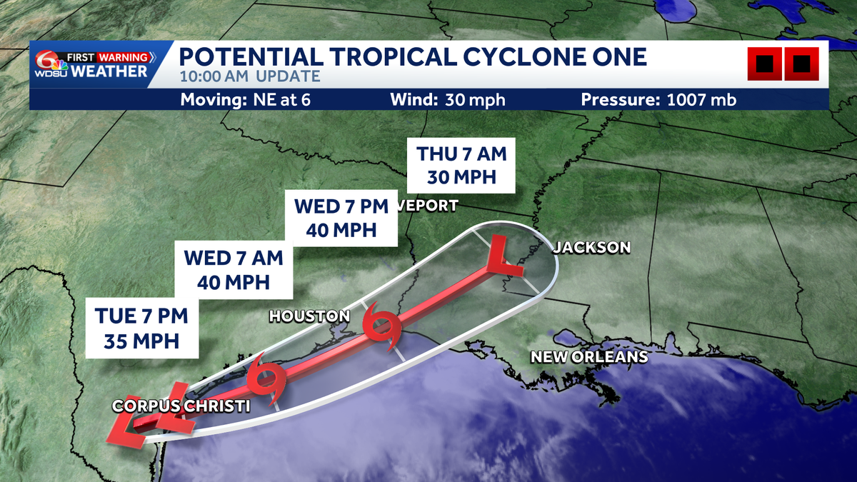
We continue to monitor Invest 90-L located over southern Texas. Refresher: an invest is an area of disturbed weather the National Hurricane Center is monitoring for possible development. Medium, 60% chance of becoming a Depression or Tropical Storm Arthur. Named storm or not, this tropical disturbance and a slow-moving June front spell big flash flood concerns this week. Most locations will see 3-6” over the next 5 days, which is manageable if it comes in waves. But, hot spots of over a foot of rain possible if the system gets closer to us by Wednesday/Thursday.Louisiana impacts: A Flood Watch is in effect for all of the Northshore, River Parishes, portions of the Bayou Parishes, and the metro through 7 a.m. Friday. WHAT DOES A FLOOD WATCH MEAN?:A Flood Watch means that conditions are favorable for flooding to occur. Use the time now to prepare for flooding if you live in a flood prone area. Be prepared to take action if a flood warning is issued.WHAT IS THE TIMING OF WEATHER?: Today:Scattered downpours throughout the dayBecomes heavier on the Northshore after 3 p.m.Isolated downpours overnightWednesday:Lighter morning showersHit or miss throughout the dayBecoming heavier evening/overnight as Invest 90L nearsThursday:Heaviest rain in the morningMore heavy downpours possible throughout the afternoonWHAT ARE THE IMPACTS?: Rainfall accumulations of 5-10 in with locally higher amounts will be possible over the Northshore and south Mississippi. 3-5 in for the river parishes and metro, and 1-3 in for the bayou and coast. These numbers are subject to change, so stay with the WDSU First Warning Weather Team for the latest.
We continue to monitor Invest 90-L located over southern Texas.
Refresher: an invest is an area of disturbed weather the National Hurricane Center is monitoring for possible development.
Medium, 60% chance of becoming a Depression or Tropical Storm Arthur.
Named storm or not, this tropical disturbance and a slow-moving June front spell big flash flood concerns this week.
Most locations will see 3-6” over the next 5 days, which is manageable if it comes in waves. But, hot spots of over a foot of rain possible if the system gets closer to us by Wednesday/Thursday.
Louisiana impacts:
A Flood Watch is in effect for all of the Northshore, River Parishes, portions of the Bayou Parishes, and the metro through 7 a.m. Friday.

WHAT DOES A FLOOD WATCH MEAN?:
A Flood Watch means that conditions are favorable for flooding to occur. Use the time now to prepare for flooding if you live in a flood prone area. Be prepared to take action if a flood warning is issued.
WHAT IS THE TIMING OF WEATHER?:
Today:
Scattered downpours throughout the dayBecomes heavier on the Northshore after 3 p.m.Isolated downpours overnight
Wednesday:
Lighter morning showersHit or miss throughout the dayBecoming heavier evening/overnight as Invest 90L nears
Thursday:
Heaviest rain in the morningMore heavy downpours possible throughout the afternoon
WHAT ARE THE IMPACTS?:
Rainfall accumulations of 5-10 in with locally higher amounts will be possible over the Northshore and south Mississippi. 3-5 in for the river parishes and metro, and 1-3 in for the bayou and coast.

These numbers are subject to change, so stay with the WDSU First Warning Weather Team for the latest.