
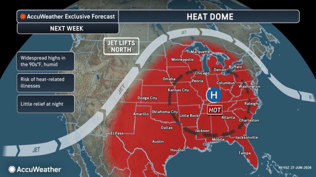
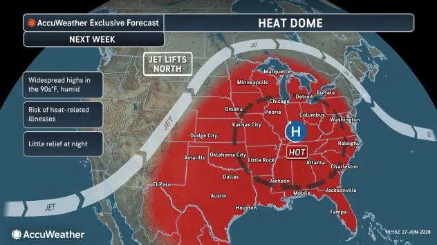
A heat dome will develop, strengthen and grow in size over much of the central United States for an extended period through the Independence Day weekend and will even expand into parts of the East for several days. At its full extent, dangerous conditions will affect more than two dozen states.
“The setup will deliver widespread highs in the 90s F with high humidity over a broad area of the Mississippi and Ohio Valleys throughout next week,” AccuWeather Meteorologist Alex Duffus said. “People who mind the heat will be very uncomfortable if they don’t have air conditioning.”
AccuWeather.com
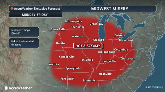
Chicago is forecast to reach 90 degrees Fahrenheit or higher for four to five consecutive days while St. Louis could endure at least eight straight days in the 90s with highs approaching 100. Typical highs this time of year are in the mid-80s in Chicago and the upper 80s in St. Louis.
“Dew point temperatures with this summer swelter will be well into the 70s in many areas,” Duffus said.
The dew point represents the saturation temperature of the air. The 70-degree mark denotes a humid day in the summertime and while common in the Southern states most of the summer, probably less than one-third of the days in the summer in the Midwest and Northeast bring dew point temperatures at or above 70.
Everyone tolerates heat differently, but as dew points climb, perspiration evaporates more slowly, making it harder for the body to cool itself. Prolonged periods of heat and humidity increase the risk of heat exhaustion and heat stroke.
AccuWeather.com
“While there will be a handful of locations that set record highs on a daily basis, there may be many more where record warmth occurs at night,” AccuWeather Meteorologist Brandon Buckingham said.
Some of the larger cities may not drop below 80 at night at the height of the heat wave.
Urban areas retain heat because pavement, concrete and brick absorb solar energy during the day and release it slowly overnight. The long daylight hours of late June and July amplify this urban heat island effect.
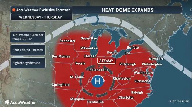
The bulk of the heat and high humidity will reach the Eastern states midweek and may linger into the Fourth of July in some areas.
Some locations may reach 100 degrees. Philadelphia, for example, is forecast to hit the century mark on two or three days despite average highs in the upper 80s. Washington, D.C., may have highs at or above 100 for as many as four days in the week ahead.
New York City could approach 100 degrees for a couple of days during the middle to latter part of the week. Across the Hudson River, Newark, New Jersey, is more likely to reach or exceed 100 on at least two days.
AccuWeather.com
Even where actual temperatures remain in the lower 90s, AccuWeather RealFeel® Temperatures are forecast to exceed 100 degrees and could top 110 during the hottest part of the day. RealFeel Temperature accounts for humidity, sunshine, wind, cloud cover and other factors that influence how hot it feels.
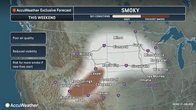
Excessive humidity won’t be the only factor limiting actual high temperatures. Smoke from wildfires in the western U.S. could expand and drift across parts of the East next week, slightly reducing incoming sunshine and keeping daytime highs a few degrees lower than they otherwise would be.
AccuWeather.com
Heat, humidity and light winds may lead to episodes of poor air quality. If wildfire smoke mixes to the surface, conditions could deteriorate further. With many people expected to spend extended periods outdoors ahead of the Independence Day holiday, experts recommend staying hydrated and taking frequent breaks in air-conditioned buildings, cooling centers or shaded areas.
Young children, the elderly and those with respiratory problems are most at risk for heat exhaustion and heat stroke.
Be sure to consider your pets’ safety as well. Bring animals indoors during the heat of the day and make sure they have access to plenty of fresh water. Avoid walking pets on the hot pavement during the daytime hours.

Dogs are seen at Animal Care and Control on Tuesday, July 8, 2025, in West Palm Beach, Florida. The shelter educated the public on how to protect animals from dangers like heat stroke and dehydration. (AP Photo/Cody Jackson)
Along the edges of the heat dome, complexes of thunderstorms are expected to track from the Rockies across the northern Plains and Midwest into the Northeast while additional storms develop along the Gulf Coast. These storms could temporarily knock temperatures down in the afternoon.
During the Independence Day weekend, a shift in the jet stream should push the heat dome back toward the Plains, allowing cooler air and more frequent thunderstorms to spread into the East.
Boston could begin cooling before July 4 while Washington, D.C., may not get relief until late on Independence Day or Sunday.
Until then, relief can be found at the pool, the beach or a cool shower.
Want next-level safety, ad-free? Unlock advanced, hyperlocal severe weather alerts when you subscribe to Premium+ on the AccuWeather app. AccuWeather Alerts™ are prompted by our expert meteorologists who monitor and analyze dangerous weather risks 24/7 to keep you and your family safer.