

Torrential rain caused mudslides and sent creeks and rivers out of their banks across much of south-central and southeast Minnesota late Friday and early Saturday.
The National Weather Service received reports of more than 8 inches of rain overnight near Spring Valley, more than 7 inches at Lanesboro and Ellendale, and more than 6 inches near Caledonia, Preston, Chatfield and New Richland.
The flooding continued through the day Saturday along creeks and rivers swollen by the storm runoff.
In Spring Valley, Mayor Justin Mlinar reported just after 6 a.m. Saturday that all streets were closed due to flooding. Photos posted to social media showed floodwaters flowing along streets in the city’s downtown, near Spring Valley City Hall.
MPR News helps you turn down the noise and build shared understanding. Turn up your support for this public resource and keep trusted journalism accessible to all.
Some streets reopened by mid-morning as the floodwaters receded.
Officials in New Richland reported flooding in that city, and offered sandbags to residents who needed them. The city urged drivers to not try driving on flooded roads.
“Please respect road closures, barricades, and warnings and our staff and volunteers,” the city reported just after 7 a.m.
The city also offered help finding overnight lodging, for any residents displaced from their homes.
The Minnesota Department of Transportation also reported flooding affecting state highways near New Richland and Spring Valley. The Waseca County Sheriff’s Office released a list of local roads closed due to flooding.
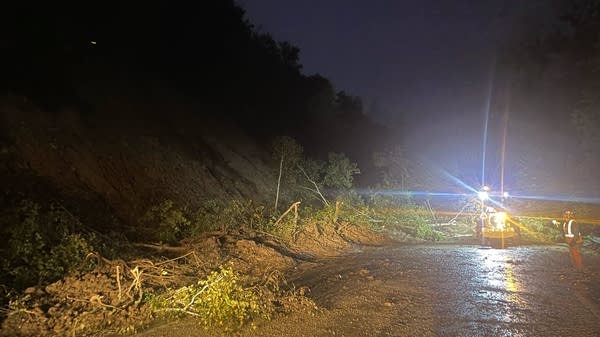
Mud, trees and other debris cover State Highway 16 between Lanesboro and Whalan in southeast Minnesota early Saturday.
Minnesota Department of Transportation
Larger rivers in the region continued rising through the day Saturday, as they absorbed storm runoff from creeks and streams.
In the city of Austin, rising waters on the Cedar River forced the closure of some streets late Saturday afternoon. The river was forecast to crest in moderate flood stage late Saturday or early Sunday.
“The city has roadblocks set up. DO NOT go around barricades. They are up for a reason,” the Austin Police Department posted on social media.
The Root River was forecast to reach minor flood stage at Lanesboro and Houston.
State Highway 16 was closed east of Lanesboro for several hours on Saturday morning after a rain-soaked hillside gave way, sending mud and debris across the road. The highway reopened by mid-morning, but flooding continued along the Root River.

A Minnesota Department of Transportation plow moves through an area where floodwaters, mud and debris covered State Highway 16 east of Lanesboro following torrential rain on Saturday.
Minnesota Department of Transportation
The Old Barn Resort between Lanesboro and Preston reported “severe” flooding of its riverside golf course, and said the course would be closed until further notice.
Other parts of the resort, and downtown Lanesboro, remained open Saturday.
The National Weather Service also received reports of mudslides overnight along State Highway 76 near Caledonia. Police in Hokah reported that floodwaters encroached on State Highways 16 and 44 in town, and that the area around Como Falls was closed Saturday morning.
Find updates on highway closures on MnDOT’s 511 website.
There were no immediate reports of injuries from the flooding.
Find forecast updates on MPR Weather’s Updraft blog.
Some of the communities affected by this weekend’s flooding also saw significant flash flooding earlier this year — on July 2, and again on July 8.