
As a Navy veteran, Tom Ellis had seen more impressive waves on the open seas — but not on the ocean in the popular barrier island town of Ocean City, N.J., that he and his wife, Pat, call home.
Standing on the music pier Thursday morning listening to the percussive sounds of whitecaps, stirred by Hurricane Erin, crashing on pilings and storm drain pipes, they watched in wonder and hoped that any flooding would kindly avoid the house on 27th Street they bought 30 years ago.
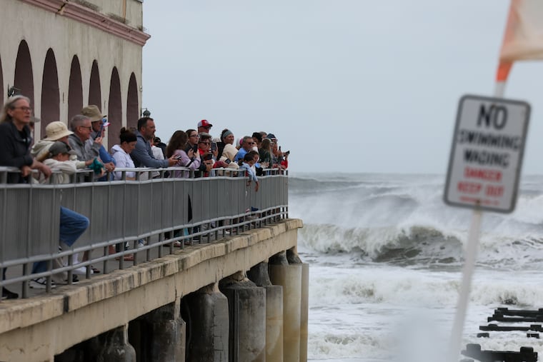
On an altogether dismal day, people lined the boardwalk railings to watch and capture video of what was keeping them off the beaches — the potent breakers generated by the season’s first hurricane.
“It’s the craziest I’ve seen it,” said Ahmed Helmy, who was observing the chaotic behavior of the Atlantic as he served customers at the packed Ocean’s South End Pizza on the boardwalk.
“You have to see it for yourself.”
On Thursday night, the Erin-related effects, with an assist from the new moon, became more than a spectator sport on parts of the Jersey Shore.
Flooding in Atlantic City led to multiple water rescues and more than 10 people were evacuated from flood-threatened homes, said Scott Evans, the city’s emergency management coordinator.
“We have a decent amount of road closures,” he added, including Routes 30 and 40.
Even before the approach of Erin, days of onshore winds had driven up water levels in the back bays, which became further congested with Erin-enhanced waves. Evans said the bay never really had a chance to drain after Thursday morning’s high tide, setting the stage for mayhem in the next go-round.
No injuries or deaths were reported in Atlantic City or elsewhere near the Shore, but numerous other road closings were reported in Cape May and Burlington Counties. Wildwood declared a state of emergency and ordered people to stay off the beach.
Earlier in the day, Gov. Phil Murphy declared a state of emergency for all 21 counties, citing the continuing threats of flooding, dangerous rip currents, and beach erosion. Rip currents were expected to be an issue into the weekend.
The waters in the Cape May County bay areas already had reached minor flood stage Thursday evening before the high tide, said Ray Martin, a lead meteorologist at the National Weather Service office in Mount Holly, and social media posts showed some water creeping onto the streets of Ocean City.
Flooding was reported along the boardwalk in the heart of town at 8th and 9th Streets, the weather service said.
.
The weather service was warning that “major” flooding was possible in Cape May.
Some Erin ripple effects were also expected in Philadelphia, with a coastal flood advisory in effect along the Delaware River from 11 p.m. Thursday to 5 a.m. Friday. “The low spots along the river could see some water,” Martin said.
What’s more, with water piled up in Delaware Bay, and winds due to switch around to the south, waters “might stay elevated on the river for several more days,” he added.
All that said, as of Thursday night, the Shore towns and rest of the region evidently had been spared the significant impacts and flooding that bedeviled parts of the North Carolina coast.
But officials were not quite ready to take down all the caution flags. The weather service has issued flood warnings for the entire coast until 2 a.m. Saturday.
Even as Erin was making a sharp right and heading well out to sea Thursday afternoon, it had come within about 350 miles of Cape May with peak winds of 100 mph that were continuing to act as a massive plunger in the North Atlantic.
Meteorologists and emergency management officials were warning that as it moved farther away, the aftereffects would ripple on; witness the nuisance flooding threat on the Delaware.
And Erin’s drive-by effects are getting an assist from that invisible force — the new moon.
The flood potential for the Shore and the Delaware River
After days of onshore winds that have been driving water into the congested bays through the inlets, Erin’s storm waves are further inhibiting drainage.
What’s more, the tides were getting a lift from the approaching new moon. Even though it’s not visible, its tugging effects are comparable to that of a full moon, since in both cases, the Earth, sun, and moon are aligned.
At least minor flooding was expected to persist at the Shore for two or three additional tidal cycles into early Saturday.
A combination of the moon’s influence and Erin’s storm waves was contributing to swelling the Delaware, said Eric Hoeflich, a weather service meteorologist in Mount Holly.
Road flooding, perhaps on Columbus Boulevard, was possible in Philly around the times of high tides at 1 a.m. and 2 p.m. Friday and 2 a.m. Saturday, the weather service says.
Beach erosion a certainty at the Shore
Whatever else does or doesn’t happen, Erin’s waves will have cost the beaches some sand.
“We won’t be able to assess erosion until the tides recede over the next couple days, but the storm will certainly erode all beaches to varying degrees,” said Ocean City spokesperson Doug Bergen.
Kimberly McKenna, interim director of the Stockton University Coastal Resources Center, said her team would be assessing the damages.
Fortunately, she said, the dune systems along the coast are in decent shape, and August typically is the time beaches are at their healthiest.
New Jersey has been battling to keep sand on its beaches for over a hundred years, and Ocean City has a long history of beach fills and assorted other beach-protection strategies.
In the last 25 years alone, the federal government has invested $733.7 million in beach fills and other shore-protection measures, according to Howard Marlowe, one of the nation’s most prominent coastal-development lobbyists.
That’s No. 2 in the nation just behind Florida — which has about 10 times more shoreline than Jersey. Illinois is a distant third at $170.2 million.
Coming very soon: Big improvements in the weather
When exactly the Atlantic Ocean will calm down and people can get back in the water remains to be seen.
However, the atmosphere is going to be on its best behavior.
Friday, Saturday, and Sunday are due to be mostly sunny with highs around 80 degrees at the Shore, and a few degrees warmer inland.
No other tropical storm or hurricane threats are imminent.
If they do happen, the Ellises say, they will accept whatever comes.
“You’re on an island. It’s going to happen,” Tom Ellis said. “But it’s nice down here. I enjoy it down here, especially after Labor Day, when the crowds leave.”