
Published Sept. 25, 2025 09:00 PM GMT+5:30
Landslides caused by heavy rain and previous typhoons
Barrier lake formed in the valley
Wall of water
flowing down
Major road bridge destroyed
Landslides caused by heavy rain and previous typhoons
Barrier lake formed in the valley
Wall of water
flowing down
Major road bridge destroyed
Many sought shelter on the higher floors of their homes
Landslides caused by heavy rain and previous typhoons
Barrier lake formed in the valley
Wall of water
flowing down
Major road bridge destroyed
Many sought shelter on the higher floors of their homes
Landslides caused by heavy rain and previous typhoons
Barrier lake formed in the valley
Wall of water
flowing down
Major road bridge destroyed
Many sought shelter on the higher floors of their homes
Landslides caused by heavy rain and previous typhoons
Barrier lake formed in the valley
Wall of water
flowing down
Major road bridge destroyed
Many sought shelter on the higher floors of their homes
Satellite image: Google © 2025 CNES/Airbus, Landsat/Copernicus, Maxar Technologies
Typhoon Ragasa, the world’s most powerful tropical cyclone this year, barreled towards tens of millions of people in southern China on Wednesday, September 24, after killing at least 14 people in Taiwan, leaving scores missing and lashing Hong Kong with ferocious winds and heavy rains.
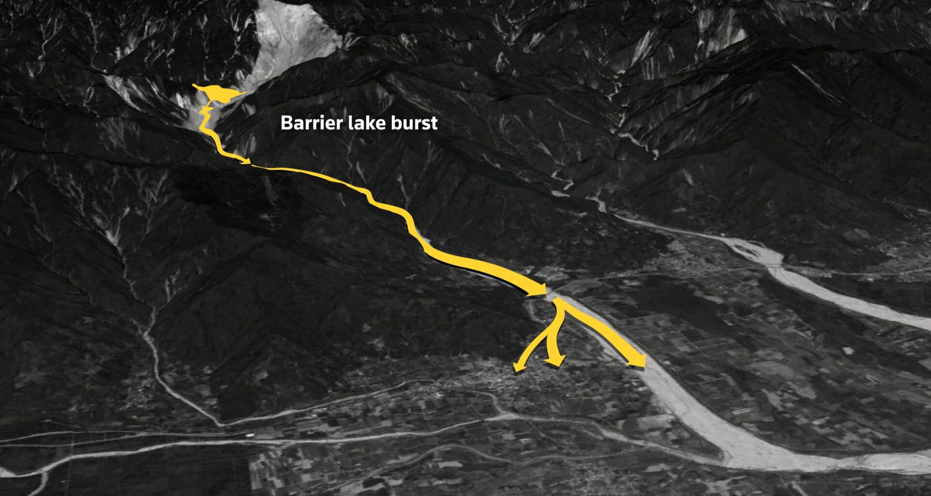
Many also went missing in Taiwan’s eastern Hualien county, after a barrier lake overflowed and sent a wall of water into a town, the Taiwan fire department said, with Ragasa’s outer rim having drenched the island since Monday, September 22.
How the barrier lake formed and grew
The lake was first discovered in July, having been formed when earlier typhoons caused landslides blocking a valley.
Three satellite images side by side. The first one shows the valley with no lake, the second shows the valley with the lake formed on July 25 and a month later on August 18, the lake is much bigger.
Barrier lakes are formed when rocks, landslides or other natural blockages make a dam across a river, normally in a valley, blocking and holding back water, hindering or even stopping natural drainage. This lake is in a remote part of the mountains above the town of Guangfu on a tributary of the Matai’an Creek.
A Reuters analysis of satellite imagery by Planet Labs shows that the lake first started forming sometime between July 17 and July 25. The surface area of the lake increased by about five times between July 25 and mid-September.
How big was the lake
A Reuters analysis of satellite imagery shows the lake grew to a size of 0.92 square km by mid-September.
A diagram of the lake showing its estimated dimensions on different dates from July to September.
Before it overflowed this week, the dam forming the lake stood approximately 120 metres (390 ft) high, with the water behind it covering an area 500 metres (1,600 ft) long, and 1,650 metres (5,400 ft) wide, according to the government.
It has since shrunk in size by about 75%. The government said the overflow released about 60 million metric tons from a barrier lake that held an estimated 91 million metric tons—enough to fill about 36,000 Olympic-sized swimming pools.
The water hit like a “tsunami”, said Guangfu postman Hsieh Chien-tung, who was able to flee to the second floor of the post office just in time. Later, he got home to find his car had been swept into the living room.
The overflowing river, caused by a burst barrier lake in eastern Taiwan, broke a bridge and flooded a nearby village on September 23. REUTERS
Typhoon Ragasa brought heavy rainfall
The mountainous region of Taiwan saw heavy rainfall, according to satellite analysis data.
This shows a map with rainfall patterns in circular motions along the typhoon path but also highlights a strong accumulation of rain along the mountains in Taiwan, where the lake burst.
Note: Data as of September 24, 0600 GMT.
The lake’s remote, hazardous location has hampered authorities’ efforts to lower the water level and clear the rubble.
Some parts of the mountains in Hualien remain unstable after a 7.2 magnitude quake hit the region last year, Taiwan’s biggest earthquake in at least 25 years.
A man stands near a military vehicle on a road filled with mud brought by flooding, after Super Typhoon Ragasa in Hualien, Taiwan, September 24, 2025. REUTERS/Ann Wang
Strongest storm of the year
Ragasa formed over the Western Pacific last week. Fuelled by warm seas and favourable atmospheric conditions, the tropical cyclone rapidly intensified to become a Category 5 super typhoon on Monday with winds exceeding 260 kph (162 mph).
It has since weakened, but was still powerful enough to bring down trees and power lines.
“Authorities have taken lessons from Hato and Mangkhut, which both caused billions of dollars in damage in 2017 and 2018,” said Chim Lee, a senior energy and climate change specialist at the Economist Intelligence Unit.
How Ragasa’s windspeed compares
Maximum sustained wind speeds (1-minute mean)
Category 4 and 5 typhoons in 2025
Days since first reached 100 kph speed
Category 4 and 5 typhoons that
made landfall in China in past decade
Days since first reached 100 kph speed
Category 4 and 5 typhoons in 2025
Days since first reached 100 kph speed
Category 4 and 5 typhoons that made landfall in China in past decade
Days since first reached 100 kph speed
Category 4 and 5 typhoons in 2025
Days since first reached 100 kph speed
Category 4 and 5 typhoons that made landfall in China in past decade
Days since first reached 100 kph speed
Category 4 and 5 typhoons in 2025
Category 4 and 5 typhoons that
made landfall in China in past decade
Days since first reached 100 kph speed
Days since first reached 100 kph speed
Category 4 and 5 typhoons in 2025
Category 4 and 5 typhoons that made landfall in China in past decade
Days since first reached 100 kph speed
Days since first reached 100 kph speed
There are two line charts. The first one shows how Ragasa has the strongest winds of 2025, compared with other category 4 and 5 cyclones. The second line chart compares it with other category 4 and 5 typhoons that made landfall in China, Ragasa is not as fast or as sustained as Meranti or Mangkhut.
Note: Data as of September 24, 1200 GMT. Day 0 refers to the point when the maximum sustained wind speeds reached at least 100 kph.
After passing around 100 km (60 miles) south of Hong Kong, Ragasa made landfall along the south Chinese coast. Guangzhou, Shenzhen, Foshan and Dongguan, the largest cities in the storm’s path, are home to around 50 million people.
More than 100 people were injured in Hong Kong, where authorities imposed the highest typhoon signal 10 for most of Wednesday.
Prior to Ragasa’s arrival, authorities handed out sandbags on Monday for residents to bolster their homes in low-lying areas, while many people stockpiled daily necessities, leading to bare supermarket shelves and surging fresh vegetable prices.
A woman walks past a tree toppled by Super Typhoon Ragasa in Hong Kong, China, September 24, 2025. REUTERS/Tyrone Siu
In the gambling hub of Macau, next to Hong Kong, casinos were forced to shutter their gambling areas. One user on China’s Xiaohongshu app showed videos of doors being sealed at a casino resort for protection against gales and debris.
Strong winds reached up to 280 kph
Add a description of the graphic for screen readers. This is invisible on the page.
Note: Data as of September 24, 0600 GMT.
Hong Kong’s Airport Authority said airlines would gradually resume flights starting from 6 a.m. (1000 GMT) on Thursday, with all three runways operating simultaneously.
More than 2 million people were evacuated across Guangdong and the ministry for emergencies dispatched tens of thousands of tents, folding beds, lighting equipment and other rescue supplies, Chinese state media reported.
Storm surges in Hong Kong, southern China
In Hong Kong, where huge waves crashed over areas of the Asian financial hub’s eastern and southern shoreline, some roads and residential properties were submerged.
At the Fullerton Hotel on the island’s south, videos on social media showed seawater surging through glass doors. No injuries have been reported, the hotel said.
China’s marine authority issued its highest red wave warning for the first time this year, forecasting storm surges of up to 2.8 metres (9 feet) in parts of Guangdong province, as Ragasa headed towards the densely populated Pearl River Delta.
Sea levels rose up to 3m along the coast
A high tide at the same time also impacted water levels.
A map of China, Hong Kong, Taiwan and the Philippines. There are yellow data points ranging from white for higher levels of water, to darker yellow for lower levels of water. Most of the area around southern Hong Kong, Macau and southern China show higher levels of water.
“We live on an upper floor and saw there wasn’t too much danger, so I brought the kids out to experience this heavy rain and wind,” a 40-year-old Shenzhen resident surnamed Liang said. “We walked along the open road to make sure to stay safe.”
A crowd chasing the storm under Shenzhen Bay Bridge was moved on by traffic police.
“The typhoon was really intense, but I’ve not been out long,” said an electric scooter delivery driver who goes by the name of Tim and was using his vehicle to assess the damage.
A woman and her 5-year-old son were swept into the ocean on Tuesday after watching the typhoon from the Hong Kong waterfront, according to the South China Morning Post, which said they were in intensive care.
A resident takes photos of rough waves from the shore before Super Typhoon Ragasa makes its closest approach to Hong Kong, China, September 23, 2025. REUTERS/Tyrone Siu
The typhoon injured at least 90 people, the hospital authority said, and the government opened 50 temporary shelters which provided refuge to 885 people.
On Thursday, the observatory maintained its second-lowest typhoon signal 3, keeping kindergartens and some schools shut as Ragasa moved away from the city and weakened into a tropical storm.
In Guangfu, Taiwan, soldiers operating from an armored personnel carrier to keep clear of thick mud in the streets went door-to-door handing out water and instant noodles. Wrecked cars and scooters lay abandoned in the mud.
As heavy rain continued on and off in Hualien, police cars sounded sirens for a new flood warning in Guangfu on Wednesday, sending people scrambling for safer areas as residents and rescuers shouted: “The flood waters are coming, run fast.”
Deputy disaster command center chief Huang Chao-chin said with rainfall easing and much of the water from the lake already released, he did not expect a repeat of Tuesday’s mass flooding.
Prasanta Kumar Dutta, Sudev Kiyada
Natural Earth; Global Disaster Alert and Coordination System (GDACS); International Best Track Archive for Climate Stewardship (IBTrACS); Joint Typhoon Warning Centre (JTWC)
Rebecca Pazos, Simon Scarr and Lisa Shumaker