
A nor’easter continues to bring a windswept rainfall to the Boston area, particularly right along the Massachusetts coastline. The WBZ weather team is extending a NEXT Weather Alert through early Tuesday.
As of Monday morning, 1-3″ of rain had already fallen across southeastern Massachusetts. Click here to see which towns have the most so far.

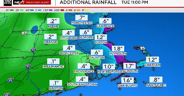
WBZ-TV graphic
CBS Boston
This area will continue to be the bullseye for the heaviest rain for the remainder of the storm.
We expect an additional 1″-2″ across most of eastern Mass. and .5″-1.0″ a bit farther inland.
Massachusetts Weather Radar
When will the rain and wind stop?
The rain will continue at varying intensity through Monday night and into early Tuesday.
The rain will taper to a drizzle/mist during Tuesday morning.
Winds have topped out between 40-55 mph across the coastal plain and in particular over far southeastern areas.
The National Weather Service has continued the wind advisory through 8 p.m. Monday night for the Cape and Islands.
Thankfully, the worst of the winds are behind us, and we will see a very slow, gradual decreasing of peak gusts in the next 24-36 hours.

WBZ-TV graphic
CBS Boston
Therefore, we expect only minor issues today with wind damage and power outages.
Coastal flooding
Coastal flooding has largely been minor thus far and we have one more high tide cycle to watch.
There will be minor inundation and splashover between 3 p.m. – 7 p.m. during the Monday evening high tide and the National Weather Service has issued a coastal flooding advisory for that timeframe.
Once this storm passes, the rest of this week looks pretty quiet. Temperatures will largely be below average with highs in the 50s and low 60s.