
Published Nov. 2, 2025 06:12 GMT
F-35 fighter jets
V-22 transport aircraft
KC-130 refuelling tankers
C-17 cargo transports
USNS Kanawha
USNS Joshua Humphreys
USS San Antonio
USS Wichita
MV Ocean Trader
USNS Waters
USS Stockdale
USS Iwo Jima
USS Gravely
USS Lake Erie
USS Stockdale
USS Iwo Jima
USS Gravely
USS Lake Erie
USNS Kanawha
USNS Joshua Humphreys
USS San Antonio
USS Wichita
MV Ocean Trader
USNS Waters
F-35 fighter jets
V-22 transport aircraft
KC-130 refuelling tankers
C-17 cargo transports
USS Stockdale
USS Iwo Jima
USS Gravely
USS Lake Erie
USNS Kanawha
USNS Joshua Humphreys
USS San Antonio
USS Wichita
MV Ocean Trader
USNS Waters
F-35 fighter jets
V-22 transport aircraft
KC-130 refuelling tankers
C-17 cargo transports
F-35 fighter jets
V-22 transport aircraft
KC-130 refuelling tankers
C-17 cargo transports
USNS Kanawha
USNS Joshua Humphreys
USS San Antonio
USS Wichita
MV Ocean Trader
USNS Waters
F-35 fighter jets
V-22 transport aircraft
KC-130 refuelling tankers
C-17 cargo transports
USNS Kanawha
USNS Joshua Humphreys
USS San Antonio
USS Wichita
MV Ocean Trader
USNS Waters
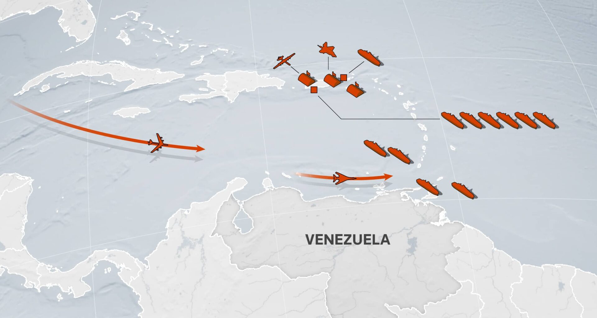
A map shows recent sightings of U.S. military vessels and aircraft in the Caribbean and off the coast of Venezuela.
Note: Recent sightings of U.S. military vessels and aircraft as of October 31.
Sources: Reuters reporting, MarineTraffic, FlightRadar24, Sentinel-2, Planet Labs PBC
The United States military is upgrading a long-abandoned former Cold War naval base in the Caribbean, a Reuters visual investigation has found, suggesting preparations for sustained operations that could help support possible actions inside Venezuela.
The construction activity at the former Roosevelt Roads naval base in Puerto Rico — shuttered by the Navy more than 20 years ago — was underway on September 17 when crews began clearing and repaving taxiways leading to the runway, according to photos taken by Reuters.
Until the Navy withdrew from the facility in 2004, Roosevelt Roads was one of the biggest U.S. naval stations in the world. The base occupies a strategic location and offers a large amount of space for gathering equipment, one U.S. official said.
In addition to the upgrades of landing and take-off capabilities at Roosevelt Roads, the U.S. is building out facilities at civilian airports in Puerto Rico and St Croix in the U.S. Virgin Islands.
The two U.S. territories sit roughly 500 miles from Venezuela.
Reuters spoke to three U.S. military officials and three maritime experts who said the new construction in Puerto Rico and the Virgin Islands pointed to preparations that could enable the U.S. military to carry out operations inside Venezuela. Venezuelan President Nicolas Maduro has repeatedly alleged that the U.S. is hoping to drive him from power.
“All of these things are, I think, are designed to scare the pants off the Maduro regime and the generals around him, with the hope that it will create fissures,” Christopher Hernandez-Roy, a senior fellow at the Center for Strategic and International Studies (CSIS) in Washington, told Reuters.
To monitor U.S. military activity in the region over the last two months, Reuters photographed U.S. military bases and reviewed satellite imagery, ship and flight tracking data and social media posts. The news agency also tracked movements of U.S. military vessels through on-the-ground reporting and open-source photos and videos.
The military buildup in the region is the largest unrelated to disaster relief since 1994, when the United States sent two aircraft carriers and more than 20,000 troops to Haiti to take part in “Operation Uphold Democracy.”
Since early September, the United States has carried out at least 14 strikes against alleged drug vessels in the Caribbean and Pacific, killing 61 people.
The strikes on alleged drug vessels have increased tensions with Venezuela and Colombia and drawn attention to a part of the world that has received limited resources within the U.S. military in recent years.
Asked for comment on the military expansion in the region, the White House said President Donald Trump had promised on the campaign trail to take on the region’s drug cartels.
“He has taken unprecedented action to stop the scourge of narcoterrorism that has resulted in the needless deaths of innocent Americans,” White House spokesperson Anna Kelly said in a statement to Reuters.
The U.S. military buildup in the Caribbean began in August with the arrival of warships, a nuclear-powered submarine, fighter jets and spy planes.
The Ford aircraft carrier strike group, with roughly 10,000 troops and dozens of aircraft and weapons systems, is on its way from the Adriatic Sea. One of the Ford’s destroyers cleared Gibraltar on October 29, according to satellite imagery and ship tracking data.
Presented with Reuters’ findings, the Pentagon did not respond to a request for comment. The governor of Puerto Rico did not respond to a request for comment.
Building up Caribbean bases
Some of the most dramatic infrastructure improvements are occurring at the former Roosevelt Roads base, where crews are upgrading taxiways with improvements that analysts say would enable use by fighter jets as well as cargo planes.
Mark Cancian, a retired U.S. Marine Corps colonel and senior adviser with the CSIS, said the changes were consistent with preparations for an increase in landings and takeoffs of military aircraft.
Former Roosevelt Roads military base
Former Roosevelt Roads military base
Former Roosevelt Roads military base
Former Roosevelt Roads military base
Former Roosevelt Roads military base
Satellite imagery shows improvements to a taxiway at the northern end of Roosevelt Roads in Ceiba, Puerto Rico.
Satellite imagery shows recent improvements to a taxiway at the northern end of the former Roosevelt Roads military base in Ceiba, Puerto Rico.
Sources: Google Earth / Airbus, Planet Labs PBC
In addition to the taxiway refurbishments, Reuters observed the installation of portable air traffic support and other mobile security equipment.
Satellite imagery taken on October 29 shows 20 new tents southeast of the runway near an abandoned aircraft hangar.
U.S. Marine Corps and U.S. Air Force aircraft and helicopters are parked at the former Roosevelt Roads military base in Ceiba, Puerto Rico, September 30, 2025. REUTERS/Ricardo Arduengo
Hernandez-Roy, the CSIS fellow, told Reuters it was possible that the U.S. military was simply repairing potholes. But he added: “If your focus is now going to be on Western Hemisphere, it makes perfect sense that you would want to reopen what was once a huge naval station and make sure that it can accommodate the range of airframes that the U.S. military uses.”
Former Roosevelt Roads military base
Former Roosevelt Roads military base
Former Roosevelt Roads military base
Former Roosevelt Roads military base
Former Roosevelt Roads military base
Satellite imagery and Reuters photography show new tents near the runway of the former Roosevelt Roads Naval Station in Ceiba, Puerto Rico, October 29, 2025.
Tents set up near the runway at the former Roosevelt Roads Naval Station, October 29, 2025.
Sources: Planet Labs PBC, REUTERS/Ricardo Arduengo
Reuters also found significant changes at Rafael Hernandez Airport, the second-busiest civilian airport in Puerto Rico.
By mid-October, the U.S. military had moved in communications gear and a mobile air traffic control tower — typically used to coordinate a surge of aircraft in war zones or after disasters.
Mobile air traffic control towers are used to coordinate a larger number of aircraft moving in and out of a region, according to military experts.
U.S. Air Force MQ-9 Reaper Drones
U.S. Air Force MQ-9 Reaper Drones
U.S. Air Force MQ-9 Reaper Drones
U.S. Air Force MQ-9 Reaper Drones
Satellite imagery and Reuters photography show reaper drones on the tarmac at Rafael Hernández Airport in Aguadilla, Puerto Rico in mid-October.
Satellite imagery and Reuters photography show reaper drones on the tarmac at Rafael Hernández Airport in Aguadilla, Puerto Rico in mid-October.
Sources: REUTERS/Ricardo Arduengo, Planet Labs PBC, Google Earth / Airbus
Satellite images show construction of an ammunition storage facility at the airport – although the experts Reuters spoke to said it was not immediately clear what weapons could be stored there.
“That’s very important,” Cancian said. “They could be used in the near-term for an operation against Venezuela.” But he acknowledged the facility could also signal long-term planning against counter-cartel operations.
On the nearby island of St. Croix, satellite imagery taken in September and October also shows construction activity at a civilian airport.
The images, from Henry E. Rohlsen Airport, show active construction near the apron, where planes are parked and serviced. Improving aprons could allow more U.S. military aircraft to park and refuel, the U.S. officials told Reuters.
Satellite imagery shows construction near the apron and what is likely a new radar system at Henry E. Rohlsen Airport in St. Croix, U.S. Virgin Islands.
Sources: Google Earth, Planet Labs PBC
A video filmed by a local resident at the request of Reuters shows a new radar system at the airport.
Albert Bryan Jr., the governor of the U.S. Virgin Islands, said in a statement through his office that while there was a level of coordination with the U.S. military over troop deployments on the territory, his office was not privy to operational details and future planning of those operations.
“He believes a regional presence of the U.S. military strengthens security and deters the trafficking of drugs and weapons through the territory,” the statement said.
Hernandez-Roy, with the CSIS, said the changes could be intended to support the large number of U.S. military aircraft coming into the region. The upgrades could also help plug gaps in radar surveillance capabilities, if drug traffickers turn from ships towards aircraft.
“The one gap in radar (coverage) that is a perennial problem for intercepting drug flights, is actually over Haiti, and it’s kind of like this big black hole,” Hernandez-Roy added.
According to the State Department, Haiti is used as a transit point to move cocaine and marijuana from South America to the United States.
The Haitian embassy did not immediately respond to a request for comment.
A video filmed on the island by a local resident at the request of Reuters shows a new radar system at the Henry E. Rohlsen Airport in St. Croix, U.S. Virgin Islands on October 30, 2025. Handout via REUTERS
Shipping in U.S. Naval firepower
According to Reuters reporting and U.S. officials, the Trump administration since August has deployed at least 13 warships, five support vessels and a nuclear submarine to the region from various naval bases and global deployments — including the Gerald Ford aircraft carrier, the largest vessel of its kind.
Eight warships remain in the region, along with supporting vessels.
MV Ocean Trader
Special Warfare Support vessel
Map showing the last tracked location of MV Ocean Trader as of
October 29, 2025 in the Caribbean at latitude 17.97255948 and longitude -66.61754164.
Ponce, Puerto Rico
Planet, Reuters analysis
An image of MV Ocean Trader at Ponce, Puerto Rico taken
October 29, 2025.
Ponce, Puerto Rico
REUTERS/Ricardo Arduengo
An image of MV Ocean Trader at Ponce, Puerto Rico taken
October 27, 2025.
84 miles from Venezuela
Sentinel-2, Reuters analysis
An image of MV Ocean Trader at 84 miles from Venezuela taken
October 16, 2025.
81 miles from Venezuela
Sentinel-2, Yörük Işık
An image of MV Ocean Trader at 81 miles from Venezuela taken
October 6, 2025.
78 miles from Venezuela
Sentinel-2, Yörük Işık
An image of MV Ocean Trader at 78 miles from Venezuela taken
October 4, 2025.
St Croix, USVI
Planet, Reuters analysis
An image of MV Ocean Trader at St Croix, USVI taken
September 25, 2025.
53 miles from Saint Kitts
MT Anderson, Sentinel-2, Yörük Işık
An image of MV Ocean Trader at 53 miles from Saint Kitts taken
September 20, 2025.
USS Gravely
Arleigh Burke-class (Flight IIA) Aegis guided missile destroyer
Map showing the last tracked location of USS Gravely as of
October 26, 2025 in the Caribbean at latitude 10.64648344 and longitude -61.51116103.
Port of Spain, Trinidad
Handout via REUTERS
An image of USS Gravely at Port of Spain, Trinidad taken
October 26, 2025.
11 miles from Puerto Rico
Sentinel-2, Yörük Işık, Reuters analysis
An image of USS Gravely at 11 miles from Puerto Rico taken
October 5, 2025.
Ponce, Puerto Rico
REUTERS/Ricardo Arduengo
An image of USS Gravely at Ponce, Puerto Rico taken
September 10, 2025.
USS Stockdale
Arleigh Burke-class (Flight IIA) Aegis guided missile destroyer
Map showing the last tracked location of USS Stockdale as of
October 20, 2025 in the Caribbean at latitude 12.936082 and longitude -63.589748.
Ponce, Puerto Rico
REUTERS/Ricardo Arduengo
An image of USS Stockdale at Ponce, Puerto Rico taken
October 4, 2025.
Ponce, Puerto Rico
Planet, Reuters analysis
An image of USS Stockdale at Ponce, Puerto Rico taken
October 3, 2025.
6 miles from Puerto Rico
MarineTraffic, Planet, Reuters analysis
An image of USS Stockdale at 6 miles from Puerto Rico taken
October 2, 2025.
Panama Canal
REUTERS/Enea Lebrun
An image of USS Stockdale at Panama Canal taken
September 21, 2025.
USS Iwo Jima
Wasp-class amphibious assault ship
Map showing the last tracked location of USS Iwo Jima as of
October 27, 2025 in the Caribbean at latitude 12.65173 and longitude -62.68848.
130 miles from Venezuela
Sentinel-2, MT Anderson, Reuters analysis
An image of USS Iwo Jima at 130 miles from Venezuela taken
October 27, 2025.
43 miles from Puerto Rico
Sentinel-2, Reuters analysis, Yörük Işık
An image of USS Iwo Jima at 43 miles from Puerto Rico taken
October 8, 2025.
St Thomas, USVI
Planet, Reuters analysis
An image of USS Iwo Jima at St Thomas, USVI taken
October 3, 2025.
Arroyo, Puerto Rico
REUTERS/Ricardo Arduengo
An image of USS Iwo Jima at Arroyo, Puerto Rico taken
September 22, 2025.
USNS Joshua Humphreys
Henry J. Kaiser-class replenishment oiler
Map showing the last tracked location of USNS Joshua Humphreys as of
October 15, 2025 in the Caribbean at latitude 17.97255948 and longitude -66.61754164.
Ponce, Puerto Rico
REUTERS/Ricardo Arduengo
An image of USNS Joshua Humphreys at Ponce, Puerto Rico taken
October 15, 2025.
Ponce, Puerto Rico
Planet, Reuters analysis
An image of USNS Joshua Humphreys at Ponce, Puerto Rico taken
October 12, 2025.
42 miles from Puerto Rico
Sentinel-2, Yörük Işık
An image of USNS Joshua Humphreys at 42 miles from Puerto Rico taken
October 8, 2025.
USS Lake Erie
Ticonderoga-class guided missile cruiser
Map showing the last tracked location of USS Lake Erie as of
October 30, 2025 in the Caribbean at latitude 17.97255948 and longitude -66.61754164.
Ponce, Puerto Rico
REUTERS/Ricardo Arduengo
An image of USS Lake Erie at Ponce, Puerto Rico taken
October 30, 2025.
86 miles from Venezuela
Sentinel-2, Reuters analysis
An image of USS Lake Erie at 86 miles from Venezuela taken
October 16, 2025.
79 miles from Venezuela
Sentinel-2, Yörük Işık, Reuters analysis
An image of USS Lake Erie at 79 miles from Venezuela taken
October 6, 2025.
82 miles from Venezuela
Sentinel-2, Yörük Işık, Reuters analysis
An image of USS Lake Erie at 82 miles from Venezuela taken
October 4, 2025.
Ponce, Puerto Rico
REUTERS/Ricardo Arduengo
An image of USS Lake Erie at Ponce, Puerto Rico taken
September 26, 2025.
Panama Canal
REUTERS/Mauricio Valenzuela
An image of USS Lake Erie at Panama Canal taken
August 31, 2025.
Panama Canal
REUTERS/Enea Lebrun
An image of USS Lake Erie at Panama Canal taken
August 29, 2025.
USS San Antonio
San Antonio-class amphibious transport dock
Map showing the last tracked location of USS San Antonio as of
October 30, 2025 in the Caribbean at latitude 17.71380079 and longitude -64.88852548.
St Croix, USVI
Handout via REUTERS
An image of USS San Antonio at St Croix, USVI taken
October 30, 2025.
47 miles from Puerto Rico
Sentinel-2, Yörük Işık
An image of USS San Antonio at 47 miles from Puerto Rico taken
October 8, 2025.
Ponce, Puerto Rico
REUTERS/Ricardo Arduengo
An image of USS San Antonio at Ponce, Puerto Rico taken
October 4, 2025.
Ponce, Puerto Rico
Planet, Reuters analysis
An image of USS San Antonio at Ponce, Puerto Rico taken
October 3, 2025.
USS Jason Dunham
Arleigh Burke-class (Flight IIA) Aegis guided missile destroyer
Map showing the last tracked location of USS Jason Dunham as of
October 19, 2025 in the Caribbean at latitude 18.33117083 and longitude -64.95363731.
St Thomas, USVI
Planet, Reuters analysis
An image of USS Jason Dunham at St Thomas, USVI taken
October 19, 2025.
Ponce, Puerto Rico
REUTERS/Ricardo Arduengo
An image of USS Jason Dunham at Ponce, Puerto Rico taken
September 6, 2025.
In addition, a former commercial vessel, the MV Ocean trader, has been observed docking in Puerto Rico and St. Croix and off the coast of Venezuela. While little information is publicly available on the MV Ocean Trader, it is widely believed by experts to be associated with U.S. Special Forces.
Brent Sadler, a maritime security expert with the Heritage Foundation, said the vessel was capable of deploying helicopters used by special forces and could also be used for landing forces.
Reuters identified the ship in satellite imagery 53 miles from Saint Kitts in late September but could not determine when the ship was deployed to the region. It was last observed docking in Ponce, Puerto Rico, at the end of October.
Three guided-missile destroyers — the USS Jason Dunham, the USS Gravely and the USS Stockdale — have also been deployed to the Caribbean.
And Reuters has spotted the arrival of support vessels including two refueling tankers, the USNS Kanawha and USNS Joshua Humphreys, a hospital ship, the USNS Comfort, and a submarine navigation-system testing vessel, the USNS Waters.
Air power off the Venezuelan coast
A ramp-up of U.S. military aircraft is also underway. Along with the Ford aircraft carrier, which can hold more than 75 military aircraft, the Pentagon has sent in 10 F-35 advanced aircraft and spy planes, according to previous Reuters reporting.
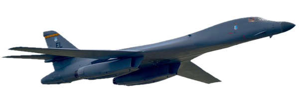
In late October, the U.S. Air Force flew supersonic Lancer bombers from Dyess Air Force Base in Abilene, Texas and Grand Forks Air Force Base in North Dakota off the coast of Venezuela, according to flight tracking data.
Rockwell B-1B Lancer flights
 VenezuelaUnited States
Oct. 23
Maps show the flight paths of three Rockwell B-1B Lancer flights from the United States to off the coast of Venezuela on October 23 and 27.
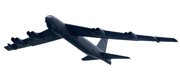
On October 15, three B-52 bombers took off from Barksdale Air Force Base in Shreveport, Louisiana, and circled off the coast of Venezuela before returning to base, according to flight tracking data.
Boeing B-52 Stratofortress flights
 VenezuelaUnited States
Oct. 15 Flight 1
Maps show the flight paths of three Boeing B-52 Stratofortress flights from the United States to off the coast of Venezuela on October 15.
The military is also shipping in materiel. Reuters tracked dozens of flights into the region by C-17 cargo aircraft. The experts interviewed by Reuters said the planes could be resupplying ships or bringing weapons systems or drones to the Puerto Rico base.
Boeing C-17 Globemaster III flights
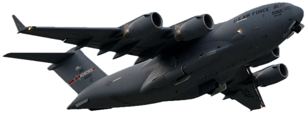
A map shows dozens of flights by C-17 military transport aircraft into the Caribbean region between September 3 and October 27.
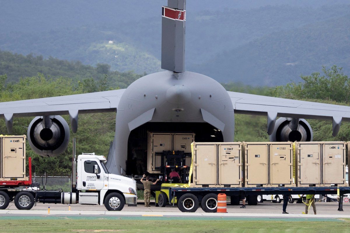
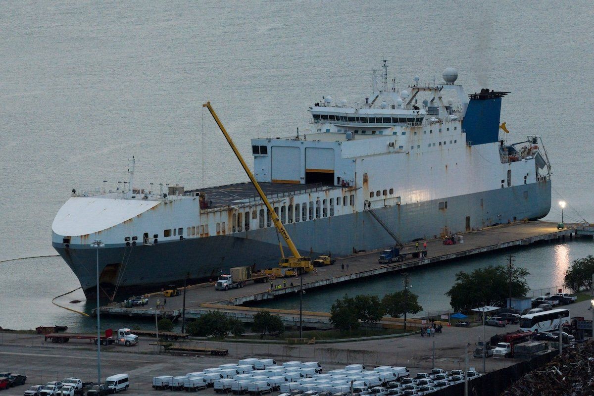
Crews load cargo onto a C-17 cargo aircraft at Mercedita International Airport (left) and a drone view shows the MV Ocean Trader (right) docked at the port of Ponce, Puerto Rico, October 27, 2025. REUTERS/Ricardo Arduengo
And at least a dozen spy aircraft from the U.S. Naval Air Station in Jacksonville, Florida, flew over the Bahamas and further south over the Caribbean in October, according to flight tracking data from FlightRadar24. Experts say these flights by Poseidon P-8A aircraft suggest the U.S. military is trying to gather large amounts of intelligence in the region.
Boeing P-8 Poseidon flights
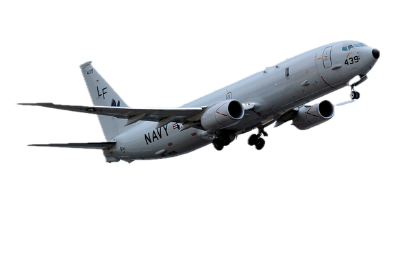
A map shows several flights by Boeing P-8 Poseidon aircraft between the United States and Puerto Rico in the Caribbean between October 2 and 21.
Note: Flight paths may include estimated segments where tracking data is unavailable.
Source: ADS-B Exchange
While the endgame of the massive buildup is not yet clear, the pieces are in place for operations inside Venezuela, something President Donald Trump suggested last Thursday.
“The land is going to be next,” he said.
Reuters reporting, Yörük Işık, MarineTraffic, FlightRadar24, Sentinel-2, Planet Labs PBC, Airbus DS
Sarah Cahlan, Jon McClure, Suzanne Goldenberg