
“The area has been isolated and power is being switched to essential supply while safety checks are completed.”
State Minister for Health Steve Edgington said he had spoken directly with the chief executive of NT Health who now has engineers on site assessing the structural integrity of the damaged area.
“Thank you to all the doctors, nurses and staff who are busy working on the frontline as we all feel the effects of Tropical Cyclone Fina,” he posted on social media.
Part of the roof at Darwin Hospital has collapsed during Tropical Cyclone Fina. Photo / Higgins Storm Chasing (Facebook)
The bureau reported gusts exceeding 200km at Melville Island, extending to Bathurst Island and with a chance of reaching Wurrumiyanga.
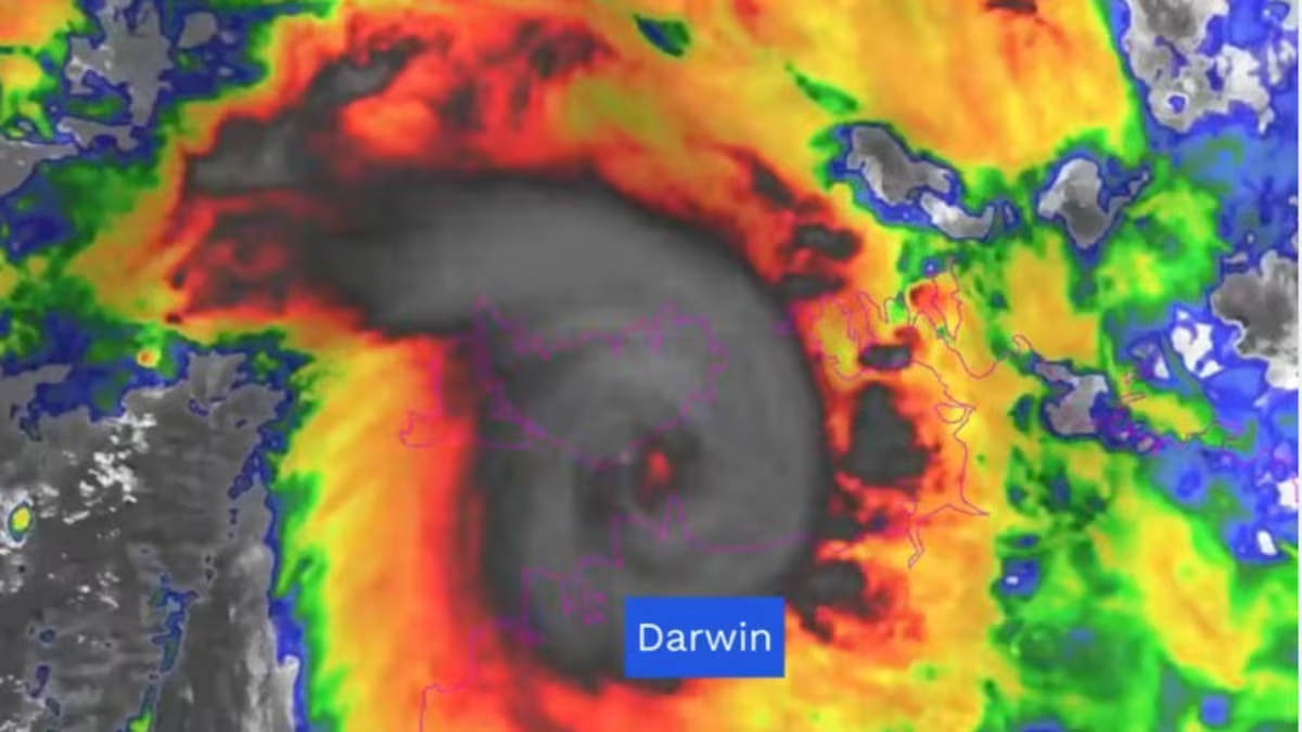
“Darwin radar and satellite imagery shows Fina just to the south of Melville Island as a small but intense system,” the bureau said.
“Based on Fina’s forecast west-southwest track, the very destructive core is likely to pass just north of Darwin.”
Destructive gusts could extend to the Darwin region in the next few hours, the bureau said, and possibly further to Dundee Beach on Saturday night (local time), particularly if Fina moves in a more southerly direction.
The storm is moving west-southwest at 8km per hour.
Swathes of the Northern Territory, including the Tiwi Islands and areas from Pt Stuart to Wadeye, which include Darwin, were under alert.
Residents on Tiwi Island were being warned to brace for wind gusts of up to 155km/h, with gale force winds over Melville Island, Darwin and Pt Stuart.
Gale-force winds were expected throughout the evening across the Tiwi Islands, and could extend to coastal parts of the north Kimberley Region in Western Australia, the bureau said.
The cyclone is expected to maintain severe tropical cyclone intensity through to early Monday before beginning to weaken.
NT Chief Minister Lia Finocchiaro said yesterday that the worst of the cyclone was expected to hit the Northern Territory at about 7pm.
“Certainly we’re bracing for a tough night,” Finocchiaro told NewsWire.
“Winds are certainly increasing, it’s quite gusty. It’s just been consistent rain all day.”
Australia’s Bureau of Meteorology (BOM) predicts the path of Tropical Cyclone Fina.
“We are expecting a rapid increase between now and the early evening, and with that all sorts of different things could happen. We would expect trees to be down, power maybe cut off in some areas,” she said.
“There’s going to be destructive winds experienced by thousands of Territorians.
“People just really need to stay safe, bunker down, and look after their family, friends and pets.”
Finocchiaro urged people to prepare their properties, including by removing or tying down loose objects, and to ensure they have 72 hours’ worth of supplies such as food, clean drinking water, torches and batteries.
“Everyone needs to be prepared, not panicked,” she said.
“We are in this together, and people need to be staying connected, listening to the authorities about what next steps are … heed all the warnings, stay safe, stay inside and look after yourselves, your families and your pets.”
She also thanked emergency services for their “exceptional” work in preparing for the cyclone, and sending out early, clear messaging.
“I just want Territorians to know we are in safe hands with our emergency management plan,” she said.
Winds could topple powerlines
Bureau of Meteorology meteorologist Jonathon How said damaging and destructive winds could topple powerlines and damage trees and property.
Flash flooding is also a possibility, he said, with up to 200mm of rainfall recorded in some coastal areas.
He said rainfall is expected to “really ramp up through the rest of the day” around Darwin.
Those in the path of the “dangerous” cyclone around the southern Melville Island and Cape Hotham to Pt Stuart were earlier urged to remain calm and seek secure shelter.
“Do not venture outside if you find yourself in the eye of the cyclone — destructive winds from a different direction could resume at any time,” the warning states.
The risk of Darwin experiencing very destructive wind gusts has been assessed as low, with the gusts likely to be about exposed coastal sites northeast of the city including Gunn Pt and Cape Hotham.
There’s a chance coastal parts north of the Kimberley in Western Australia, from Kalumburu to the WA/NT border, but not including Wyndham or Kununurra, may experience the gales.
The bureau has warned heavy to locally intense rainfall could bring on flash flooding along coastal areas between the Tiwi Islands and the Coburg Peninsula, with potential to extend to Darwin.
The warning zone now encompasses the Tiwi Islands and Cape Don to Wadeye, including Darwin, Cobourg Peninsula, Pirlangimpi, Milikapiti, Wurrumiyanga and Wadeye.
A watch zone has been declared from Wadeye (NT) to Troughton Island (WA) including Kalumburu (WA).
Generators pre-deployed
Federal Emergency Management Minister Kristy McBain warned on Friday that TC Fina could move “towards Darwin on Saturday night” and said she had been touch with the Northern Territory’s chief minister.
“Nema has already deployed officials into the area,” she told reporters in the National Situation Room in Canberra.
“We have implemented our National Co-ordination Mechanism and we are arranging a range of strategic planning issues.
“We remain ready to assist if there are any requests for assistance.”
She said authorities would remain eagle-eyed but asked anyone in the region to do their part too.
“It is really important now for community to listen to those emergency warnings from Secure NT, their emergency radio broadcasting channels, and we are asking community members to look out for vulnerable community members as well,” McBain said.
“It is really important that we heed the advice of our emergency authorities right now.”
She also said generators had been pre-deployed.
NTES earlier urged residents to enact their household emergency plans, secure property, monitor conditions via Secure NT and the Bureau of Meteorology, and take extra care on the roads.
The bureau earlier warned the intensity of the cyclone could severely increase today as it moves over the southern Timor Sea.
The bureau’s Angus Hines said damaging winds are forecast to hit between Cape Hotham and Warruwi, spanning the Coburg Peninsula, Minjalang and Gumballanya.
“We do expect those damaging winds to start in the next 24 hours, mostly through the second half of the day on Friday or into the early hours of the night into Saturday morning,” he said.
“Damaging winds will extend through those areas and could cause significant disruption, power outages, possible damage to property and trees as well. Rain will also kick in through that area.”
According to Weatherzone, category 2 cyclones typically produce wind gust speeds of 125km/h to 164km/h, while category 3 could see wind gusts between 165km/h to 224km/h.
Sign up to Herald Premium Editor’s Picks, delivered straight to your inbox every Friday. Editor-in-Chief Murray Kirkness picks the week’s best features, interviews and investigations. Sign up for Herald Premium here.