
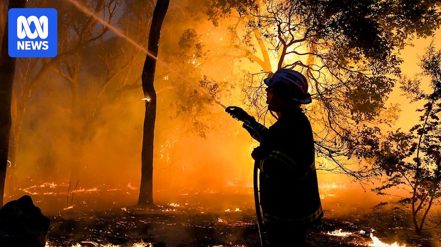
Fire authorities are warning some parts of Australia are likely to rapidly transition into a “highly flammable” state this summer as the effects of long-term severe dryness and a warm summer take hold.
It comes despite the Bureau of Meteorology (BOM) declaring a La Niña event is officially underway in the Pacific for the first time since 2023.
In its seasonal bushfire outlook, the National Council for Fire and Emergency Service (AFAC) identified increased risk of fires across parts of southern Western Australia and New South Wales.
Large parts of Victoria are also highlighted as having an increased fire risk later in the season, following long-term rainfall deficiencies in the region.
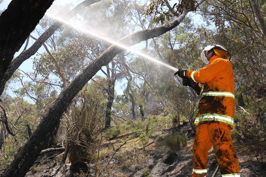
Fire authorities say even at normal risk level, dangerous bushfires can occur and residents should be prepared as conditions can change rapidly. (ABC News: Simon Goodes)
But recent rainfall has tempered fire risk in South Australia, which has also been battling drought conditions for the past two years.
AFAC chief executive Rob Webb said dangerous bushfires could happen even in places with normal fire risk, and preparations and plans should be made regardless.
“There’s a lot of bushland that people say ‘it’ll never happen’. Yet time and time again … it happens,” he said.
“Australia is a great place to be living. But we do get some pretty severe weather, and it’s worth treating that with respect and just finding out what can happen in your area.”
The BOM is forecasting hotter than average temperatures across almost the entire country this summer, with initial forecasts of slightly wetter than average conditions in the east no longer likely.
Summer grassfire warning for NSW
In NSW, forecasts of higher-than-average rainfall failed to eventuate this spring, leaving much of the landscape drier than expected heading into summer.
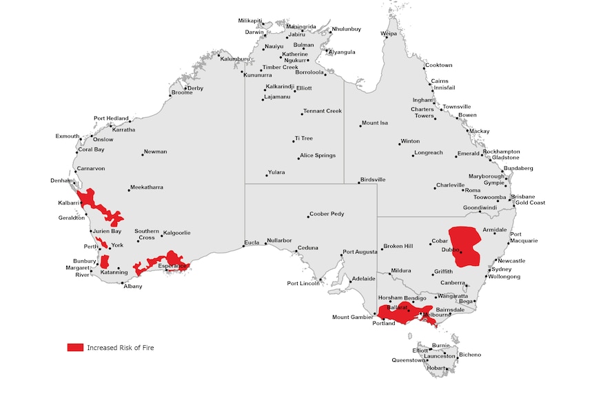
The Australasian Fire Authorities Council’s summer bushfire outlook is showing increased risk of fire in parts of Western Australia, New South Wales and Victoria. (Supplied: Australasian Fire Authorities Council)
It has led to increased fire danger across central and northern parts of the state where grasslands have the potential to support “intense, fast-moving fires”.
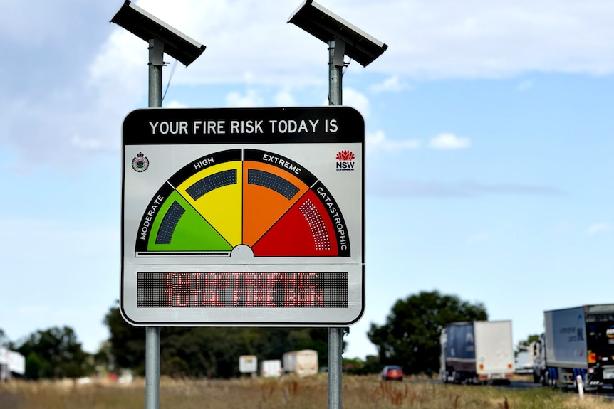
Already the state has seen a rapid switch into dangerous fire conditions, with dozens of schools closed on Wednesday as hot, dry weather saw the BOM issue its first catastrophic fire danger rating since 2023 for the Lower Central West Plains.
Large parts of the state remain at “extreme” fire danger level on Thursday, including Greater Sydney and the Hunter Valley.
Parts of the western slopes are also on the radar for fire authorities this summer, where “significant underlying dryness in some forested areas” could become more of a risk if rain does not come.
Catastrophic fire danger conditions were forecast in NSW on Wednesday (ABC Western Plains: Catherine James)
‘Highly flammable’ conditions in Victoria
In Victoria, spring rainfall has helped boost soil moisture and green growth across the southern parts of the state.
While this is likely to temper fire activity during December, fire authorities warn it is not expected to last.
They say severe long-term rainfall deficits across the region have left an “abundance” of dead, elevated vegetation — aka, fuel for fires — within forests and woodlands.
“It is highly likely that a hotter and drier pattern will lead to a rapid switch in forest flammability, with significant bushfires a real possibility in January and February,” the outlook said.
Significant grassfire potential is also likely across western and central Victoria where “abundant grass growth sits over very dry soil underneath”, according to the outlook.
Pockets of southern WA face fire risk
In Western Australia, increased fire risk is scattered across western and southern parts of the state.
It includes parts for the Swan Coastal Plain and Jarrah Forest regions, near Perth, and parts of the Esperance Plains where dry soil and older unburnt vegetation have increased the risk of fire.
The prospect of a warmer than average summer and drier than normal conditions have also increased the risk of fire within grassy woodlands and shrublands across the Yalgoo and Geraldton Sandplains.
Other parts of the country are marked as having “normal” fire risk, but there are warnings conditions can change rapidly in summer.
Hot summer on the cards
The BOM has also released its official outlook for summer, forecasting warmer-than-normal temperatures for almost the entire country, during both the day and the night.
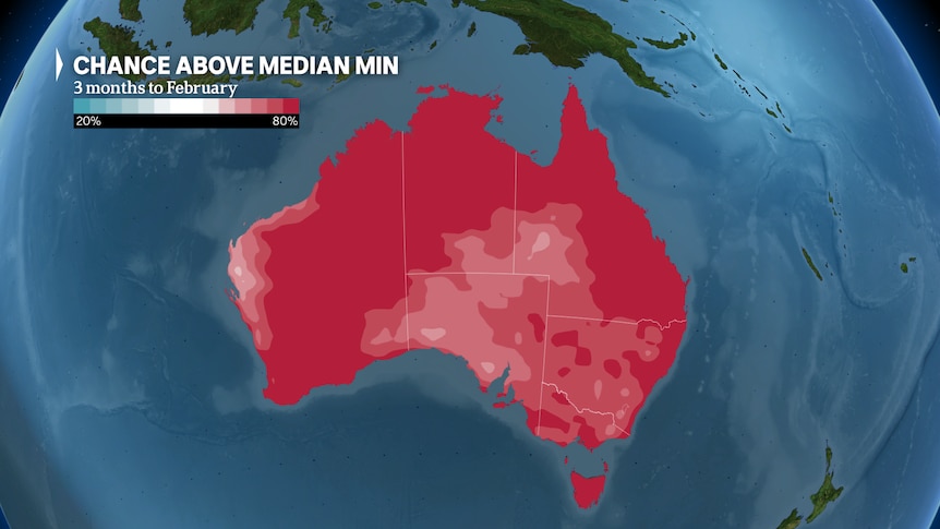
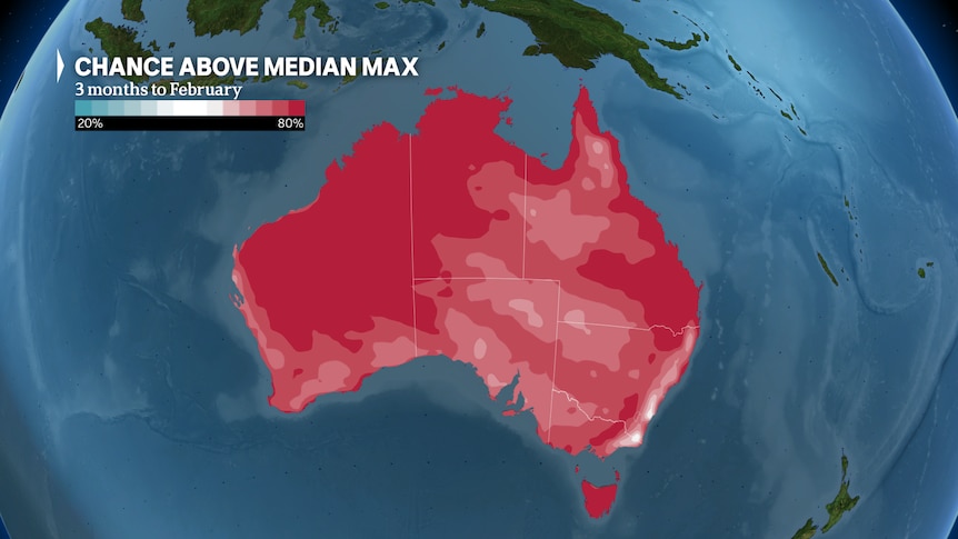 The chance of above average maximum temperatures for the summer months across the country. / The chance of above average minimum temperatures for the summer months across the country.
This signal of warmth is particularly prominent in states like Victoria, Tasmania, eastern Queensland and northern WA and the Northern Territory.
In those areas there is double to triple the chance of experiencing “unusually warm” summer time maximum temperatures, according to the forecast.
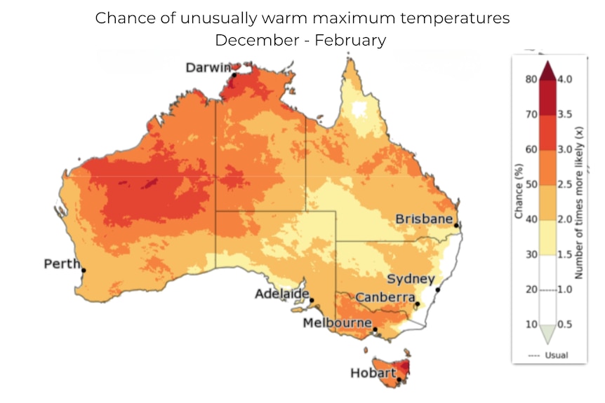
The outlook for summer is showing an increased chance of warmer than usual maximum temperatures across much of Australia. (Supplied: Bureau of Meteorology)
Large parts of northern Australia are also very likely to see unusually warm nights during the season.
BOM senior climatologist Simon Grainger said this was likely to increase the risk of heatwaves this summer.
“Heatwaves can be often very warm at night. So it’s all areas where there’s increased chance of daytime and night-time temperatures,” he said.
BOM declares La Niña summer
The BOM has officially declared a La Niña event is underway in the Pacific, a major climate driver typically associated with wetter conditions across large parts of Australia.
The last “triple dip” event, in 2021–2023, contributed to repeated, significant flooding across eastern Australia.
This does not appear likely for this year.
The summer outlook shows drier than normal conditions are likely to prevail during December for much of the country, including northern WA, South Australia, the NT and most of NSW.
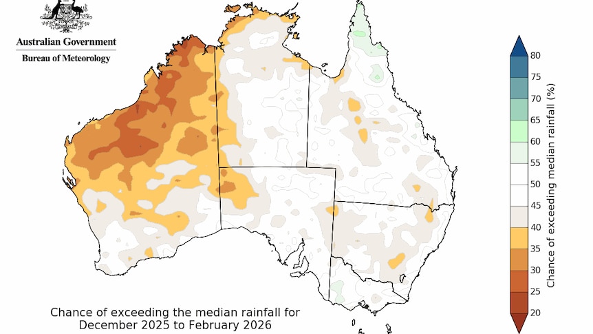
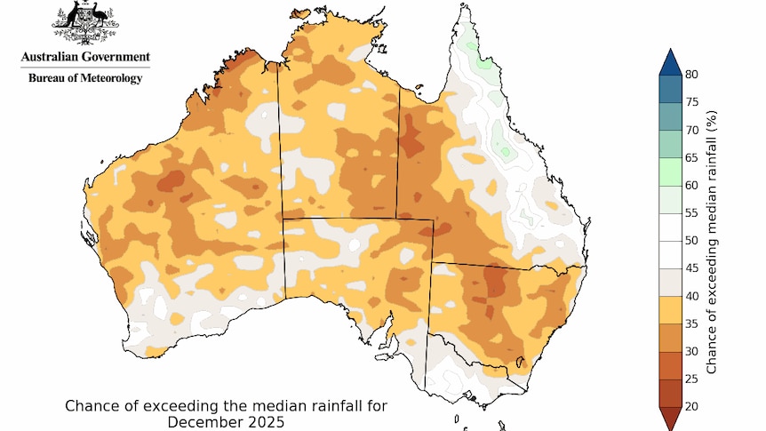 The December rainfall outlook shows drier than normal conditions are likely for much of the country. / The overall summer rainfall outlook shows a neutral forecast for much of the country, meaning there is an equal chance of above or below average rainfall.
This eases to more “neutral” odds for most of the country for the season as a whole, meaning there is an equal chance of there above or below average rainfall this summer.
Dr Grainger said while La Niña was active, the event was only expected to be “weak” and “short-lived”, meaning it had less of an influence on Australia’s weather.
He said there were also other climate drivers, like the Madden Julian Oscillation and the Southern Annular Mode, which seemed to be pulling the rainfall forecasts in the other direction.
“When we do have a weak La Niña it does mean that other climate factors can play a stronger role in Australian summer rainfall,” he said.
“So although there is a La Niña underway in the tropical Pacific, it’s weak, it’s likely to be short-lived and our rainfall forecast is currently suggesting it’s not the dominant influence on rainfall this summer.”
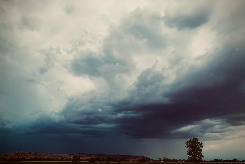
Heavy rain and severe storms have been lashing the east coast over the lat week. (Supplied: Weather Obsessed/Mandy O’Dea)
Earlier forecasts had initially indicated a slightly above average chance that summer would be wetter than normal in the east, but this has progressively got less likely as forecasts have been updated.
While a La Niña is active this year, it is likely to be short-lived, the bushfire outlook noted warm sea surface temperatures around much of the Australian coast may still enhance the severity of storms and weather systems, which carry flood and lightning risks.