
BOSTON — We’re on a WEATHER ALERT from the Boston 25 Weather Team due to winter storm warnings, watches, and advisories in our area.
Eastern Franklin, Northern Worcester, Northwest Middlesex County, Western Franklin, Western Hampshire, Western Hampden, Northern Berkshire, and Southern Berkshire are all under a winter storm warning through 7 a.m. Wednesday.
“Travel could be very difficult. The hazardous conditions could impact the Tuesday morning and evening commutes. Significant accumulation of wet, dense snow weighing on trees and powerlines could cause them to be downed,” the National Weather Service warned in the warning.
A winter storm watch is in effect for Eastern Franklin, Northern Worcester, Northwest Middlesex, Western Franklin, Western Hampshire, Western Hampden, Eastern Hampshire, Eastern Hampden, Southern Worcester, Central Middlesex, and Western Essex counties.
There is a winter weather advisory in effect for Central Middlesex County, Western Essex, Eastern Hampshire, Eastern Hampden, and Southern Worcester.
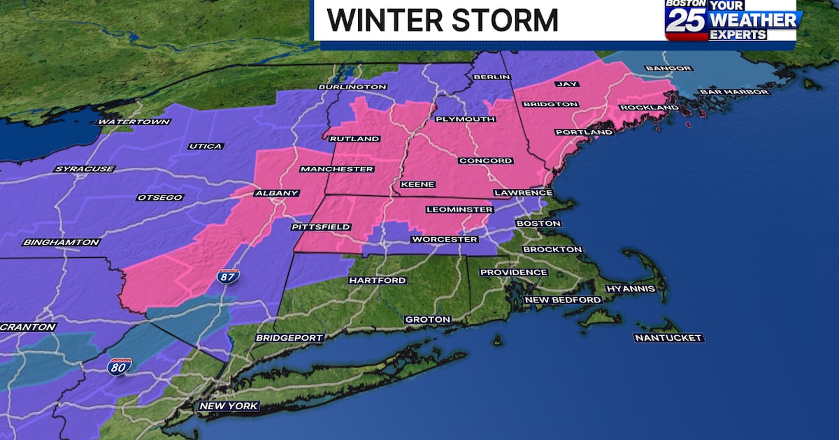
In a midmorning update on Monday, Boston 25 Meteorologist Shiri Spear updated her expected snowfall totals because the storm was “trending later and milder.”
According to Spear’s latest snow map, the best chance for accumulation will be at elevations and points to the north. There is a possibility of a coating of snow in Boston, but it won’t be until the tail end of the storm.
The Boston 25 Weather Team initially called for snow with totals in the range of 3 to 7 inches for interior towns north and west of I-495. Those areas will now likely see 1-3 inches.
Northern Massachusetts towns along the New Hampshire and Vermont borders could see 3-7 inches of snow, while northern New England is also in for up to 7 inches.
The South Shore, South Coast, Cape Cod, and the Islands will likely see just plain rain due to warmer temperatures.
Travel delays aren’t expected during the early morning commute, but road conditions are expected to deteriorate starting midmorning through the Tuesday evening commute.

A second round of snow and rain is possible this weekend.
WATCH THE FORECAST | INTERACTIVE RADAR | DOWNLOAD THE APPS
Follow our Boston 25 Meteorologists on Twitter for updates:
Kevin Lemanowicz | Shiri Spear | Tucker Antico | Vicki Graf
Stay Informed:
Utilize MEMA’s real-time power outage viewer to stay informed about current power outages in your community and region, and across the state, including information from utility companies about restoration times.
Utilize MEMA’s live weather radar and forecasting tools.
MassDOT | MBTA | Logan Airport | Amtrak
Online Resources:
Massachusetts Emergency Management Agency – on Facebook and Twitter
Federal Emergency Management Agency
National Weather Service/Boston
National Weather Service/Albany, NY
©2025 Cox Media Group