
Yellowstone Caldera Chronicles is a weekly column written by scientists and collaborators of the Yellowstone Volcano Observatory. This week’s contribution is from Scott K. Johnson, Science Communication Associate at EarthScope Consortium.
Just as we can sometimes fail to appreciate that fruits and vegetables don’t just magically appear in the produce section of our local grocery store, it’s easy to get accustomed to accessing important data, whether that’s for weather conditions or volcano monitoring. So indulge your curiosity—here’s a brief farm-to-table look the path GPS data take in order to track ground movement in and around Yellowstone.
We have to start in space, with the United States’ GPS satellites, as well as other Global Navigation Satellite System (GNSS) constellations. These satellites are a bit like 21st century town criers, given that they constantly orbit thousands of miles above the Earth and announce the time. GPS antennas and receivers on Earth are built to listen for those constant messages, using the extremely small difference between the very precise time in each satellite’s announcement as it reaches the receiving antenna to calculate how far away each satellite must be. Because the satellites also announce their position in each message, this gives us the ability to work out the antenna’s exact location on the Earth.
(As an aside, each satellite knows its position in space because of a complex network of satellite-tracking stations around the world, so there’s even more to this!)
The satellites transmit these announcements at radio-wave frequencies, which scientific GPS stations like the ones in Yellowstone pick up using specialized antennas that enable higher precision. That signal runs through a cable to the actual GPS receiver that records all the data.
GPS station P712 near the northwest corner of Yellowstone National Park. The gray dome on the left is the GPS antenna, the electronics are located in the brown boxes, and the small gray dome on the right is the satellite antenna used to transmit data to the online archive for processing and analysis. Photo by Scott Johnson, EarthScope Consortium, July 30, 2025.
The data then embark on the first leg of a network journey, either through a cell tower, a radio link, or a satellite connection back in orbit. Depending on the connection type, stations might record data every second or once every 15 seconds and then transmit the data either in real time or in less-frequent batches.
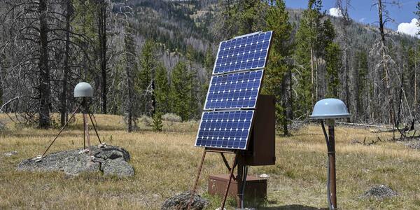
GPS station P714, located in Panther Meadow south of Mammoth Hot Springs in Yellowstone National Park. Photo by EarthScope Consortium, June 2008.
Years ago, all these data were sent to a single server room in Boulder, Colorado. More recently, however, cloud computing has taken over, so GPS data from receivers in Yellowstone and elsewhere are stored by the National Science Foundation’s National Geophysical Facility data archive, operated by EarthScope Consortium, on cloud servers. Once safely in the archive, a series of corrections can be applied, improving accuracy by accounting for sources of error like atmospheric conditions and tiny variations in satellite orbits.
Scientists and users can then access these data over the internet, from the raw satellite data to the daily averaged positions you see in charts on the Yellowstone Volcano Observatory website.
The GPS data from this Network of Americas, which outside of Yellowstone stretches from Alaska to the Caribbean, get used in many other ways, as well. On the West Coast, the real-time stream is used to detect earthquakes as quickly as possible—part of the ShakeAlert Earthquake Early Warning System. The error corrections also result in information about water vapor in the atmosphere and even space weather. And another way of looking at the data allows us to measure the height of snowpack around a station or the level of an adjacent body of water.
Knowing that a GPS station near the Norris Geyser Basin moved upward several millimeters in August (matching its typical seasonal motion) requires signals traveling thousands of miles down from orbit, out through terrestrial or space communications networks, and onto the internet where they might ping pong across the country a few more times before a chart appears on your screen.
That’s a lot of links in the chain! It also results in a lot of data—and a lot of work to keep that data flowing through the archive, from maintenance of field stations to upgrading computer archives and data processing algorithms. But just as the work to keep fresh produce on the shelves is worth it, complete and up-to-date GPS data are a must for effective monitoring of Yellowstone’s volcanic, tectonic, and hydrothermal systems.