
A winter storm that brings an Arctic blast, snow and ice to Oklahoma hits on Friday, and the wintry conditions will continue into the weekend. >> Go to the KOCO weather page | Get KOCO on the Go | Subscribe to KOCO 5’s YouTube channel | Sign up for KOCO 5’s Morning NewsletterKOCO 5 Chief Meteorologist Damon Lane says the snowfall totals are ramping up, and the sleet that is in the forecast will last a couple of hours. The winter storm is then changing over to snow, which will continue into Saturday with multiple waves. When will Oklahoma see ice and snow?There’s a low chance of a wintry mix by noon Friday, and the winter storm will move into more of the state, including the OKC metro, by 5 p.m. The wintry mix will continue Friday night, but our main wave is going to come in between 5 and 10 p.m. That wave will include sleet and snow, with northern Oklahoma getting the bulk of the snow. The snow and wintry mix will continue into Saturday morning, but there will be a little lull in the action during the early afternoon. A second wave of winter weather will hit by 7 p.m. Saturday, and the final wave of snow will hit by 10 p.m. This is going to be our heaviest snow. Oklahoma Snow OutlookSnowfall totals continue to increase as the winter storm approaches Oklahoma. We’re now looking at 10-14 inches of snow in west-central Oklahoma east of Clinton and up to the northern half of the state. The Oklahoma City metro is included in that zone. A band from Altus to Lawton, Norman, Pauls Valley, Ada, McAlester to the Arkansas border as well as northwestern Oklahoma near Woodward and Buffalo could get 6-10 inches. Southern Oklahoma and the Panhandle could get 4-6 inches. Oklahoma Sleet OutlookThere will be sleet beneath the snow, and a lot of the sleet happens Friday night and throughout the day on Saturday. The heaviest bands of sleet will accumulate in southern and southeastern Oklahoma. Those areas could get 1-2 inches of ice on roads. The further north you go, the less ice there will be on the roads. Oklahoma Road and Travel ImpactOklahomans will start seeing issues on the road on Friday. Slick spots are expected on roads in western Oklahoma, the OKC metro and east-central Oklahoma by 5 p.m. Friday. Road conditions will become more hazardous on Saturday. Sleet will leave a sheet of ice on roads in southern Oklahoma, and northern and southwestern Oklahoma will have snow-covered roads. That will change Sunday morning. Most of the state outside of far western Oklahoma will have dangerous road conditions because of the heavy snow. Oklahoma School Closings Several school districts have canceled classes for Friday in anticipation of the winter storm. Metro-area districts – including Oklahoma City, Norman, Edmond, Moore – are closed on Friday. You can find a full list of school closings here. KOCO 5 First Alert Weather Team, led by Chief Meteorologist Damon Lane, has been certified by WeatheRate as providing the Most Accurate Forecast in Oklahoma City for 13 consecutive years. This outstanding achievement underscores KOCO 5’s unwavering dedication to delivering reliable weather forecasts to viewers.
A winter storm that brings an Arctic blast, snow and ice to Oklahoma hits on Friday, and the wintry conditions will continue into the weekend.
>> Go to the KOCO weather page | Get KOCO on the Go | Subscribe to KOCO 5’s YouTube channel | Sign up for KOCO 5’s Morning Newsletter
KOCO 5 Chief Meteorologist Damon Lane says the snowfall totals are ramping up, and the sleet that is in the forecast will last a couple of hours. The winter storm is then changing over to snow, which will continue into Saturday with multiple waves.
When will Oklahoma see ice and snow?
There’s a low chance of a wintry mix by noon Friday, and the winter storm will move into more of the state, including the OKC metro, by 5 p.m.

The wintry mix will continue Friday night, but our main wave is going to come in between 5 and 10 p.m. That wave will include sleet and snow, with northern Oklahoma getting the bulk of the snow.

The snow and wintry mix will continue into Saturday morning, but there will be a little lull in the action during the early afternoon.

A second wave of winter weather will hit by 7 p.m. Saturday, and the final wave of snow will hit by 10 p.m. This is going to be our heaviest snow.

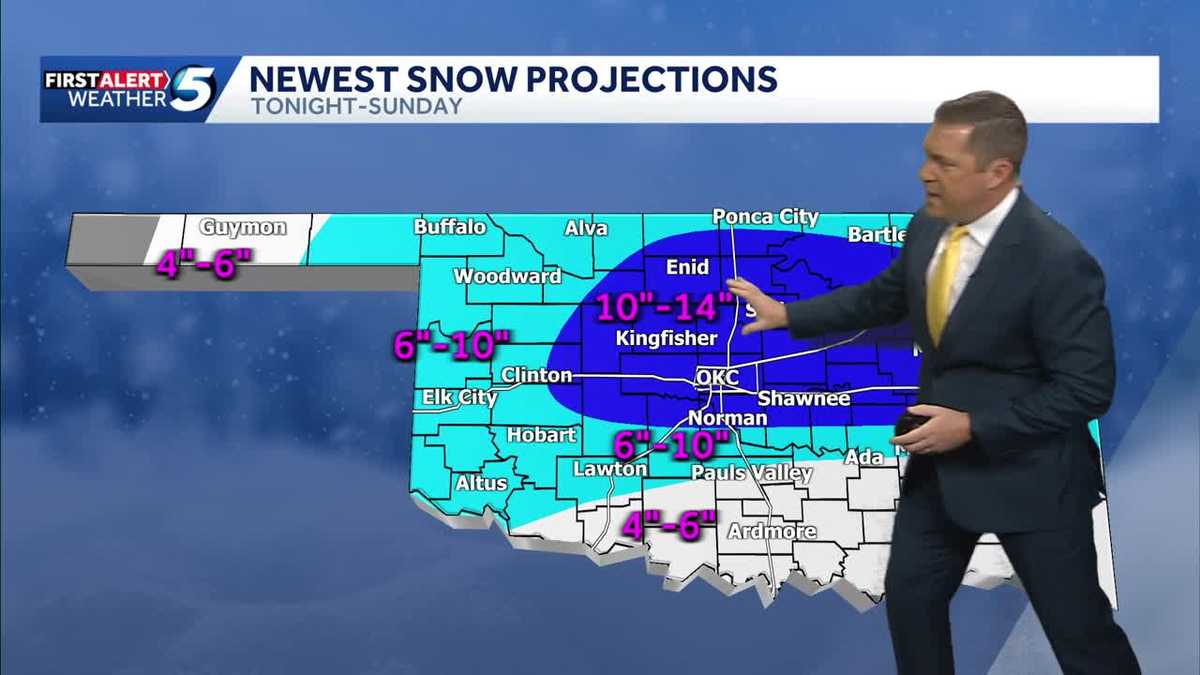
Oklahoma Snow Outlook
Snowfall totals continue to increase as the winter storm approaches Oklahoma.
We’re now looking at 10-14 inches of snow in west-central Oklahoma east of Clinton and up to the northern half of the state. The Oklahoma City metro is included in that zone.
A band from Altus to Lawton, Norman, Pauls Valley, Ada, McAlester to the Arkansas border as well as northwestern Oklahoma near Woodward and Buffalo could get 6-10 inches. Southern Oklahoma and the Panhandle could get 4-6 inches.

Oklahoma Sleet Outlook
There will be sleet beneath the snow, and a lot of the sleet happens Friday night and throughout the day on Saturday.
The heaviest bands of sleet will accumulate in southern and southeastern Oklahoma. Those areas could get 1-2 inches of ice on roads. The further north you go, the less ice there will be on the roads.

Oklahoma Road and Travel Impact
Oklahomans will start seeing issues on the road on Friday. Slick spots are expected on roads in western Oklahoma, the OKC metro and east-central Oklahoma by 5 p.m. Friday.

Road conditions will become more hazardous on Saturday. Sleet will leave a sheet of ice on roads in southern Oklahoma, and northern and southwestern Oklahoma will have snow-covered roads.

That will change Sunday morning. Most of the state outside of far western Oklahoma will have dangerous road conditions because of the heavy snow.

Oklahoma School Closings
Several school districts have canceled classes for Friday in anticipation of the winter storm. Metro-area districts – including Oklahoma City, Norman, Edmond, Moore – are closed on Friday.
You can find a full list of school closings here.
KOCO 5 First Alert Weather Team, led by Chief Meteorologist Damon Lane, has been certified by WeatheRate as providing the Most Accurate Forecast in Oklahoma City for 13 consecutive years. This outstanding achievement underscores KOCO 5’s unwavering dedication to delivering reliable weather forecasts to viewers.