
What are meteorologists supposed to do when the computer models they rely on disagree sharply with less than 48 hours to go before the start of a potential blockbuster storm?
That’s the supremely uncomfortable position that forecasters are in on Friday, as two of the mainstay computer models – the American Global Forecast System (GFS), and the European model, plus others, continued to argue over the intensity and track of a Mid-Atlantic and New England winter storm that starts Sunday.
The differences between the two major models, along with other forecast guidance, equates to the difference between a paralyzing blizzard along the I-95 corridor and a largely forgettable bout of light snow.
Given the costs of major snowstorms in the megalopolis between Washington, DC, and Boston, an accurate forecast could be worth hundreds of millions of dollars or more in this situation. Lack of preparation for a big storm could cost even more.
In this case, the reasons for the starkly diverging computer model solutions can be traced to subtle shifts in how they each handle pieces of atmospheric energy diving south out of Canada, rippling along the southern jet stream near the Gulf Coast, and a high pressure area, or bulge in the jet stream, over the Rockies.
In weather, the subtlest differences in depictions of the same atmospheric features can mean the difference between an all-out blizzard in the densely populated region from DC to Boston, versus a light to moderate snowfall. If all the ingredients come together in the right way, then boom! A major East Coast storm. If just one or two of the features are off in their timing or positioning, then a big storm would be far less likely.
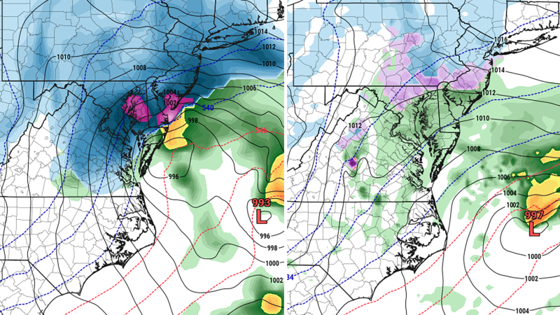
For the past few days, the GFS has insisted on a near-record snowstorm for Washington, DC, and other parts of the Mid-Atlantic, with a veritable bomb cyclone tracking north-northeastward close to the coast.
The Euro model, on the other hand, has consistently shown a much weaker storm tracking farther away from the coastline, bringing much lighter snow to the big cities.
The differences could not be starker and are unlikely to be explained by DOGE-related cuts in staffing at the National Weather Service or the resulting gaps in weather balloon data. After all, the GFS and the Euro rely on the same observations to make their projections, yet they are predicting radically different outcomes.
Early on Friday morning, the Euro model was projecting that Washington, DC, would receive about 4 inches of snow from this event, compared to the 18 inches put down by the GFS model.
The forecast nightmare is even worse in Philadelphia, where the Euro model shows just 1.7 inches of snowfall, compared to a whopping 29.2 inches from the GFS.
And while the advent of AI models is giving forecasters more tools in their toolbox for making accurate predictions, they are not solving this forecasting conundrum. Forecasting is far more complex than simply picking a model and regurgitating what it says verbatim. If that was all that was involved in it, there would be many more forecasters, and many more inaccurate forecasts.
To create an accurate forecast, meteorologists must understand why models are showing what they are showing, and they need to use their own expertise, considering far more factors than just these two competing models.
Cody Snell, a meteorologist at the NOAA Weather Prediction Center, said experts there are looking at all the data that is possible and then focusing their messaging on the potential impacts of the storm rather than specific snowfall amounts. Many good meteorologists do this, which is why you often see a potential range of snowfall amounts in your forecast, rather than a specific number. The best forecasters will tell you what the uncertainties are, and how confident they are in what they’re predicting.
“We look at every model, every ensemble system available to us, and usually the answer is somewhere in between,” Snell said. “We need to use all the guidance available to come up with a good message about the storm. And that’s the main thing, is coming up a good message versus the specific snow amounts.”
He said he and his colleagues are trying to avoid getting sucked into the computer model battles and keep the big picture in mind.
“Clearly you want certainty; you want all the models to agree, and you can speak with confidence that this is the scenario that’s going to occur,” Snell said. “But whenever there’s differences, especially with this population in play along the northeast, you just have to take into account all the possibilities.”
Also factoring into the current situation is the track record of the two main warring models: the Euro and its AI-powered cousin have performed far better this winter than the GFS, leading many to have profound doubts about the American model’s blockbuster scenario.
Typically, when the GFS and Euro disagree, forecasters stick with the Euro due to its past performance.
But those doubts notwithstanding, no other recent storm better illustrates the model differences that can persist almost through a storm’s start time.
In situations like these, meteorologists tend to split the difference between the two model camps and call for a light to moderate snowfall with the potential for much more. But in such situations the public messaging can become garbled, with people taking away huge ranges in snowfall, say from 4 to 18 inches, even though the experts see the high-end amount of 18 inches as a low probability, high impact outcome.