
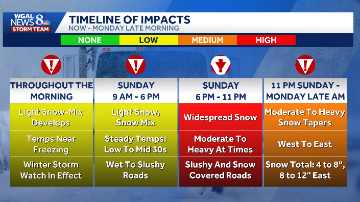
A major snowstorm is expected to hit South-Central Pennsylvania Sunday into Monday.The heaviest accumulations are expected after sunset on Sunday with precipitation ending by Monday (noontime in eastern counties, earlier in western counties).Timing — key hoursToday morning–late afternoon: rain/snow mix for much of the region; mixing decreases late afternoon and evening (around 6 p.m. expecting mainly snow).Tonight (after sunset): moderate to heavy snow picks up with the largest accumulation window overnight into early Monday.Early Monday: snow ending first in western counties (~8–9 a.m.) and tapering by about noon in eastern counties.Monday night: partial clearing.Snow totals and whereMost of South‑Central PA: 4–8 inches.Higher totals (8–12 inches) likely in parts of Lancaster, Lebanon and toward Philadelphia.Many spots will be near the 4–5 inch range.ImpactsRoads wet to slushy today, becoming snow‑covered this evening and overnight.Winds increase tonight and especially tomorrow — expect blowing snow, reduced visibility and difficult travel.High‑impact storm: plan on significant travel disruptions through Monday.What to do nowDelay nonessential travel tonight into Monday morning if possible.Allow extra time, charge devices, and secure outdoor items.
A major snowstorm is expected to hit South-Central Pennsylvania Sunday into Monday.
The heaviest accumulations are expected after sunset on Sunday with precipitation ending by Monday (noontime in eastern counties, earlier in western counties).
Timing — key hours

Today morning–late afternoon: rain/snow mix for much of the region; mixing decreases late afternoon and evening (around 6 p.m. expecting mainly snow).Tonight (after sunset): moderate to heavy snow picks up with the largest accumulation window overnight into early Monday.Early Monday: snow ending first in western counties (~8–9 a.m.) and tapering by about noon in eastern counties.Monday night: partial clearing.Snow totals and where

Most of South‑Central PA: 4–8 inches.Higher totals (8–12 inches) likely in parts of Lancaster, Lebanon and toward Philadelphia.Many spots will be near the 4–5 inch range.Impacts

Roads wet to slushy today, becoming snow‑covered this evening and overnight.Winds increase tonight and especially tomorrow — expect blowing snow, reduced visibility and difficult travel.High‑impact storm: plan on significant travel disruptions through Monday.

What to do nowDelay nonessential travel tonight into Monday morning if possible.Allow extra time, charge devices, and secure outdoor items.