
This winter in the UK will be chalked up relatively unremarkable – mild-ish, wet-ish and rather dull.
Is that how it felt to you? No, me neither! For many, it has felt relentlessly chilly, miserably wet and soul-sappingly interminable. Here’s the true picture that has been lost in the averaging out of one of the most peculiar winters in recent memory.
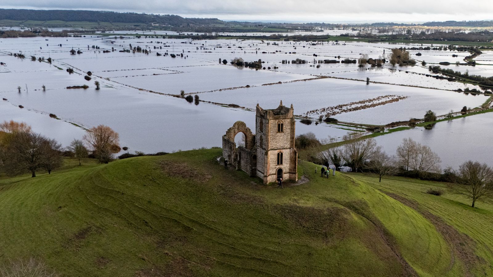
How wet was it really?
The Met Office conclude nine percent more rainfall than average fell; “wetter than average, but nowhere near record-breaking territory”, it said.
Dig a little deeper and the numbers put England as the wettest nation; 35% above the winter long term average, followed by Northern Ireland at 25% above, then Wales at 14% above and, astonishingly Scotland falling 16% below its expected winter rainfall.
A Boots van stuck in a flooded ford in Watery Gate Lane, Thurlaston, Leicestershire. Credit: AP
But how can that be when Cornwall and Dorset have just experienced one of their wettest winters on record with nearly double their average rainfall, and Bodmin in Cornwall seeing an astonishing 55 consecutive days of rain?!
Close to record-breaking rainfall too for County Down, the Isle of Wight, Angus, Kincardineshire, Hampshire and Aberdeen – who alone saw again, getting on for double their expected rainfall.
Subscribe free to our weekly newsletter for exclusive and original coverage from ITV News. Direct to your inbox every Friday morning.
So how can it be far from record-breaking with these kinds of totals?
The answer lies at the root of what is actually so remarkable about this winter; it’s the bizarre and extremely unusual distribution of rain.
Our winters usually follow a pattern of rain arriving from the west, crossing the UK and then heading away from us across the North Sea.
Being exposed to these rain-bearing Atlantic frontal systems first means that western parts usually bear the brunt of the short, sharp bursts of heavy rain, less so across more central and eastern areas and the south coast. So high rainfall amounts in these areas? That would be normal and average for them.
A fallen tree blocks Hall Lane in Houghton-le-Spring in Durham. Credit: PA News
But look at this map and notice the darkest blues where the heaviest of rain has fallen; eastern Scotland, eastern parts of Northern Ireland. traditionally sheltered parts of both the south coast and central England. And now look at western Scotland! It’s brown (and dry!) where it should be blue (and wet!).
Basic mathematics dictates that to get the average, (the total rain divided across the number of weather stations), the very dry goes a long way to balance out the very wet leaving us with a figure that is far and away from someone’s lived experience of the past three months!
Is the same true for sunshine?
Yes! Again the distribution of sunshine is highly irregular. 25 days without any recordable sunshine at all in Aberdeen for example, which would usually be far brighter than its more westerly cities is far from usual.
What about temperatures? It certainly didn’t feel mild and yet the data shows that it was!
Here’s another story that is lost in the averaging out. Yes it felt chilly by day, in large part down to the lack of sunshine – but how many times did you have to scrape your car in the morning? For many of us, the answer is ‘not many’. Yes there were some spells of snow for some – but this fell in areas that we would usually expect it – the high ground in the north.
Further south, to have only a handful of frosty nights and icy mornings – that’s a sign that it was our nights that were mild – and it’s that temperature that pulls up the overall winter average.
So what was the reason that things were so different this year?
I mentioned above that our usual pattern is rain-bearing Atlantic frontal systems bringing in rain from the west and then clearing east, usually easing and fragmenting as it cleared away.
This year, however, a huge area of high pressure has sat out to the east of us effectively blocking the clearance of those rain-bearing fronts. Essentially, with systems stalling over the UK, rain has been fast to arrive and slow to leave.
We’ve also had to contend with a ‘powered up jet stream’ which acts as a conveyor belt for frontal systems. This fast-moving current of air in the upper atmosphere has been supercharged over the last few months thanks to a much starker than usual temperature contrast across the USA as a result of some exceptional winter snow storms.
So the rain that has arrived across the UK has been both heavier and slower to clear.
And there’s one more crucial difference this year. That jet stream that has been firing rain bearing Atlantic systems at us? It’s been what forecasters term ‘south-shifted’ – those fronts, usually on course for western areas, have instead fed in on a more south/southeasterly wind.
And, now, if you look at those maps again and imagine cloud bearing, rain bearing frontal systems coming in from the south/southeast rather than the west, it starts to make sense. Remember too that a south/southeasterly airflow is also less cold than one from the north (the Arctic) and all those frost free nights start to make sense too.
If so much is lost in averaging, what’s the point?
The Met Office averages data to show the overall climate trend across the UK, allowing scientists to compare seasons and years consistently. Think of it like a school report; if the whole class averages 70%, it doesn’t mean every student scored 70% — some got 90%, some 50% but it gives a general overview of progress or decline. The average highlights big-picture patterns, tracks long term trends and allows a like-for-like comparable from one year to another. What the national figures can’t tell however is the lived experience of a particular area.
So how much was this winter down to climate change?
The Met Office have said that ‘while this winter’s weather has been heavily influenced by natural variability and atmospheric patterns, climate change provides important context.’
A warmer atmosphere holds more water; essentially when it rains, it now rains more. This winter might be explained by natural variability in weather patterns – but it unfolded in a climate that is now warmer than in the past. There is no doubt that future UK winters are expected to feature more days with significant rainfall making wet winters increasingly common in the long term.
For now though, it’s officially spring at last! And, come rain or shine, that’s surely something to smile about!
Have you heard our podcast Talking Politics? Tom and Robert dig into the biggest issues dominating the political agenda in every episode…