
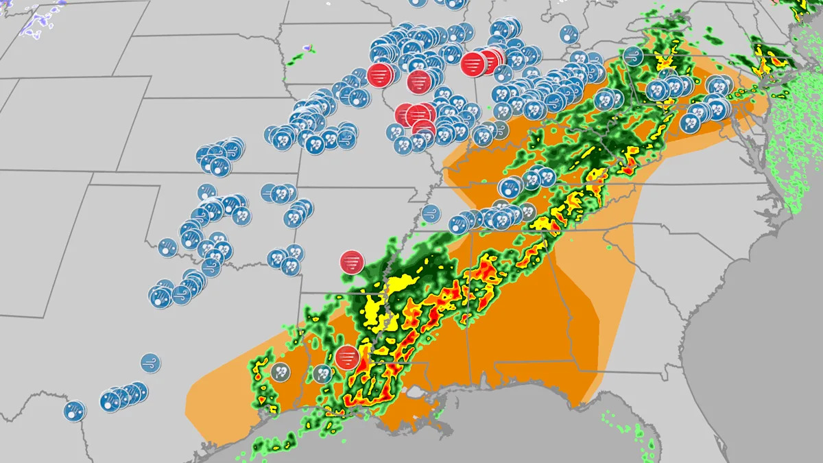
Wednesday was day two of severe weather stretching from the South to the Ohio Valley and mid-Atlantic states that already spawned multiple destructive tornadoes, giant hail and damaging winds in the Midwest and Plains Tuesday. This is happening less than a week after an outbreak of 24 tornadoes swarmed over many of the same areas.
(MORE: News As It Happened Wednesday)
What Happened Tuesday
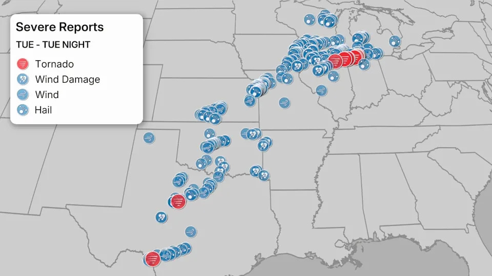
About 230 reports of severe weather were received by the National Weather Service Tuesday through early Wednesday morning, the most of any 24-hour period in the U.S. since July 28.
The most heavily damaged areas were from one supercell thunderstorm which tracked over 120 miles in almost 4.5 hours from northeast Illinois into northern Indiana. That supercell spawned destructive tornadoes in Kankakee, Illinois; Lake Village and Wheatfield, Indiana, according to the National Weather Service.
EF3 level damage consistant with winds of 150 mph was surveyed by NWS Chicago in the area of Aroma Park, Illinois. Further east, an EF1 tornado has been confirmed near Wheatfield, Indiana, with winds of around 110 mph.
(EXPERT ANALYSIS: The Setup For The Long Track Supercell)
This supercell also dumped giant hail from 5 to 6 inches in diameter in or near Buckingham, Campus and Kankakee, Illinois. This may have set a state hail record, something an ad hoc committee of meteorologists will examine at a later date.
A tornado emergency was issued for Knox, Indiana, last night. Survey teams will release information in the coming days.
A second supercell thunderstorm tracked into Chicagoland, dumping 3 to 5-inch diameter hail in the far southwest suburbs of Bolingbrook and Darien, then half-dollar size hail downtown at the Loop.
An EF1 tornado also moved through Moro and Midway, Illinois, early on March 11 with winds of 95 mph. There was one injury reported.
Elsewhere, hail up to baseball size pelted the western Oklahoma City metro area from a tornado-warned supercell thunderstorm. Several severe thunderstorms pelted the Kansas City metro with hail up to 2 inches in diameter.
At least two tornadoes touched down in western Texas, one just southeast of Abilene and the other just east of Laughlin Air Force Base near Del Rio.
There were also two EF1 tornadoes in southeastern Iowa near Donnellson in Lee County. One tornado had winds of 100 mph while the other had winds of 90 mph.
Flash flooding stranded vehicles in Grand Rapids and near Holland, Michigan.
(MORE: Latest News And Impacts)
Data: NOAA/NWS/SPC