
There have been no big changes to the forecast overnight. Everything remains on track for Minnesota’s major winter storm, with major impacts from Saturday evening through Sunday.
WCCO’s NEXT Weather Alert is in effect into Monday due to the effects of the storm, which will likely be the biggest of the season.
Its seriousness has prompted Minnesota Gov. Tim Walz to sign an executive order authorizing the Minnesota National Guard to support emergency operations until conditions caused by the storm subside.
A significant number of flights are cancelled at Minneapolis-St. Paul International Airport Saturday evening into Sunday, too, with airlines advising travelers to rebook their flights.
Twin Cities mayors to discuss storm preps
During a press conference on Saturday, both Mayors Kaohly Her and Jacob Frey announced snow emergencies. The emergencies will go into effect at 9 p.m. on Sunday, but residents of both cities are encouraged to move their cars on Saturday.
Minneapolis has opened up a parking lot at the Salvation Army and the parking lot at the farmers market. Parking at these locations will be free for residents until Wednesday at 8 p.m. Starting Sunday, Parking Ramp A in downtown Minneapolis will also be open and residents will only need to pay $1.
St. Paul will open up the block 19 ramp in downtown St. Paul, starting at 5 p.m. Saturday, for free parking for St. Paul residents. The city will also open some St. Paul park lots as they become available and recommend residents check the city’s website. St. Paul officials also said that due to the snow, there will be no garbage pickup Monday.

WCCO
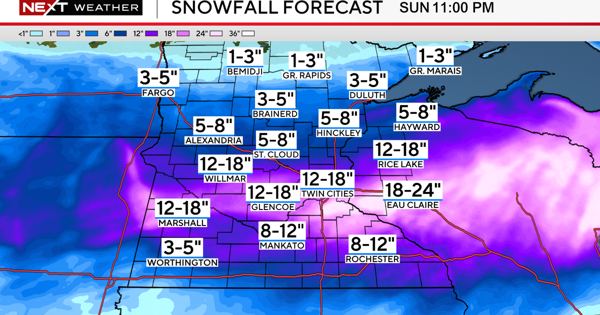
The state will be dry for most of the day Saturday, but snow picks up in coverage and intensity, mainly after 7 p.m., with the heaviest after midnight, with 1 to 3 inches per hour snowfall rates.
Twelve to 18 inches of snow is expected across the metro, with a few isolated spots in Wisconsin reaching over 18 inches.

WCCO
Closer to Interstate 90, some sleet and ice will mix in overnight, cutting back totals a bit, but the NEXT Weather team is still expecting travel area-wide to be very difficult, if not impossible, through Sunday afternoon with wind gusts 30 to 50 mph.
Most of the blizzard warnings are for Sunday morning and afternoon.
Snow wraps up into Sunday evening, but gusty winds continue into Monday with some lingering travel issues possible for the morning commute.
Continue to follow WCCO for extensive weather coverage.

WCCO
More from CBS News