
A Winter Storm Watch has been issued for SE Wisconsin ahead of a powerhouse storm.Milwaukee, Waukesha, Washington, Racine, Kenosha, Walworth, Jefferson, Dodge, Ozaukee, Sheboygan, and Fond du Lac counties are all in the Winter Storm Watch which ends Monday night.The storm will unfold in phases beginning Saturday night with a winter weather advisory in effect for our northern counties through Sunday morning for areas where 1 to 2 inches of snow could accumulate. A wintry mix will be possible for a time Saturday night into early Sunday, including a chance for sleet and freezing rain, particularly north of the I-94 corridor. Rain may also mix in for a time mainly along I-94. The wintry mix is expected transition to showers and isolated thunderstorms during the day on Sunday. Some storms could bring some breezy winds and small hail during the afternoon and early evening.The rain will switch back to moderate to heavy snow across southern Wisconsin Sunday evening once winds shift from the north on the back side of the storm, persisting into Monday. Snowfall totals of 3 to 6 inches are expected across most of the area, including Waukesha and Milwaukee, with lesser amounts in Racine and Kenosha. Higher totals between 6 to 9 inches are expected in areas of Dodge through Sheboygan counties. Strong winds and blowing snow will likely continue into Monday as well with winds gusting 40 to 45 mph, creating blowing and drifting snow. Northern parts of Fond du Lac county could see up to a foot of snow, with some areas of Wisconsin potentially receiving 2 feet from the single storm system.Shifts in the storm track are possible and that would make a big difference in snow totals.Extreme conditions are expected north of Green Bay toward Crivitz, where blizzard conditions will make travel dangerous.”These are extreme conditions. That means you do not want to drive in that at all,” Weather Watch 12’s Chief Meteorologist Mark Baden said.Monday morning’s commute is expected to be hazardous, with the possibility of school cancellations.High temperatures will drop into the 20s Monday and Tuesday before warming to near 50 degrees by the end of the week.
MILWAUKEE —
A Winter Storm Watch has been issued for SE Wisconsin ahead of a powerhouse storm.
Milwaukee, Waukesha, Washington, Racine, Kenosha, Walworth, Jefferson, Dodge, Ozaukee, Sheboygan, and Fond du Lac counties are all in the Winter Storm Watch which ends Monday night.
The storm will unfold in phases beginning Saturday night with a winter weather advisory in effect for our northern counties through Sunday morning for areas where 1 to 2 inches of snow could accumulate.
A wintry mix will be possible for a time Saturday night into early Sunday, including a chance for sleet and freezing rain, particularly north of the I-94 corridor. Rain may also mix in for a time mainly along I-94.
The wintry mix is expected transition to showers and isolated thunderstorms during the day on Sunday. Some storms could bring some breezy winds and small hail during the afternoon and early evening.
The rain will switch back to moderate to heavy snow across southern Wisconsin Sunday evening once winds shift from the north on the back side of the storm, persisting into Monday.
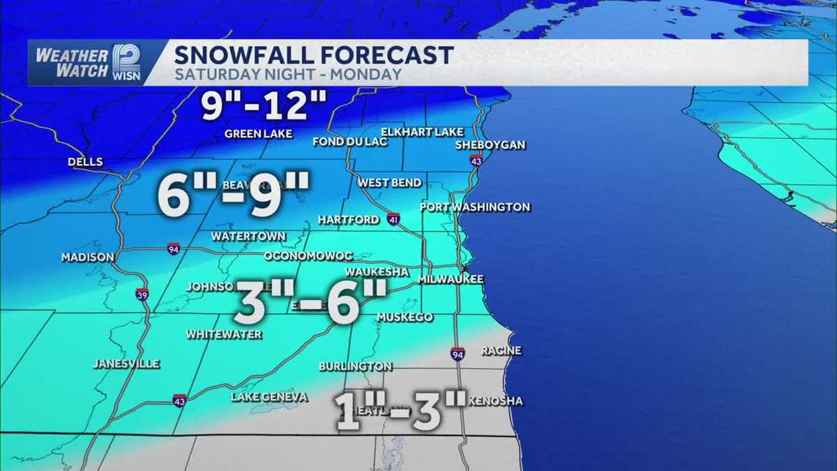
Snowfall totals of 3 to 6 inches are expected across most of the area, including Waukesha and Milwaukee, with lesser amounts in Racine and Kenosha. Higher totals between 6 to 9 inches are expected in areas of Dodge through Sheboygan counties.
Strong winds and blowing snow will likely continue into Monday as well with winds gusting 40 to 45 mph, creating blowing and drifting snow.
Northern parts of Fond du Lac county could see up to a foot of snow, with some areas of Wisconsin potentially receiving 2 feet from the single storm system.
Shifts in the storm track are possible and that would make a big difference in snow totals.
Extreme conditions are expected north of Green Bay toward Crivitz, where blizzard conditions will make travel dangerous.
“These are extreme conditions. That means you do not want to drive in that at all,” Weather Watch 12’s Chief Meteorologist Mark Baden said.
Monday morning’s commute is expected to be hazardous, with the possibility of school cancellations.
High temperatures will drop into the 20s Monday and Tuesday before warming to near 50 degrees by the end of the week.