A massive cloud extending up to 1,400km across Australia will see residents of two states cop a significant drenching this weekend. On Thursday, an incredible weather map highlighted the breadth of the northwest cloudband, which extends over western Queensland, northern South Australia, and the southern parts of the Northern Territory.
Meteorologists at Weatherzone have been tracking the cloud since it began above the Indian Ocean and predict it will combine with another system in the upper atmosphere on Friday. This will deliver heavy rain across parts of southern and eastern Queensland, as well as northern NSW.
“It will evolve into another system, becoming a trough,” meteorologist Yoska Hernandez told Yahoo News Australia.
Related: Warning to Aussies over destructive weather trend impacting cars and homes
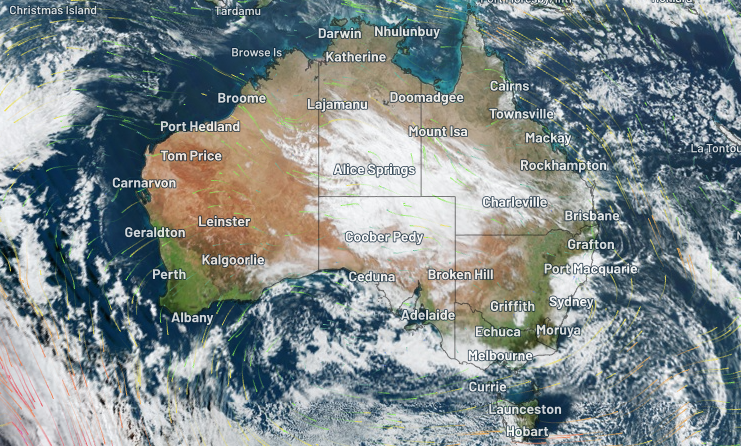
By Thursday the cloudband had begun to dissipate. Source: Weatherzone
Millions face a cold and rainy weekend
The cloudband is already beginning to dissipate, and on Saturday, the system will begin moving offshore. But rain will continue through Sunday, perhaps into Monday, across parts of NSW, including Sydney, due to another coastal trough.
Temperatures in Sydney will be two to three degrees below average in Sydney from Thursday through to Monday, which will be unwelcome news for millions of residents.
What causes these massive cloudbands?
Northwest cloudbands of this size are not uncommon from mid-autumn through to early Spring. They form when tropical moisture from the Indian Ocean passes over Australia. As the mass moves southeast, rising over cooler air, a large cloud is produced.
They tend to deliver significant rainfall when waters are warmer off Australia’s northwest coast, and right now their temperature is above average.
Love Australia’s weird and wonderful environment? 🐊🦘😳 Get our new newsletter showcasing the week’s best stories.