
An area of low barometric pressure is forecast to strengthen near the Bay Area on Sunday morning before weakening throughout the day. Its exact location will determine which areas experience the heaviest rain and strongest winds.
Baron/Lynx
San Francisco is facing its first rainy weekend since mid-February — and it could end up as the Bay Area’s wettest Friday-Sunday stretch in more than a year.
Saturday afternoon will be the most likely time for widespread rainfall. A cold front is forecast to bring a few hours of heavy rain, gusty winds and even a chance of thunder and lightning. A half-inch of rain could fall in one hour in parts of the region as the front swings through from west to east. Minor urban and small stream flooding is possible.
Article continues below this ad
Midday Friday will probably be the driest period of the next three days.
A band of rain is expected to push from southwest to northeast across the Bay Area on Friday morning, likely clearing out by noon. Isolated showers are possible the rest of the day, particularly in the afternoon in Wine Country, Santa Clara Valley and the interior East Bay valleys. Friday’s showers probably won’t drop more than a quarter of an inch of rain, though a few rumbles of thunder and dangerous cloud-to-ground lightning strikes are possible.
In the words of the National Weather Service, “if the rain on Friday leaves you unimpressed, wait until the weekend is over before putting your rain boots back in the attic.”
San Francisco Chronicle Logo
Make us a Preferred Source to get more of our news when you search.
Add Preferred Source
On Saturday morning, isolated to scattered showers will precede the afternoon cold front. Some of those showers will be strong and may even produce watersports or a brief tornado.
Article continues below this ad
A cold front moving across the Bay Area on Friday afternoon or early evening is forecast to drop a half-inch of rain in one hour in many places, enough to cause flooding on roadways and small streams and creeks.
Baron/Lynx
As the front blasts through, not only will rain increase, but winds will, too. Gusts of 25 to 40 mph are possible everywhere, and even stronger along the coast and in the hills. Thunderstorms could also be accompanied by higher wind speeds.
After the cold front has passed, the air mass will be chilly and unsettled behind it.
High temperatures are forecast to remain in the upper 50s in most places Sunday, which would be the Bay Area’s chilliest day since February. Nighttime temperatures will be in the low to mid-40s, with some cities falling to the upper 30s. The summits of Mount Hamilton and Mount Diablo may even get dusted with snow.
Rain won’t be as widespread after the cold front has gone past, but a low-pressure system in close proximity to the Bay Area will spin additional rain and hail showers over the entire region Saturday night to Sunday afternoon. The exact location of the low will influence which cities see the heaviest rain, with areas closest to its center picking up an inch of rain or more Sunday.
Article continues below this ad
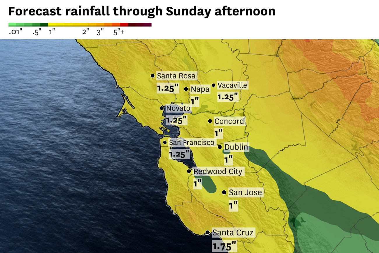
The National Weather Service forecasts 1 to 2 inches of rain across the Bay Area through Sunday, with up to 3 inches in the mountains. Rainfall totals may be highly variable due to the randomness of thunderstorm downpours.
Baron/Lynx
What once appeared to be a weak, quick-hitting weekend system has evolved into a full-blown storm forecast.
“It seems unlikely that this particular storm will be a dud,” the weather service said.
Friday through Sunday will probably be San Francisco’s wettest weekend since at least November 2024. The city hasn’t received more than an inch of rain in a weekend this wet season.
San Francisco averages 1.6 inches of rain in April, and this weekend’s forecast of 1 to 3 inches is likely to make it the city’s wettest April since 2018, when 3.9 inches of rain accumulated that month.
Article continues below this ad
Monday will mark the beginning of a warming and drying trend through midweek. It’s unclear how long the tranquil weather will last, with roughly equal odds of another rainmaker or of continued mild, sunny weather next weekend. Weather predictability is challenging beyond seven days in spring.
Weekend breakdown
San Francisco: Friday morning will probably start wet as light to moderate rain showers pass through. There’s even a chance of a rare lightning strike over the city that could wake residents up. Partial clearing is expected midday before more showers in the late afternoon and evening that’ll be accompanied by increasing breezes.
Saturday will begin with isolated to scattered showers before a cold front blasts through sometime in the afternoon or early evening. That’ll be the stormiest period of the weekend, with gusts up to 40 mph and potentially more claps of thunder. Highs Friday will be in the mid-60s, dropping to the low 60s Saturday. Lows will be in the upper 50s Friday night and low 50s Saturday night. Wet, breezy weather is forecast to continue Sunday, though it’s hard to predict exact rainfall amounts.
North Bay: Thunderstorms are possible Friday. A round of light to moderate rain showers in the morning may not be accompanied by much lightning and thunder, but another round in the afternoon will have more potential, especially in northern Napa County and eastern Solano County. Highs will be in the mid- to upper 60s with lows in the mid- to upper 50s.
Article continues below this ad
Showers will become more numerous as Saturday progresses, with increasing wind gusts up to 35 mph, stronger along the coast. A cold front will move through in the afternoon and bring an hour or two of heavy rain that could cause brief roadway, creek and stream flooding. A waterspout is possible along the coast. Highs will drop to the upper 50s to low 60s, making for the coolest day since mid-February, with lows in the low to mid-40s. Cool, wet and breezy weather will continue Sunday, though the forecast is still evolving regarding rain and wind details.
East Bay: The bubbly clouds of the past two days will tower even higher Friday as thunderstorm chances increase. The first band of showers will be in the morning, though those will probably be light to moderate. Another round in the afternoon is expected to be stronger, with the best chance of thunder and lightning east of the Caldecott Tunnel. That’ll be accompanied by increasing wind, too. Highs will be in the mid- to upper 60s with lows in the mid-50s.
Scattered showers will continue Saturday morning and will become more numerous as the day progresses. A cold front is predicted to move through in the late afternoon and bring downpours and strong wind. Gusts of up to 40 mph are possible, with rainfall rates of a half-inch per hour possibly causing nuisance flooding. Highs will drop to the low 60s, with lows crashing to the low to mid-40s. Sunday will be cool, wet and windy, though the specifics are hard to pin down. Temperatures will be similar to Saturday, if not a few degrees cooler.
Pacific Coast and Peninsula: Morning rain showers on Friday should taper for a few hours of midday sunshine before rain chances increase again in the afternoon. Thunder chances are lower along the Peninsula than elsewhere in the Bay Area, though an odd lightning bolt cannot be ruled out, especially around Redwood City and cities closer to the Santa Cruz Mountains. Highs will be in the low 60s at the coast and mid- to upper 60s along the Highway 101 corridor. Lows will be in the mid-50s.
Saturday will start showery and end showery, with a powerful afternoon cold front sandwiched in the middle. That cold front will bring a few hours of moderate to heavy rain with wind gusts up to 45 mph as it moves through. Beach conditions will be hazardous with big waves and even a chance of a waterspout or coastal tornado along the cold front. Highs will drop to the upper 50s to low 60s, with lows in the mid- to upper 40s. Showers will continue Sunday, possibly accompanied by hail and erratic wind gusts. Temperatures will be similar, if not slightly colder.
South Bay and Santa Cruz: Morning showers should clear out by 10 a.m. Friday for a few hours of sunshine. That solar energy will cause more bubbling clouds over the Diablo Range and Santa Cruz Mountains like in the past couple of days, except this time they’ll be more likely to drop rain and even a few lightning strikes. Highs will be in the mid- to upper 60s, with lows in the mid-50s.
Scattered showers Saturday morning will become more numerous as the day progresses. A cold front sweeping through in the late afternoon will bring a few hours of gusty winds of up to 40 mph and rainfall rates of a half-inch per hour or more. It could even spin up a waterspout or tornado in Santa Cruz County. After it passes, scattered showers will continue, with embedded small hail. Highs will be in the upper 50s to mid-60s, with lows in the 40s. Sunday will continue to be wet and windy, with temperatures about 5 degrees lower than Saturday.