
Tornadoes have damaged parts of northern Oklahoma as severe storms fired off Thursday afternoon. Damage has been reported around the Enid area as tornadoes tore through Thursday night. >> Go to the KOCO weather page | Get KOCO on the Go | Subscribe to KOCO 5’s YouTube channel | Sign up for KOCO 5’s Morning NewsletterBelow is a running blog of updates from Thursday’s storms WATCH: Homes flattened by violent tornado south of EnidWATCH: Large tornado spins up near Enid as storms track across Oklahoma10:37 p.m. Thursday Update:The tornado watch has expired for Oklahoma City, but a watch continues until 1 a.m. for Kingfisher, Logan, Payne, Garfield, Grant, Kay, Noble, Alfalfa and Major counties.10:35 p.m. Thursday Update:Garfield County Emergency Manager Jacob Price said so far, there have been around 11 people found with injuries, which were reportedly minor. No fatalities have been reported from Thursday night’s storms.Search and rescue operations are wrapping up in the Gray Ridge Estates area and crews are moving to the east side of State Highway 81.The Garfield County Pavilion at the fairgrounds will be opening as an emergency shelter.10:31 p.m. Thursday Update:The National Weather Service has issued a severe thunderstorm warning for west central Noble County and east central Garfield County.The main threats with the storms are golf ball sized hail and wind gusts up to 60 mph.Areas that could be impacted include Garber, Covington, and Fairmont.The warning is set to expire at 11:15 p.m.10:30 p.m. Thursday Update:Gov. Kevin Stitt released a statement on social media after learning of the tornado damage in Enid.“Please join me in praying for the Enid community, which has been severely impacted by tonight’s tornado.I have spoken with Enid’s local leaders and will continue working with them as they assess the damage and identify needs.My prayers are with everyone on Vance Air Force Base and the surrounding neighborhood, and I am asking God to bring healing and comfort in the days ahead.As storms continue to move across Oklahoma tonight, I urge everyone to stay weather aware, follow local warnings, and take shelter immediately when directed,” Stitt wrote in a social media post.10:25 p.m. Thursday Update:The National Weather Service has issued a severe thunderstorm warning for southern Noble County, northeastern Logan County, Payne County and southeastern Garfield County.The main threats with the storms are golf ball sized hail and 70 mph wind gusts.Areas that could be impacted include Stillwater, Perry, Perkins, Langston, Yale, Morrison, Glencoe, Ripley, Coyle, Mulhall, Orlando, Lake Carl Blackwell, Lake McMurtry, Lucien, Quay, Sooner Lake, and Ingalls.The warning is set to expire at 11:15 p.m.10:20 p.m. Thursday Update:Crews with the Enid Public Transportation are shuttling people from damaged areas to an overnight shelter Thursday night.The shuttles were headed to the hardest hit areas of the city and residents will be taken to Oakwood Christian Church, located at 401 N Oakwood Road.10:12 p.m. Thursday Update:The National Weather Service has issued a flash flood warning for east central Garfield County and west central Noble County until 1:15 a.m.Between 2 to 4 inches of rain have already fallen in the affected areas and an additional 1 to 2 inches of rain are expected.Locations that could be affected by flash flooding include Enid, Covington, Breckenridge, Fairmont, Lucien and Hayward.10:10 p.m. Thursday Update:The National Weather Service has issued a severe thunderstorm warning for central Garfield County. The main threats with the storms are 60 mph wind gusts and hail the size of quarters.Areas that could be impacted include Enid, Waukomis, Breckenridge, Fairmont, and Vance Air Force Base.The warning is set to expire at 10:45 p.m.9:55 p.m. Thursday Update:Enid Mayor David Mason said emergency crews are stationed in the city and heavy equipment is waiting to move in for clearing debris after tornadoes tore through the city Thursday night.Enid police and Oklahoma Highway Patrol troopers are going throughout the city.Mason said people had been rescued from the Gray Ridge area, among the hardest hit areas from Thursday night.Mason said that Vance Air Force Base suffered minor damage, including signage and fencing, but did not believe any homes were damaged. All personnel and planes were reportedly “fine.”He said the tornadoes barely missed the Enid-Woodring Airport as they tracked through the area.Mason said he’s been in touch with Gov. Kevin Stitt, who said he wanted an update on the storm damage. Stitt said he would send anything the city needed after the damage.A number of other state officials and lawmakers have reached out to talk with Mason after storms tracked through.9:50 p.m. Thursday Update:Mike Honigsberg, with the city of Enid, said that Gray Ridge on the south side of Enid has been leveled.He reported damage in other areas and search and rescue operations are underway.He said it may not be until Friday until they know the extent of the damage.Honigsberg said he was aware of injuries with the storms, but was unsure how many and how badly people were injured.9:35 p.m. Thursday Update:The National Weather Service has issued a severe thunderstorm warning for southern Noble County, northwestern Logan County, northwestern Payne County and southeastern Garfield County.The main threats with the storms are ping pong sized hail and wind gusts up to 60 mph.Areas that could be impacted include Stillwater, Perry, Morrison, Glencoe, Covington, Marshall, Orlando, Fairmont, Douglas, Lake Carl Blackwell, Lake McMurtry, Lucien, and Hayward.The warning is set to expire at 10:30 p.m.9:30 p.m. Thursday Update:Officials with the Enid Police Department reported a command center is being setup and that they are calling all officers in to respond after tornadoes ripped through the area Thursday night.Officials said Gray Ridge area, where there have been reports of people trapped in their homes and in their storm shelters.9:23 p.m. Thursday Update:The National Weather Service has issued a severe thunderstorm warning for southeastern Kay County until 10 p.m.The main threats with the storms are 60 mph wind gusts and half-dollar sized hail.Areas that could be impacted include Ponca City, Kaw City, and southwestern Kaw Lake.9:17 p.m. Thursday Update:The National Weather Service has issued a tornado warning southeastern Garfield County until 10 p.m.Areas that could be impacted include Covington, Douglas, and Hayward.Take shelter now.9 p.m. Thursday Update:The Garfield County Sheriff’s Office said deputies launched search and rescue operations for people trapped under debris after tornadoes touched down Thursday night.Officials said as far as they knew, everyone was OK and able to communicate, but they were trapped and emergency workers are in the early stages extracting them.Officials asked that people stay away from southeast Enid after as they are trying to get resources to the area.Resources are coming in from other counties, including Logan and Kingfisher counties.8:55 p.m. Thursday Update:A tornado warning remains in effect for central Garfield County until 9:30 p.m.Areas that could be impacted include Enid, Breckenridge and Fairmont.Those in the affected areas should take shelter now.8:45 p.m. Thursday Update:The National Weather Service has issued a tornado warning for central Garfield County until 9:30 p.m.Areas that could be impacted include Enid, Breckenridge, and Fairmont.Take shelter now.The National Weather Service has issued a severe thunderstorm warning for Kay County and southeastern Grant County.The main threats with storms are ping pong sized hail and 60 mph wind gusts.Areas that could be impacted include Ponca City, Blackwell, Tonkawa, Newkirk, Lamont, Kaw City, Kildare, Chilocco, Kaw Lake, Hardy, and Peckham.The warning is set to expire at 9:30 p.m.8:40 p.m. Thursday Update:A tornado warning remains in effect until 9 p.m. for east central Kay County.Areas that could be impacted include Kaw City and Kaw Lake.Take precautions now.8:25 p.m. Thursday Update: The National Weather Service has issued a tornado emergency for southeast Enid as a tornado warning remains in effect until 8:45 p.m.“You are in a life-threatening situation. Flying debris may be deadly to those caught without shelter. Mobile homes will be destroyed. Considerable damage to homes, businesses, and vehicles is likely and complete destruction is possible,” NWS officials said in the warning.Areas impacted include Enid, Waukomis, Breckenridge, Fairmont, and Vance Air Force Base.8:20 p.m. Thursday Update:Damon Lane and KOCO 5 Storm Chaser Amanda Benton report structures hit as large tornado moves near Vance Air Force Base Thursday.8:07 p.m. Thursday Update:The National Weather Service has issued a severe thunderstorm warning for Kay County and southeastern Grant County.The main threats with the storms are golf ball sized hail and wind gusts up to 60 mph.Areas that could be impacted include Ponca City, Blackwell, Tonkawa, Newkirk, Pond Creek, Lamont, Kaw City, Braman, Deer Creek, Kildare, Chilocco, Kaw Lake, Hardy, Nardin, and Peckham.The warning is set to expire at 8:45 p.m.8:02 p.m. Thursday Update:The National Weather Service has issued a tornado warning for central Garfield County until 8:45 p.m.Areas that could be impacted include Enid, Waukomis, Covington, Drummond, Breckenridge, Fairmont, Vance Air Force Base, and North Enid.Take shelter now.8 p.m. Thursday Update:Damon says U.S. 77 near Newkirk is closed. The Kay County Sheriff’s Office reported to Damon that there is some structural damage from tornadic storms that moved through the area earlier Thursday evening. 7:45 p.m. Thursday Update:The National Weather Service has issued a severe thunderstorm warning for central Garfield County.The main threats with the storms are ping pong sized hail and 60 mph wind gusts.Areas that could be impacted include Enid, Waukomis, Lahoma, Drummond, Kremlin, Breckenridge, Fairmont, Vance Air Force Base, and North Enid.The warning is set to expire at 8:30 p.m.7:40 p.m. Thursday Update:The National Weather Service has issued a tornado warning for northern Kay County until 8:30 p.m.Those in Newkirk and Peckham should take shelter immediatelyWATCH: Massive tornado spins up in far northern OklahomaWATCH: Tornadoes captured in far northern Oklahoma near BramanWATCH: Confirmed tornado touches down west of Braman7:35 p.m. Thursday Update:The National Weather Service has issued a severe thunderstorm warning for northwestern Kay County and eastern Grant County.The main threats with the storms are ping pong sized hail and 60 mph wind gusts.Areas that could be impacted include Blackwell, Pond Creek, Lamont, Braman, Deer Creek, Jefferson, Nardin, and Blackwell Lake.The warning is set to expire at 8:15 p.m.7:25 p.m. Thursday Update:A tornado warning remains in effect until 8 p.m. for northwestern Kay County.Tornadoes have been reported with an extremely dangerous tornado located near Braman.Those in Braman, Peckham and Blackwell Lake should take shelter now.The National Weather Service has issued a severe thunderstorm warning for eastern Grant County.The main threats with the storms are 60 mph wind gusts and hail the size of quarters.Areas that could be impacted include Medford, Deer Creek, Renfrow, and Jefferson.The warning is set to expire at 8 p.m.7:20 p.m. Thursday Update:Damon Lane reported lanes of Interstate 35 on the Oklahoma-Kansas border shut down as tornadic storms tracked through the area.7:10 p.m. Thursday Update:The National Weather Service has issued a tornado warning for northwestern Kay County until 8 p.m.Areas that could be impacted include Braman, Peckham and Blackwell Lake.People in the area should seek shelter now.6:45 p.m. Thursday Update:A tornado warning remains in effect until 7:15 p.m. for northwestern Kay and northeastern Grant counties.Areas that could be impacted include Newkirk, Braman, Chilocco, Blackwell Lake, and Peckham.Take precautions now.6:40 p.m. Thursday Update:The National Weather Service has issued a tornado warning for northwestern Kay County and northeastern Grant County until 7:15 p.m. Areas that could be impacted include Newkirk, Braman, Chilocco, Blackwell Lake, and Peckham.Those in the area of the storms should take shelter now.6:25 p.m. Thursday Update:The National Weather Service has issued a severe thunderstorm warning for northwestern Kay County and northeastern Grant County.The main threats with the storms are two-inch hail and 60 mph wind gusts.Areas that could be impacted include Newkirk, Braman, Renfrow, Blackwell Lake, and Peckham.The warning is set to expire at 7 p.m.5:45 p.m. Thursday Update:The National Weather Service has issued a severe thunderstorm warning for northwestern Kay County and northeastern Grant County.The main threats with the storms are ping pong sized hail and 60 mph wind gusts.Areas that could be impacted include Medford, Wakita, Renfrow, and Blackwell Lake.The warning is set to expire at 6:30 p.m.5:25 p.m. Thursday Update:Storms are beginning to fire off in western Oklahoma and along the Oklahoma-Kansas state line. The tornado index is highest from Oklahoma City to the north and northeast, it’s at a 4 out of 10, with other parts of the state at a 2 out of 10.5:20 p.m. Thursday Update:The National Weather Service has issued a tornado watch for Alfalfa, Blaine, Caddo, Canadian, Cleveland, Comanche, Garfield, Grady, Grant, Kay, Kingfisher, Logan, Major, McClain, Noble, Oklahoma, Osage, Pawnee, and Payne counties until 11 p.m.5 p.m. Thursday Update:KOCO 5 Chief Meteorologist Damon Lane said storms are trying to go up in western Oklahoma Thursday afternoon.He said if storms don’t fire off in the next few hours, the attention would be on later tonight as a cold front moves through, especially near Ponca City, Enid, Stillwater and Bartlesville.Oklahoma Storm Risk The level 3 enhanced risk has expanded to include more of north-central and northeastern Oklahoma. The risk zone, which initially clipped the state near Ponca City, now includes areas near Enid, Stillwater, Tulsa and Bartlesville. A level 2 slight risk also has been issued for central and southern Oklahoma. The OKC metro as well as Lawton, Ardmore, Ada, and Seminole are in the risk zone. There’s also a level 1 marginal risk in west-central and southeastern Oklahoma. Storms could produce tornadoes, 2-inch hail, and 60-70 mph winds. Oklahoma Tornado Risk We’re keeping an eye out for a few storms that will have a tornado potential on Thursday. The highest risk remains in far northern Oklahoma near Ponca City, which saw a tornado last Friday. The tornado index there is 6 out of 10. The risk for tornadoes is 4 out of 10 in areas north of OKC and Seminole. The risk zone includes Enid, Stillwater, Bartlesville, and parts of Tulsa. West-central to southern and northeastern Oklahoma has a tornado index of 2 out of 10. Oklahoma Hail Risk The biggest upgrade for the severe weather risk on Thursday is for hail. Areas in the level 3 enhanced risk zone could see hail stones the size of tennis balls and baseballs. Golf ball-sized hail and smaller are possible for much of the rest of the state, including the OKC metro. Severe Storm Timeline The dryline pushes in from 4-7 p.m. in west-central Oklahoma stretching to the OKC metro. Areas that could see storms during this window include areas east of Clinton, Hobart and Alva as well as in Lawton, El Reno, Yukon, OKC, Enid, and Ponca City. This risk is conditional. If a storm can break through the cap, we’d have a low chance of isolated severe storms. After that, we’ll keep an eye on northern Oklahoma as supercells could develop near Alva and Ponca City from 7-10 p.m. The storms will then move south and east near Enid, Stillwater, and Bartlesville by 10 p.m. to 1 a.m. Friday. There’s a higher chance that storms build into a line and clip Oklahoma City around midnight through 4 a.m. Friday. Friday Storm RiskThere’s another severe weather threat on Friday, as there’s a level 2 slight risk in southeastern Oklahoma. There’s also a level 1 marginal risk from Lawton to Ardmore, the OKC metro, Stillwater, Tulsa, and eastern Oklahoma. Friday Tornado Risk The risk remains low on Friday, as the tornado index sits at a 2 out of 10 for southern, eastern and parts of central Oklahoma. The OKC metro is on the fringe of that risk zone. Saturday Storm Risk The severe weather threat really ramps up on Saturday, as there’s already a level 3 enhanced risk for part of Oklahoma. The level risk zone includes Alva, Seminole, Enid, Stillwater, Ponca City, Bartlesville, and Tulsa. The OKC metro is on the border of the level 3 enhanced risk and the level 2 slight risk zones. The level 2 zone also includes areas near Woodward to Norman, north of Ardmore, and to southeastern Oklahoma. There’s also a level 1 marginal risk in western and southwestern Oklahoma. KOCO 5 First Alert Weather Team, led by Chief Meteorologist Damon Lane, has been certified by WeatheRate as providing the Most Accurate Forecast in Oklahoma City for 14 consecutive years. This outstanding achievement underscores KOCO 5’s unwavering dedication to delivering reliable weather forecasts to viewers.
Tornadoes have damaged parts of northern Oklahoma as severe storms fired off Thursday afternoon. Damage has been reported around the Enid area as tornadoes tore through Thursday night.
>> Go to the KOCO weather page | Get KOCO on the Go | Subscribe to KOCO 5’s YouTube channel | Sign up for KOCO 5’s Morning Newsletter
Below is a running blog of updates from Thursday’s storms
WATCH: Homes flattened by violent tornado south of Enid
WATCH: Large tornado spins up near Enid as storms track across Oklahoma
10:37 p.m. Thursday Update:
The tornado watch has expired for Oklahoma City, but a watch continues until 1 a.m. for Kingfisher, Logan, Payne, Garfield, Grant, Kay, Noble, Alfalfa and Major counties.
10:35 p.m. Thursday Update:
Garfield County Emergency Manager Jacob Price said so far, there have been around 11 people found with injuries, which were reportedly minor. No fatalities have been reported from Thursday night’s storms.
Search and rescue operations are wrapping up in the Gray Ridge Estates area and crews are moving to the east side of State Highway 81.
The Garfield County Pavilion at the fairgrounds will be opening as an emergency shelter.
10:31 p.m. Thursday Update:
The National Weather Service has issued a severe thunderstorm warning for west central Noble County and east central Garfield County.
The main threats with the storms are golf ball sized hail and wind gusts up to 60 mph.
Areas that could be impacted include Garber, Covington, and Fairmont.
The warning is set to expire at 11:15 p.m.
10:30 p.m. Thursday Update:
Gov. Kevin Stitt released a statement on social media after learning of the tornado damage in Enid.
“Please join me in praying for the Enid community, which has been severely impacted by tonight’s tornado.
I have spoken with Enid’s local leaders and will continue working with them as they assess the damage and identify needs.
My prayers are with everyone on Vance Air Force Base and the surrounding neighborhood, and I am asking God to bring healing and comfort in the days ahead.
As storms continue to move across Oklahoma tonight, I urge everyone to stay weather aware, follow local warnings, and take shelter immediately when directed,” Stitt wrote in a social media post.
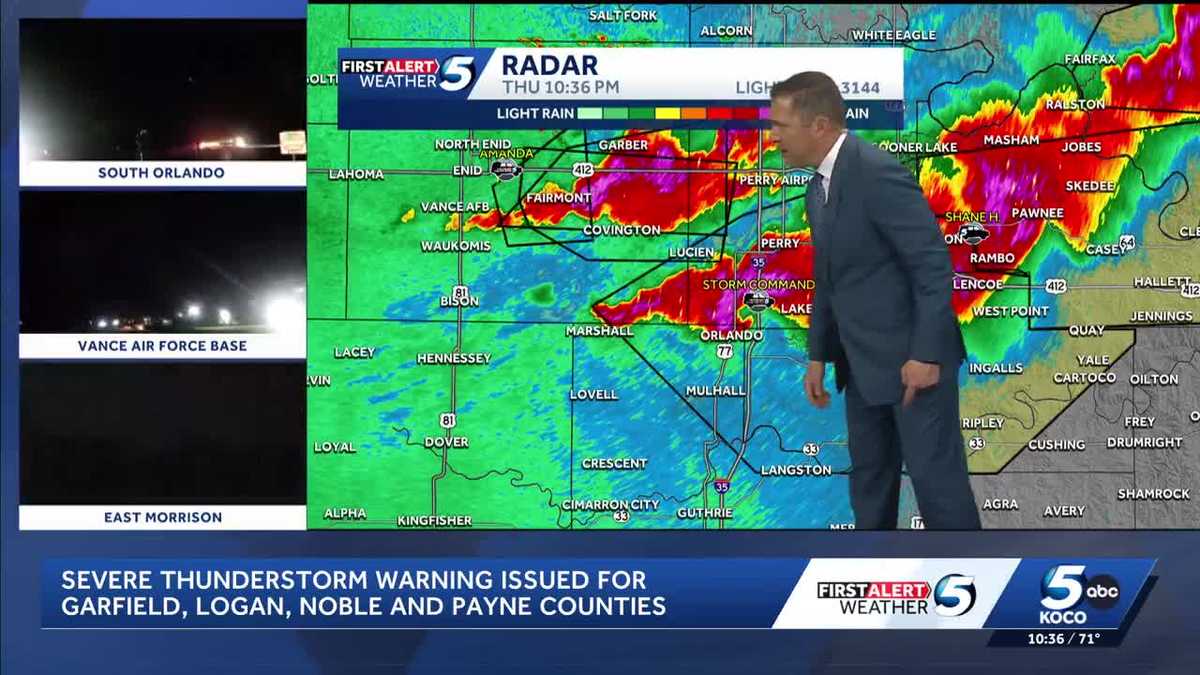
10:25 p.m. Thursday Update:
The National Weather Service has issued a severe thunderstorm warning for southern Noble County, northeastern Logan County, Payne County and southeastern Garfield County.
The main threats with the storms are golf ball sized hail and 70 mph wind gusts.
Areas that could be impacted include Stillwater, Perry, Perkins, Langston, Yale, Morrison, Glencoe, Ripley, Coyle, Mulhall, Orlando, Lake Carl Blackwell, Lake McMurtry, Lucien, Quay, Sooner Lake, and Ingalls.
The warning is set to expire at 11:15 p.m.
10:20 p.m. Thursday Update:
Crews with the Enid Public Transportation are shuttling people from damaged areas to an overnight shelter Thursday night.
The shuttles were headed to the hardest hit areas of the city and residents will be taken to Oakwood Christian Church, located at 401 N Oakwood Road.
10:12 p.m. Thursday Update:
The National Weather Service has issued a flash flood warning for east central Garfield County and west central Noble County until 1:15 a.m.
Between 2 to 4 inches of rain have already fallen in the affected areas and an additional 1 to 2 inches of rain are expected.
Locations that could be affected by flash flooding include Enid, Covington, Breckenridge, Fairmont, Lucien and Hayward.
10:10 p.m. Thursday Update:
The National Weather Service has issued a severe thunderstorm warning for central Garfield County.
The main threats with the storms are 60 mph wind gusts and hail the size of quarters.
Areas that could be impacted include Enid, Waukomis, Breckenridge, Fairmont, and Vance Air Force Base.
The warning is set to expire at 10:45 p.m.
9:55 p.m. Thursday Update:
Enid Mayor David Mason said emergency crews are stationed in the city and heavy equipment is waiting to move in for clearing debris after tornadoes tore through the city Thursday night.
Enid police and Oklahoma Highway Patrol troopers are going throughout the city.
Mason said people had been rescued from the Gray Ridge area, among the hardest hit areas from Thursday night.
Mason said that Vance Air Force Base suffered minor damage, including signage and fencing, but did not believe any homes were damaged. All personnel and planes were reportedly “fine.”
He said the tornadoes barely missed the Enid-Woodring Airport as they tracked through the area.
Mason said he’s been in touch with Gov. Kevin Stitt, who said he wanted an update on the storm damage. Stitt said he would send anything the city needed after the damage.
A number of other state officials and lawmakers have reached out to talk with Mason after storms tracked through.
9:50 p.m. Thursday Update:
Mike Honigsberg, with the city of Enid, said that Gray Ridge on the south side of Enid has been leveled.
He reported damage in other areas and search and rescue operations are underway.
He said it may not be until Friday until they know the extent of the damage.
Honigsberg said he was aware of injuries with the storms, but was unsure how many and how badly people were injured.
9:35 p.m. Thursday Update:
The National Weather Service has issued a severe thunderstorm warning for southern Noble County, northwestern Logan County, northwestern Payne County and southeastern Garfield County.
The main threats with the storms are ping pong sized hail and wind gusts up to 60 mph.
Areas that could be impacted include Stillwater, Perry, Morrison, Glencoe, Covington, Marshall, Orlando, Fairmont, Douglas, Lake Carl Blackwell, Lake McMurtry, Lucien, and Hayward.
The warning is set to expire at 10:30 p.m.
9:30 p.m. Thursday Update:
Officials with the Enid Police Department reported a command center is being setup and that they are calling all officers in to respond after tornadoes ripped through the area Thursday night.
Officials said Gray Ridge area, where there have been reports of people trapped in their homes and in their storm shelters.
9:23 p.m. Thursday Update:
The National Weather Service has issued a severe thunderstorm warning for southeastern Kay County until 10 p.m.
The main threats with the storms are 60 mph wind gusts and half-dollar sized hail.
Areas that could be impacted include Ponca City, Kaw City, and southwestern Kaw Lake.
9:17 p.m. Thursday Update:
The National Weather Service has issued a tornado warning southeastern Garfield County until 10 p.m.
Areas that could be impacted include Covington, Douglas, and Hayward.
Take shelter now.
9 p.m. Thursday Update:
The Garfield County Sheriff’s Office said deputies launched search and rescue operations for people trapped under debris after tornadoes touched down Thursday night.
Officials said as far as they knew, everyone was OK and able to communicate, but they were trapped and emergency workers are in the early stages extracting them.
Officials asked that people stay away from southeast Enid after as they are trying to get resources to the area.
Resources are coming in from other counties, including Logan and Kingfisher counties.
8:55 p.m. Thursday Update:
A tornado warning remains in effect for central Garfield County until 9:30 p.m.
Areas that could be impacted include Enid, Breckenridge and Fairmont.
Those in the affected areas should take shelter now.
8:45 p.m. Thursday Update:
The National Weather Service has issued a tornado warning for central Garfield County until 9:30 p.m.
Areas that could be impacted include Enid, Breckenridge, and Fairmont.
Take shelter now.
The National Weather Service has issued a severe thunderstorm warning for Kay County and southeastern Grant County.
The main threats with storms are ping pong sized hail and 60 mph wind gusts.
Areas that could be impacted include Ponca City, Blackwell, Tonkawa, Newkirk, Lamont, Kaw City, Kildare, Chilocco, Kaw Lake, Hardy, and Peckham.
The warning is set to expire at 9:30 p.m.
8:40 p.m. Thursday Update:
A tornado warning remains in effect until 9 p.m. for east central Kay County.
Areas that could be impacted include Kaw City and Kaw Lake.
Take precautions now.
8:25 p.m. Thursday Update:
The National Weather Service has issued a tornado emergency for southeast Enid as a tornado warning remains in effect until 8:45 p.m.
“You are in a life-threatening situation. Flying debris may be deadly to those caught without shelter. Mobile homes will be destroyed. Considerable damage to homes, businesses, and vehicles is likely and complete destruction is possible,” NWS officials said in the warning.
Areas impacted include Enid, Waukomis, Breckenridge, Fairmont, and Vance Air Force Base.
8:20 p.m. Thursday Update:
Damon Lane and KOCO 5 Storm Chaser Amanda Benton report structures hit as large tornado moves near Vance Air Force Base Thursday.
8:07 p.m. Thursday Update:
The National Weather Service has issued a severe thunderstorm warning for Kay County and southeastern Grant County.
The main threats with the storms are golf ball sized hail and wind gusts up to 60 mph.
Areas that could be impacted include Ponca City, Blackwell, Tonkawa, Newkirk, Pond Creek, Lamont, Kaw City, Braman, Deer Creek, Kildare, Chilocco, Kaw Lake, Hardy, Nardin, and Peckham.
The warning is set to expire at 8:45 p.m.
8:02 p.m. Thursday Update:
The National Weather Service has issued a tornado warning for central Garfield County until 8:45 p.m.
Areas that could be impacted include Enid, Waukomis, Covington, Drummond, Breckenridge, Fairmont, Vance Air Force Base, and North Enid.
Take shelter now.
8 p.m. Thursday Update:
Damon says U.S. 77 near Newkirk is closed.
The Kay County Sheriff’s Office reported to Damon that there is some structural damage from tornadic storms that moved through the area earlier Thursday evening.
7:45 p.m. Thursday Update:
The National Weather Service has issued a severe thunderstorm warning for central Garfield County.
The main threats with the storms are ping pong sized hail and 60 mph wind gusts.
Areas that could be impacted include Enid, Waukomis, Lahoma, Drummond, Kremlin, Breckenridge, Fairmont, Vance Air Force Base, and North Enid.
The warning is set to expire at 8:30 p.m.
7:40 p.m. Thursday Update:
The National Weather Service has issued a tornado warning for northern Kay County until 8:30 p.m.
Those in Newkirk and Peckham should take shelter immediately
WATCH: Massive tornado spins up in far northern Oklahoma
WATCH: Tornadoes captured in far northern Oklahoma near Braman
WATCH: Confirmed tornado touches down west of Braman
7:35 p.m. Thursday Update:
The National Weather Service has issued a severe thunderstorm warning for northwestern Kay County and eastern Grant County.
The main threats with the storms are ping pong sized hail and 60 mph wind gusts.
Areas that could be impacted include Blackwell, Pond Creek, Lamont, Braman, Deer Creek, Jefferson, Nardin, and Blackwell Lake.
The warning is set to expire at 8:15 p.m.
7:25 p.m. Thursday Update:
A tornado warning remains in effect until 8 p.m. for northwestern Kay County.
Tornadoes have been reported with an extremely dangerous tornado located near Braman.
Those in Braman, Peckham and Blackwell Lake should take shelter now.
The National Weather Service has issued a severe thunderstorm warning for eastern Grant County.
The main threats with the storms are 60 mph wind gusts and hail the size of quarters.
Areas that could be impacted include Medford, Deer Creek, Renfrow, and Jefferson.
The warning is set to expire at 8 p.m.
7:20 p.m. Thursday Update:
Damon Lane reported lanes of Interstate 35 on the Oklahoma-Kansas border shut down as tornadic storms tracked through the area.
7:10 p.m. Thursday Update:
The National Weather Service has issued a tornado warning for northwestern Kay County until 8 p.m.
Areas that could be impacted include Braman, Peckham and Blackwell Lake.
People in the area should seek shelter now.
6:45 p.m. Thursday Update:
A tornado warning remains in effect until 7:15 p.m. for northwestern Kay and northeastern Grant counties.
Areas that could be impacted include Newkirk, Braman, Chilocco, Blackwell Lake, and Peckham.
Take precautions now.
6:40 p.m. Thursday Update:
The National Weather Service has issued a tornado warning for northwestern Kay County and northeastern Grant County until 7:15 p.m.
Areas that could be impacted include Newkirk, Braman, Chilocco, Blackwell Lake, and Peckham.
Those in the area of the storms should take shelter now.
6:25 p.m. Thursday Update:
The National Weather Service has issued a severe thunderstorm warning for northwestern Kay County and northeastern Grant County.
The main threats with the storms are two-inch hail and 60 mph wind gusts.
Areas that could be impacted include Newkirk, Braman, Renfrow, Blackwell Lake, and Peckham.
The warning is set to expire at 7 p.m.
5:45 p.m. Thursday Update:
The National Weather Service has issued a severe thunderstorm warning for northwestern Kay County and northeastern Grant County.
The main threats with the storms are ping pong sized hail and 60 mph wind gusts.
Areas that could be impacted include Medford, Wakita, Renfrow, and Blackwell Lake.
The warning is set to expire at 6:30 p.m.
5:25 p.m. Thursday Update:
Storms are beginning to fire off in western Oklahoma and along the Oklahoma-Kansas state line.
The tornado index is highest from Oklahoma City to the north and northeast, it’s at a 4 out of 10, with other parts of the state at a 2 out of 10.

5:20 p.m. Thursday Update:
The National Weather Service has issued a tornado watch for Alfalfa, Blaine, Caddo, Canadian, Cleveland, Comanche, Garfield, Grady, Grant, Kay, Kingfisher, Logan, Major, McClain, Noble, Oklahoma, Osage, Pawnee, and Payne counties until 11 p.m.
5 p.m. Thursday Update:
KOCO 5 Chief Meteorologist Damon Lane said storms are trying to go up in western Oklahoma Thursday afternoon.
He said if storms don’t fire off in the next few hours, the attention would be on later tonight as a cold front moves through, especially near Ponca City, Enid, Stillwater and Bartlesville.


Oklahoma Storm Risk
The level 3 enhanced risk has expanded to include more of north-central and northeastern Oklahoma. The risk zone, which initially clipped the state near Ponca City, now includes areas near Enid, Stillwater, Tulsa and Bartlesville.
A level 2 slight risk also has been issued for central and southern Oklahoma. The OKC metro as well as Lawton, Ardmore, Ada, and Seminole are in the risk zone.
There’s also a level 1 marginal risk in west-central and southeastern Oklahoma.

Storms could produce tornadoes, 2-inch hail, and 60-70 mph winds.
Oklahoma Tornado Risk
We’re keeping an eye out for a few storms that will have a tornado potential on Thursday.
The highest risk remains in far northern Oklahoma near Ponca City, which saw a tornado last Friday. The tornado index there is 6 out of 10.
The risk for tornadoes is 4 out of 10 in areas north of OKC and Seminole. The risk zone includes Enid, Stillwater, Bartlesville, and parts of Tulsa.
West-central to southern and northeastern Oklahoma has a tornado index of 2 out of 10.

Oklahoma Hail Risk
The biggest upgrade for the severe weather risk on Thursday is for hail. Areas in the level 3 enhanced risk zone could see hail stones the size of tennis balls and baseballs.
Golf ball-sized hail and smaller are possible for much of the rest of the state, including the OKC metro.

Severe Storm Timeline
The dryline pushes in from 4-7 p.m. in west-central Oklahoma stretching to the OKC metro. Areas that could see storms during this window include areas east of Clinton, Hobart and Alva as well as in Lawton, El Reno, Yukon, OKC, Enid, and Ponca City.
This risk is conditional. If a storm can break through the cap, we’d have a low chance of isolated severe storms.

After that, we’ll keep an eye on northern Oklahoma as supercells could develop near Alva and Ponca City from 7-10 p.m. The storms will then move south and east near Enid, Stillwater, and Bartlesville by 10 p.m. to 1 a.m. Friday.
There’s a higher chance that storms build into a line and clip Oklahoma City around midnight through 4 a.m. Friday.

Friday Storm Risk
There’s another severe weather threat on Friday, as there’s a level 2 slight risk in southeastern Oklahoma. There’s also a level 1 marginal risk from Lawton to Ardmore, the OKC metro, Stillwater, Tulsa, and eastern Oklahoma.

Friday Tornado Risk
The risk remains low on Friday, as the tornado index sits at a 2 out of 10 for southern, eastern and parts of central Oklahoma. The OKC metro is on the fringe of that risk zone.

Saturday Storm Risk
The severe weather threat really ramps up on Saturday, as there’s already a level 3 enhanced risk for part of Oklahoma. The level risk zone includes Alva, Seminole, Enid, Stillwater, Ponca City, Bartlesville, and Tulsa.
The OKC metro is on the border of the level 3 enhanced risk and the level 2 slight risk zones. The level 2 zone also includes areas near Woodward to Norman, north of Ardmore, and to southeastern Oklahoma.
There’s also a level 1 marginal risk in western and southwestern Oklahoma.

KOCO 5 First Alert Weather Team, led by Chief Meteorologist Damon Lane, has been certified by WeatheRate as providing the Most Accurate Forecast in Oklahoma City for 14 consecutive years. This outstanding achievement underscores KOCO 5’s unwavering dedication to delivering reliable weather forecasts to viewers.