
Storms prompted numerous tornado warnings to be issued on Saturday in southern Oklahoma, and the severe weather threat continues on Sunday. >> Go to the KOCO weather page | Get KOCO on the Go | Subscribe to KOCO 5’s YouTube channel | Sign up for KOCO 5’s Morning NewsletterBelow was a running blog from Saturday’s storms. Our coverage has ended for the evening. Scroll down to learn mor about the weather event. 8:40 p.m. Saturday Update: Severe Thunderstorm Warning Tornado warnings have been dropped, but a severe thunderstorm warning continues for Garvin County until 9:15 p.m. 8:25 p.m. Saturday Update: Tornado Warning Update A tornado warning remains in effect for central Johnston County until 8:45 p.m. A severe thunderstorm is capable of producing a tornado was spotted near Mill Creek moving east at 15 mph. 8:22 p.m. Saturday Update: Tornado Warning Update A tornado warning that was issued for southwestern Garvin County in southern Oklahoma has been dropped. 8:13 p.m. Saturday Update: Tornado Warning A tornado warning has been issued for southwestern Garvin County in southern Oklahoma until 8:45 p.m. The National Weather Service says a severe thunderstorm capable of producing a tornado was located 4 miles southeast of Foster. That storm is moving 25 mph and could produce golf ball-sized hail. 8:11 p.m. Saturday Update: Tornado Warning A tornado warning has been issued for east-central Garvin County, southwestern Pontotoc County, and northeastern Murray County until 9 p.m. 8:07 p.m. Saturday Update: Tornado Warning Update A tornado warning remains in effect until 8:30 p.m. for north-central Johnston County and south-central Pontotoc County. The National Weather Service says half dollar-sized hail is possible with these storms, which are moving southeast at 15 mph. 7:56 p.m. Saturday Update: Tornado WarningA tornado warning has been issued for Johnston, Carter, and Murray counties until 8:45 p.m. The National Weather Service says a severe thunderstorm is capable of producing a tornado was located 6 miles southwest of Mill Creek. That storm is moving southeast at 20 mph. 7:52 p.m. Saturday Update: Tornado Warning A tornado warning has been issued for Johnston County in southeastern Oklahoma until 8:30 p.m. The National Weather Service says there’s severe thunderstorm in the area capable of producing a tornado. 7:47 p.m. Saturday Update: Radar-Confirmed Tornado Damon says radar confirms that there was a tornado southeast of Pauls Valley and northeast of Wynnewood. Radar has not confirmed any debris. 7:39 p.m. Saturday Updates: Tornado Warning A tornado warning has been issued for north-central Johnston County, southeastern Pontotoc County, and east-central Murray County until 8:30 p.m. 7:30 p.m. Saturday Updates: Tornado Developing and Tornado WarningA tornado is developing near the town of Roff, and a tornado warning has been issued for Garvin and Murray counties until 8:15 p.m. Video Below: Developing tornado caught on camera near Roff7:22 p.m. Saturday Update: Severe Thunderstorm Warning A severe thunderstorm warning has been issued for Coal County, southeastern Pontotoc County, and north-central Atoka County until 8 p.m. 7:10 p.m. Saturday Update: Severe Thunderstorm Warning A severe thunderstorm warning remains in effect until 7:30 p.m. for western Garvin, Southeastern Grady, northeastern Stephens, and southwestern McClain counites. 7:07 p.m. Saturday Update: Tornado Warning IssuedA tornado warning has been issued for north-central Johnston County, east-central Garvin County, southwestern Pontotoc County, and northeastern Murray County until 7:45 p.m. 6:30 p.m. Saturday Update The tornado warnings issued for Pontotoc and Seminole counties have expired. 6:22 p.m. Saturday Update: Tornado Warning Update Damon says the tornado warning in Pontotoc County will be allowed to expire at 6:30 p.m. 6:15 p.m. Saturday Update: Severe Thunderstorm Warning A severe thunderstorm warning has been issued for west-central Coal County, south-central Seminole County, northeastern Pontotoc County, and southwestern Hughes County until 7 p.m. The National Weather Service says the storms could produce 60 mph wind gusts and half dollar-sized hail. 5:50 p.m. Saturday Update: Tornado WarningA tornado warning has been issued for Seminole and Pontotoc counties until 6:30 p.m. Saturday. 5:30 p.m. Saturday Update: Severe Thunderstorm Warning IssuedThe National Weather Service has issued a severe thunderstorm warning for northeastern Garvin County, southwestern Seminole County, central Pontotoc County and southeastern McClain County.The main threats with the storms are 60 mph wind gusts and half dollar sized hail.Areas that could be impacted include Ada, Stratford, Byng, Francis, Byars, and Vanoss.The warning is set to expire at 6:15 p.m.3:55 p.m. Saturday Update: Tornado Watch IssuedThe National Weather Service has issued a tornado watch for Atoka, Bryan, Caddo, Canadian, Carter, Choctaw, Cleveland, Coal, Comanche, Cotton, Creek, Garvin, Grady, Haskell, Hughes, Jefferson, Johnston, Latimer, LeFlore, Lincoln, Love, Marshall, McClain, McCurtain, McIntosh, Murray, Okfuskee, Oklahoma, Okmulgee, Pittsburg, Pontotoc, Pottawatomie, Pushmataha, Seminole and Stephens counties until 11 p.m. 2:45 p.m. Saturday Update: Thunderstorm Watch IssuedThe National Weather Service has issued a severe thunderstorm watch for Alfalfa, Blaine, Custer, Dewey, Garfield, Grant, Harper, Kay, Kingfisher, Logan, Major, Noble, Payne, Woods and Woodward counties until 9 p.m.Storms could produce tornadoes and large, damaging hail. KOCO 5 Meteorologist Mikayla Smith shows what you need to know. Saturday Storm Risk The level 4 moderate risk has been issued for southeastern Oklahoma near Seminole, Ada, and McAlester. Surrounding areas ranging from Durant to Ardmore, OKC, Ponca City, Bartlesville, and Stillwater have a level 3 enhanced risk. West-central to northern and northeastern Oklahoma have a level 2 slight risk, and western Oklahoma has a level 1 marginal risk. Oklahoma Tornado Risk The upgrade in the severe storm risk also comes with an increase in the tornado index. Southeastern Oklahoma, south-central Oklahoma, and the OKC metro have a tornado index of 6 out of 10. The tornado index decreases to a 4 and 2 in central, west-central, and northern Oklahoma. Oklahoma Hail Risk Storms on Saturday also could produce baseball-sized hail. The biggest threat for large, damaging hail is in southeastern Oklahoma near Ardmore, Ada, Seminole, Durant, and McAlester. Central to eastern Oklahoma, including the OKC metro, could see tennis ball-sized hail. Smaller hail is possible in the rest of the state. Severe Storm Timeline Storms are expected to fire up in the OKC metro, Lawton, Stillwater, Ponca City, and Bartlesville from 4-6 p.m. Saturday and continue east by 6-8 p.m. They are expected to be in southeastern Oklahoma after 8 p.m. KOCO 5 First Alert Weather Team, led by Chief Meteorologist Damon Lane, has been certified by WeatheRate as providing the Most Accurate Forecast in Oklahoma City for 14 consecutive years. This outstanding achievement underscores KOCO 5’s unwavering dedication to delivering reliable weather forecasts to viewers.
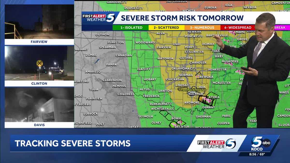
Storms prompted numerous tornado warnings to be issued on Saturday in southern Oklahoma, and the severe weather threat continues on Sunday.
>> Go to the KOCO weather page | Get KOCO on the Go | Subscribe to KOCO 5’s YouTube channel | Sign up for KOCO 5’s Morning Newsletter
Below was a running blog from Saturday’s storms. Our coverage has ended for the evening. Scroll down to learn mor about the weather event.
8:40 p.m. Saturday Update: Severe Thunderstorm Warning
Tornado warnings have been dropped, but a severe thunderstorm warning continues for Garvin County until 9:15 p.m.
8:25 p.m. Saturday Update: Tornado Warning Update
A tornado warning remains in effect for central Johnston County until 8:45 p.m. A severe thunderstorm is capable of producing a tornado was spotted near Mill Creek moving east at 15 mph.
8:22 p.m. Saturday Update: Tornado Warning Update
A tornado warning that was issued for southwestern Garvin County in southern Oklahoma has been dropped.
8:13 p.m. Saturday Update: Tornado Warning
A tornado warning has been issued for southwestern Garvin County in southern Oklahoma until 8:45 p.m.
The National Weather Service says a severe thunderstorm capable of producing a tornado was located 4 miles southeast of Foster. That storm is moving 25 mph and could produce golf ball-sized hail.
8:11 p.m. Saturday Update: Tornado Warning
A tornado warning has been issued for east-central Garvin County, southwestern Pontotoc County, and northeastern Murray County until 9 p.m.
8:07 p.m. Saturday Update: Tornado Warning Update
A tornado warning remains in effect until 8:30 p.m. for north-central Johnston County and south-central Pontotoc County. The National Weather Service says half dollar-sized hail is possible with these storms, which are moving southeast at 15 mph.
7:56 p.m. Saturday Update: Tornado Warning
A tornado warning has been issued for Johnston, Carter, and Murray counties until 8:45 p.m.
The National Weather Service says a severe thunderstorm is capable of producing a tornado was located 6 miles southwest of Mill Creek. That storm is moving southeast at 20 mph.
7:52 p.m. Saturday Update: Tornado Warning
A tornado warning has been issued for Johnston County in southeastern Oklahoma until 8:30 p.m. The National Weather Service says there’s severe thunderstorm in the area capable of producing a tornado.
7:47 p.m. Saturday Update: Radar-Confirmed Tornado
Damon says radar confirms that there was a tornado southeast of Pauls Valley and northeast of Wynnewood. Radar has not confirmed any debris.
7:39 p.m. Saturday Updates: Tornado Warning
A tornado warning has been issued for north-central Johnston County, southeastern Pontotoc County, and east-central Murray County until 8:30 p.m.
7:30 p.m. Saturday Updates: Tornado Developing and Tornado Warning
A tornado is developing near the town of Roff, and a tornado warning has been issued for Garvin and Murray counties until 8:15 p.m.
Video Below: Developing tornado caught on camera near Roff
7:22 p.m. Saturday Update: Severe Thunderstorm Warning
A severe thunderstorm warning has been issued for Coal County, southeastern Pontotoc County, and north-central Atoka County until 8 p.m.
7:10 p.m. Saturday Update: Severe Thunderstorm Warning
A severe thunderstorm warning remains in effect until 7:30 p.m. for western Garvin, Southeastern Grady, northeastern Stephens, and southwestern McClain counites.
7:07 p.m. Saturday Update: Tornado Warning Issued
A tornado warning has been issued for north-central Johnston County, east-central Garvin County, southwestern Pontotoc County, and northeastern Murray County until 7:45 p.m.
6:30 p.m. Saturday Update
The tornado warnings issued for Pontotoc and Seminole counties have expired.
6:22 p.m. Saturday Update: Tornado Warning Update
Damon says the tornado warning in Pontotoc County will be allowed to expire at 6:30 p.m.
6:15 p.m. Saturday Update: Severe Thunderstorm Warning
A severe thunderstorm warning has been issued for west-central Coal County, south-central Seminole County, northeastern Pontotoc County, and southwestern Hughes County until 7 p.m.
The National Weather Service says the storms could produce 60 mph wind gusts and half dollar-sized hail.
5:50 p.m. Saturday Update: Tornado Warning
A tornado warning has been issued for Seminole and Pontotoc counties until 6:30 p.m. Saturday.
5:30 p.m. Saturday Update: Severe Thunderstorm Warning Issued
The National Weather Service has issued a severe thunderstorm warning for northeastern Garvin County, southwestern Seminole County, central Pontotoc County and southeastern McClain County.
The main threats with the storms are 60 mph wind gusts and half dollar sized hail.
Areas that could be impacted include Ada, Stratford, Byng, Francis, Byars, and Vanoss.
The warning is set to expire at 6:15 p.m.
3:55 p.m. Saturday Update: Tornado Watch Issued
The National Weather Service has issued a tornado watch for Atoka, Bryan, Caddo, Canadian, Carter, Choctaw, Cleveland, Coal, Comanche, Cotton, Creek, Garvin, Grady, Haskell, Hughes, Jefferson, Johnston, Latimer, LeFlore, Lincoln, Love, Marshall, McClain, McCurtain, McIntosh, Murray, Okfuskee, Oklahoma, Okmulgee, Pittsburg, Pontotoc, Pottawatomie, Pushmataha, Seminole and Stephens counties until 11 p.m.

2:45 p.m. Saturday Update: Thunderstorm Watch Issued
The National Weather Service has issued a severe thunderstorm watch for Alfalfa, Blaine, Custer, Dewey, Garfield, Grant, Harper, Kay, Kingfisher, Logan, Major, Noble, Payne, Woods and Woodward counties until 9 p.m.
Storms could produce tornadoes and large, damaging hail. KOCO 5 Meteorologist Mikayla Smith shows what you need to know.
Saturday Storm Risk
The level 4 moderate risk has been issued for southeastern Oklahoma near Seminole, Ada, and McAlester. Surrounding areas ranging from Durant to Ardmore, OKC, Ponca City, Bartlesville, and Stillwater have a level 3 enhanced risk.
West-central to northern and northeastern Oklahoma have a level 2 slight risk, and western Oklahoma has a level 1 marginal risk.

Oklahoma Tornado Risk
The upgrade in the severe storm risk also comes with an increase in the tornado index. Southeastern Oklahoma, south-central Oklahoma, and the OKC metro have a tornado index of 6 out of 10.
The tornado index decreases to a 4 and 2 in central, west-central, and northern Oklahoma.

Oklahoma Hail Risk
Storms on Saturday also could produce baseball-sized hail. The biggest threat for large, damaging hail is in southeastern Oklahoma near Ardmore, Ada, Seminole, Durant, and McAlester.
Central to eastern Oklahoma, including the OKC metro, could see tennis ball-sized hail. Smaller hail is possible in the rest of the state.

Severe Storm Timeline
Storms are expected to fire up in the OKC metro, Lawton, Stillwater, Ponca City, and Bartlesville from 4-6 p.m. Saturday and continue east by 6-8 p.m. They are expected to be in southeastern Oklahoma after 8 p.m.

KOCO 5 First Alert Weather Team, led by Chief Meteorologist Damon Lane, has been certified by WeatheRate as providing the Most Accurate Forecast in Oklahoma City for 14 consecutive years. This outstanding achievement underscores KOCO 5’s unwavering dedication to delivering reliable weather forecasts to viewers.