
Tropical Storm Erin is forecast to become a major Category 3 hurricane this weekend as it approaches the Caribbean, but long-range models are increasingly confident that the storm will turn north before the U.S. East Coast.
Still, because some outlier forecast models show the storm tracking farther south and west, everyone along the U.S. coast, from Florida to New England, should continue to monitor the storm’s track, the National Hurricane Center said.
Erin’s forecast path will take it close to some island in the Caribbean before arcing to the northwest, beginning Thursday night.
“Erin could move close enough to the northern Leeward Islands, Virgin Islands, and Puerto Rico over the weekend to produce some impacts on those islands. However, the magnitude of those impacts is still not known,” the Hurricane Center said.
The hurricane center’s cone of uncertainty was just north of the Dominican Republic and Puerto Rico, according to the center’s 5 p.m. Wednesday update. Tropical-storm-force winds could arrive at the island as early as 8 p.m. Saturday. High winds could spur power outages.
Potentially life-threatening swells from Erin will begin affecting the eastern Caribbean, Virgin Islands and Puerto Rico this weekend, the hurricane center said. These swells are likely to cause life-threatening surf and rip current conditions.
As of Wednesday afternoon, Erin was 1,200 miles east of the Caribbean, moving west at 17 mph with sustained winds of 50 mph. Erin is encountering dry air and mild sea-surface temperatures, which will “keep the small vortex in check,” the hurricane center said.
But warmer waters will eventually fuel strengthening, and Erin is forecast to become a hurricane by Friday and a major hurricane — Category 3 with sustained winds of at least 115 mph — by late Saturday, just north of Puerto Rico. Forecasters also said there is “even greater uncertainty” regarding impacts to the east coast of the United States, and Bermuda next week.
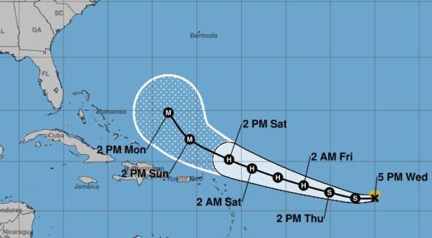 Tropical Storm Erin’s track as of 5 p.m., Wednesday, August 13, 2025. (Courtesy NHC)
“Bermuda could be soaked with 2 to 4 inches of rain and wind gusts of 60 to 80 mph when Erin passes by the island next week,” said AccuWeather lead hurricane expert Alex DaSilva.
Erin would be the first Atlantic hurricane of the season and is the fourth tropical storm.
The average date for the first hurricane is Aug. 11.
A subset of scenarios show a threat to the east coast, but even without a direct strike, the coast still may feel marine effects. “Erin will churn up rough surf and dangerous rip currents along the Atlantic coastline from Florida all the way north to Maine starting this weekend into next week,” DaSilva said Tuesday. “Beach erosion is possible in some areas. A major hurricane in the open Atlantic can produce very rough surf that will impact beaches hundreds of miles away. Hazardous beach conditions are likely across parts of the Caribbean, Bahamas and Bermuda.”
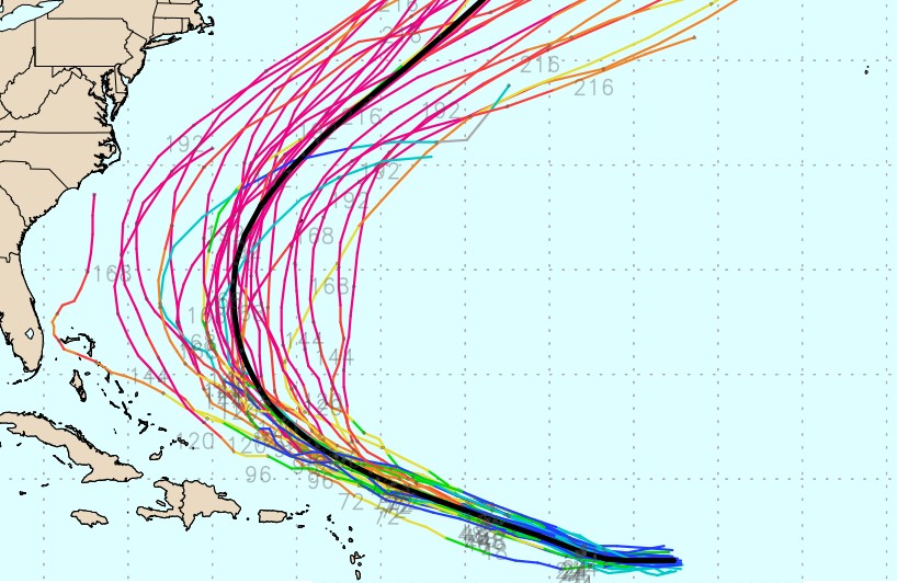
If the storm stays weak, then strengthens near the Bahamas, it could affect the U.S. East Coast. A South Florida impact would be the least likely scenario: As of Tuesday, most forecast tracks — known as the “spaghetti models” — show the turn coming well before reaching the U.S. coast. But many of those tracks have moved that turn a bit closer to the U.S. than previous runs.
Forecasters warned that long-range forecast tracks commonly swing back and forth, and Erin’s forecast path is likely to continue shifting.
An area of low pressure has formed in the southwestern Gulf, near Honduras and Nicaragua. It is expected to move west-northwest across the water into Thursday morning, where conditions are slightly more favorable for it to develop, forecasters said.
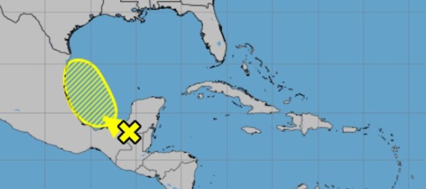 A system is expected to move across the southwestern Gulf overnight Wednesday, Aug. 13, 2025, the National Hurricane Center said.
Forecasters expect it to move over northeastern Mexico by late Friday, which would end any chances for it to develop.
It has a 20% chance of developing in the next two to seven days, the hurricane center said.
Originally Published: August 13, 2025 at 7:10 AM EDT