
An unseasonably strong storm is forecast to tap into an atmospheric river and drop several inches of rain across British Columbia, Washington and Oregon from Thursday night through Saturday.
Baron/Lynx
Two separate weather patterns are forecast to bring substantial rainfall to parts of the West the next few days, alleviating drought and drenching wildfires from Seattle to Phoenix.
An early-season atmospheric river could drop nearly a month’s worth of precipitation across drought-plagued Washington state, Oregon and British Columbia from Thursday night through Saturday. The same storm will bring showers to Western Oregon on Friday and thunderstorms to far Northern California on Saturday and Sunday.
Article continues below this ad
A revitalized North American Monsoon will raise the chance of thunderstorms and wetting rain across Arizona, New Mexico, Utah and Colorado from Thursday through Saturday. Phoenix could pick up its first measurable rainfall in more than six weeks.
Here’s what to know about how the forthcoming rainfall could mitigate drought and fires:
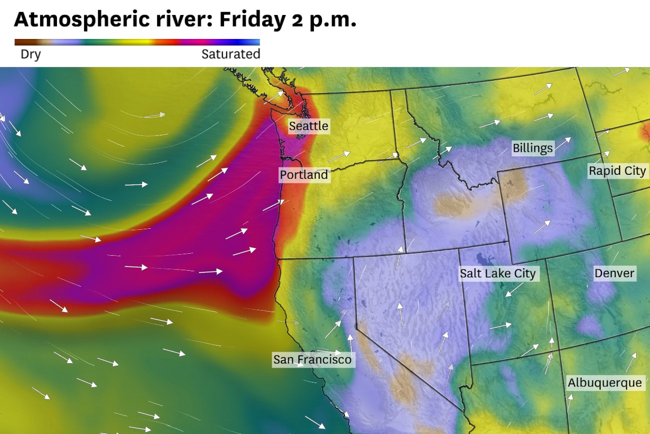
Unseasonable Pacific Northwest atmospheric river
An unseasonably strong low-pressure system is expected to move toward British Columbia on Thursday. This storm will usher a moisture-rich atmospheric river toward Seattle on Friday, setting the stage for significant mountain precipitation, weather more typical of November than August.
Weather models predict precipitable water — the amount of water vapor in the atmosphere — will approach record levels over Washington state and Oregon not just for August, but any time of year.
Article continues below this ad
A month’s worth of rain is forecast to fall in one day in Western Oregon and Washington state. Mountain ranges in these states are forecast to receive 2 to 6 inches of precipitation by Saturday afternoon. Some Washington cities, such as Olympia, Bellingham and Quillayute, could set daily rainfall records, with amounts ranging from 1 to 3 inches. Totals in Seattle and Portland, Ore., will be on the lighter side, but each city could still pick up an inch of rain by Saturday afternoon.
About an inch of rain is forecast to fall in Portland, Ore., and Seattle, with 2 to 6 inches in the mountains. The heaviest rain is expected Friday, but showers are likely to continue Saturday.
Baron/Lynx
Light snowfall is forecast atop Mount Rainier, Washington’s tallest mountain.
Wildfire activity ramped up in drought-plagued areas, and the rain should help firefighters with containment efforts. Around an inch of rain is forecast to douse the Bear Gulch Fire west of Seattle, which has sent plumes of smoke drifting across the region in recent days. Similarly, the Mount Underwood Fire on Vancouver Island that began Aug. 11 and exploded to more than 5,000 acres in two days is expected to receive significant rainfall.
Active monsoon returns to Arizona
Much of the Desert Southwest gets a significant portion of its annual rainfall from summer thunderstorms, but this year’s monsoon has been subdued, particularly in Arizona. After a quiet few weeks, monsoon thunderstorms should become more active across Arizona and New Mexico through the weekend.
Article continues below this ad
Nearly two-thirds of the West is experiencing moderate drought or worse, according to the Aug. 7 U.S. Drought Monitor update. Mid-August rain could help alleviate drought conditions in the Pacific Northwest and Desert Southwest.
Baron/Lynx
Phoenix has received less than 20% of normal monsoon rainfall and fewer lightning strikes than any summer since at least 1990. That should change Thursday, when a mesoscale convective vortex lifts across Arizona on Thursday and could bring measurable rain to Phoenix. By Friday, a strong surge of moisture from the Gulf of California is expected to trigger a thunderstorm outbreak across Arizona and New Mexico, lasting through Saturday, according to the University of Arizona meteorology department.
The precipitation could help moisten vegetation and dampen wildfires across Arizona. Critically dry fuels in July and early August contributed to fast-growing blazes, including the Dragon Bravo Fire, which continues to spread after destroying a historic lodge in Grand Canyon in early July.
What about California?
The monsoon high is expected to be too far east for rain in Southern California, but the remnants of the atmospheric river may hold together just enough for showers in far Northern California this weekend.
Article continues below this ad
Mountainous areas north of Redding have the best chance of picking up a quarter- to half-inch of rain from passing showers Saturday and Sunday. Rainfall totals may be locally heavier beneath thunderstorms, especially around Mount Shasta.
While the Bay Area isn’t in line for heavy rain like the Pacific Northwest, the storm will still impact weather around San Francisco.
Breezy winds are predicted to mix out the fog in San Francisco from Thursday evening until Friday afternoon. Gusts up to 40 mph are possible along the coast.
Baron/Lynx
Moisture and some high-level clouds associated with the system are anticipated to drift all the way over the Bay Area throughout the weekend. However, there won’t be enough vertical motion in the atmosphere to condense the water vapor to liquid raindrops.
Ahead of the system, the pressure gradient along the California coast will tighten and whip up moderate northwesterly winds. These winds may be accompanied by enough dry air to mix out the coastal fog by Thursday evening for a mainly clear night over San Francisco Bay. Friday may even begin mostly sunny in San Francisco. Despite the sunshine, northwest gusts up to 35 mph are expected in the city. Even stronger gusts are possible in Point Reyes and through the San Bruno Gap.
Article continues below this ad
As winds ease Friday night, marine layer clouds are expected to redevelop and blanket San Francisco Peninsula by Saturday morning. The thick marine layer will extend far inland over the weekend, keeping temperatures on the cool side of normal.