
IMPACT: Code Red air quality alert in effect as Canadian wildfire smoke settles across Pennsylvania
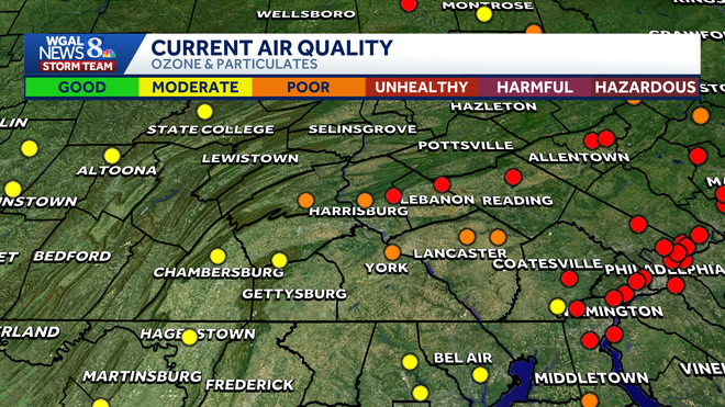
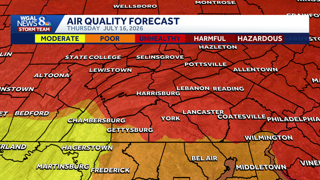
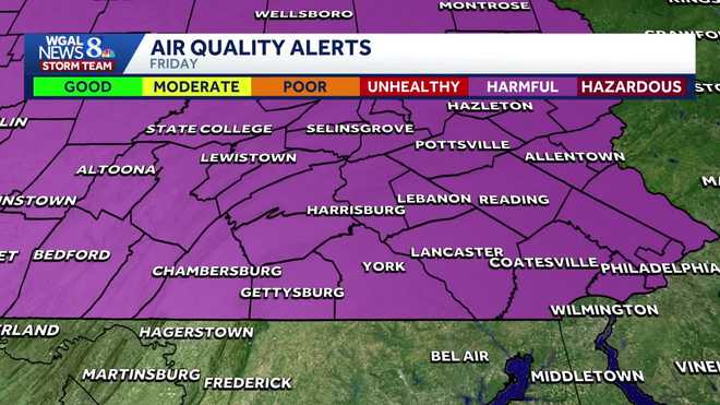
That pregnant people are also at higher risk when the air is this bad, and we’re now going to check in with meteorologist Ethan Houston. Thank you, Susan, and unfortunately this air quality is only going to get worse as we go through tonight and for tomorrow. So we go from *** code red to *** code purple through the day tomorrow. So the concentration of the air pollution from the Canadian wildfire smoke is going to increase, and we’re taking *** live look right now over Harrisburg. Usually when we’re looking. Off to northwest on our sky came, you can see the ridge of the Blue Mountain, the Dolphin Narrows, and now you can barely just see past City Island as we have that thick, acrid smoke that is overhead across much of the Susquenna Valley at *** concentration that is unhealthy for all. 94 right now in Harrisburg and it still feels like it’s 96 despite the fact we do have *** stiff breeze out there. Here’s *** look at the current air quality across the region where you see the red, that’s considered unhealthy, *** little bit better. The farther south you go, *** slight improvement, just moderate across much of Lancaster County, York County, Adams County, and Franklin County. But for you folks up in Mifflin County and toward the center county line, downright harmful, and I do expect that is going to be the case as we go through the day tomorrow. So we’ve got that code red still in effect. So right now, unhealthy for all, it certainly could cause some issues, could cause some coughing, stinging eyes, and breathing difficulties. So limit your time outdoors if you can. It is also inhibiting thunderstorm development just because it’s just acting like *** lid on the atmosphere right now, so we’ll have that thick haze and passing clouds and temperatures in the 90s with that muggy high humidity that will be around through the night tonight. And again, the thicker wildfire smoke that is impacting northern Pennsylvania, that’s what slides overhead tomorrow. Temperatures will still manage to top off right around 90 degrees, so that is why we have *** code purple tomorrow. You notice there on the scale that is. Harmful, potentially harmful for all. So limit your time outdoors again, coughing, stinging eyes, breathing difficulties out there. Keep the windows and doors closed and want to keep the HVAC system, if you have that on recirculated air. So there’s the wildfires over Ontario and northern Minnesota, and it’s just like being at the end of *** garden hose. It’s just the jet stream that’s bringing that thick wildfire smoke down into the heart of the Susquenna Valley where you see that purple shade. Those are the high concentrations that. Be overhead much of our Friday. We’ll finally start to see *** shift in the winds thanks to an approaching storm system. So notice the thick smoke starts to lift off to the northeast and our air quality will improve on Saturday. However, storm chances will then begin to rise. So tomorrow, very unhealthy air quality, moderate levels of smoke in the air for your Saturday and Sunday, also on into Monday. Got *** little bit of *** light breeze out there right now, anywhere from 5 to 15 MPH, but it still feels very hot and humid. Feels like it’s 100 in Elizabethtown. In Africa it feels like it’s 100 in Dover. Here the actual air temperatures 94 right now in Harrisburg, despite that thick smoke, 90 degrees currently in Lancaster. We do have cooler air off to our north, but remember, northern Pennsylvania is where the smoke is currently at its thickest right now, just 79 in Bradford. But you can see that drier air on the backside of that cold front. Dew point is now down to 57 in Scranton, still 73 in Baltimore. So we’ve got *** front right, I’d say very close to. 80s, so that front’s going to move on by through this evening on into tonight, so it will feel less intense humid, but again, that thick smoke will be overhead with some passing clouds heading into Saturday. Here comes the storm system from the west, so some spotty showers will be possible late in the morning, but better chances for scattered showers and thunderstorms will be out there as we head through Saturday afternoon, and some of those storms could be strong to severe. On *** scale of 1 to 5, it’s *** level 2, and the window of opportunity looks to be between 2 o’clock and midnight. What we’ll have to watch out for are storms that produce damaging wind gusts and very heavy downpours that could lead to some flash flooding. So we go from poor air quality to potentially some strong thunderstorms for your Saturday. Fewer storms are likely on Sunday, and finally temperatures level off. Notice as we go through next week, highs will be in the mid to upper 80s each day. After Saturday, the next best chance for passing showers and thunderstorms will return Tuesday. All right, thank you.
IMPACT: Code Red air quality alert in effect as Canadian wildfire smoke settles across Pennsylvania

Updated: 5:44 PM EDT Jul 16, 2026
A Code Red air quality alert is in effect for south-central Pennsylvania on Thursday as thick wildfire smoke moves into the region, creating unhealthy conditions, according to the Pennsylvania Department of Environmental Protection. The WGAL News 8 Storm Team has declared Thursday an Impact Day, meaning the weather is likely to disrupt your normal daily schedule or routine. Canadian wildfire smoke Smoke from wildfires burning in southern Ontario and northern Minnesota is spreading across the Great Lakes and Northeast. That smoke is now concentrated near the surface, making air quality unhealthy across central and southeastern Pennsylvania. Below: Near-surface smoke forecast in south-central PennsylvaniaThe smoke is expected to create hazy skies and reduce sunshine, keeping temperatures slightly lower than they otherwise would be, though conditions will still be hot and humid. Code Red in effect Thursday A Code Red alert means air pollution has reached levels considered unhealthy for everyone, not just sensitive groups. The alert covers the entire Susquehanna Valley for Thursday. Officials warn the smoky air can cause:Itchy or burning eyesCoughingDifficulty breathingWorsening symptoms for people with asthma or other respiratory conditionsResidents are being urged to limit outdoor exercise and avoid strenuous activity outside while the alert remains in effect. The last Code Red air quality alert issued for the region was in June 2023. Thursday’s high is expected to reach about 92 degrees, with humidity making it feel like the mid- to upper 90s. No heat alerts are in effect. Conditions linger Friday, Code Purple issuedA Code Purple air quality alert will be in effect for south-central Pennsylvania on Friday as thick wildfire smoke continues to swirl across the region, creating potentially harmful conditions for everyone, according to the Pennsylvania Department of Environmental Protection.The WGAL News 8 Storm Team has declared Friday an Alert Day, meaning the day could feature potentially life-threatening weather.A Code Purple is worse than a Code Red air quality alert, which is in effect Thursday.What does a Code Purple mean?Air quality is very unhealthy/harmful for all.Possible effects include:CoughingStinging eyesBreathing difficultiesFriday’s high is expected to be near 90 degrees. Scattered showers and thunderstorms are possible Saturday, which could help improve air quality heading into the weekend. Safety precautionsHealth officials recommend that residents, especially children, older adults and those with heart or lung disease, take precautions during smoky conditions.Recommended steps include:Limit time outdoorsAvoid strenuous outdoor activityKeep windows closed if possibleUse air conditioning on recirculateMonitor symptoms such as coughing or shortness of breathCheck local air quality sensors and forecasts before going outsideThe WGAL News 8 Storm Team will continue to monitor the forecast and provide updates as they become available. Check live conditions around the Valley
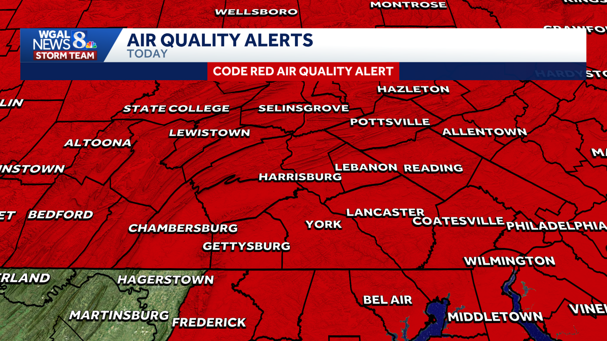
A Code Red air quality alert is in effect for south-central Pennsylvania on Thursday as thick wildfire smoke moves into the region, creating unhealthy conditions, according to the Pennsylvania Department of Environmental Protection.
The WGAL News 8 Storm Team has declared Thursday an Impact Day, meaning the weather is likely to disrupt your normal daily schedule or routine.
Canadian wildfire smoke
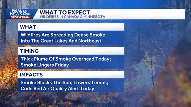
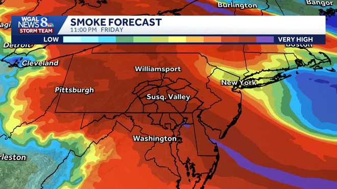
Smoke from wildfires burning in southern Ontario and northern Minnesota is spreading across the Great Lakes and Northeast.
That smoke is now concentrated near the surface, making air quality unhealthy across central and southeastern Pennsylvania.
Below: Near-surface smoke forecast in south-central Pennsylvania
The smoke is expected to create hazy skies and reduce sunshine, keeping temperatures slightly lower than they otherwise would be, though conditions will still be hot and humid.
Code Red in effect Thursday
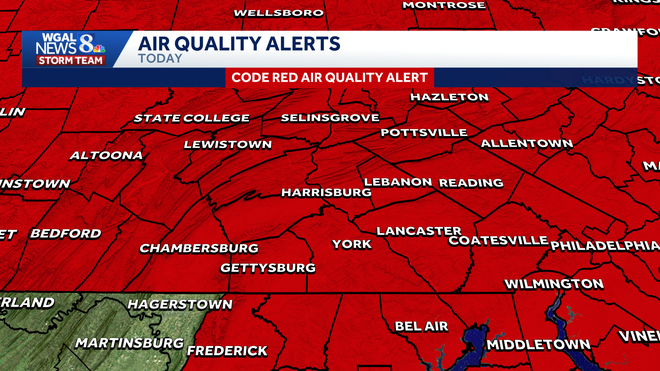
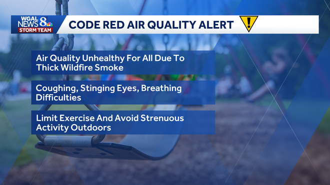
A Code Red alert means air pollution has reached levels considered unhealthy for everyone, not just sensitive groups. The alert covers the entire Susquehanna Valley for Thursday.
Officials warn the smoky air can cause:
Itchy or burning eyesCoughingDifficulty breathingWorsening symptoms for people with asthma or other respiratory conditions
Residents are being urged to limit outdoor exercise and avoid strenuous activity outside while the alert remains in effect.
The last Code Red air quality alert issued for the region was in June 2023.
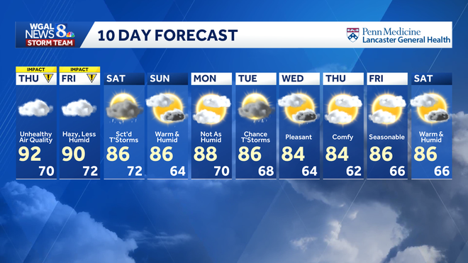
Thursday’s high is expected to reach about 92 degrees, with humidity making it feel like the mid- to upper 90s. No heat alerts are in effect.
Conditions linger Friday, Code Purple issued
A Code Purple air quality alert will be in effect for south-central Pennsylvania on Friday as thick wildfire smoke continues to swirl across the region, creating potentially harmful conditions for everyone, according to the Pennsylvania Department of Environmental Protection.
The WGAL News 8 Storm Team has declared Friday an Alert Day, meaning the day could feature potentially life-threatening weather.
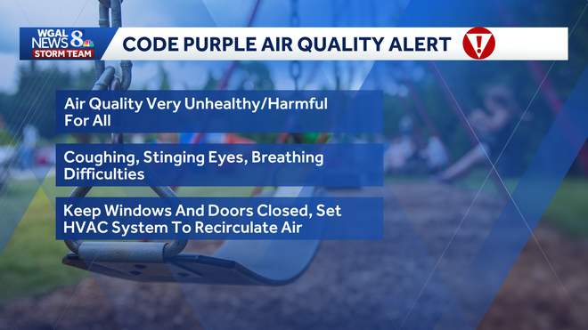
A Code Purple is worse than a Code Red air quality alert, which is in effect Thursday.
What does a Code Purple mean?Air quality is very unhealthy/harmful for all.Possible effects include:CoughingStinging eyesBreathing difficulties
Friday’s high is expected to be near 90 degrees.
Scattered showers and thunderstorms are possible Saturday, which could help improve air quality heading into the weekend.
Safety precautions
Health officials recommend that residents, especially children, older adults and those with heart or lung disease, take precautions during smoky conditions.
Recommended steps include:
Limit time outdoorsAvoid strenuous outdoor activityKeep windows closed if possibleUse air conditioning on recirculateMonitor symptoms such as coughing or shortness of breathCheck local air quality sensors and forecasts before going outside
The WGAL News 8 Storm Team will continue to monitor the forecast and provide updates as they become available.
Check live conditions around the Valley