
Tropical Storm Bertha expected to make landfall as it moves along northern Gulf Coast
Weather video there. OK, well, we are having *** little bit of *** flood risk here in New Orleans, but most of the heavy rains due to Bertha, which has 50 mile an hour winds, are displaced to the south of the center of circulation, which is about 45 miles from the mouth of the Mississippi River. The current movement to the west at 5 miles an hour, which puts it on *** beeline for that New Orleans landfall perhaps, or at least maybe earlier some of those southern Louisiana parishes even south of New. New Orleans sometime later this afternoon and basically the real risk is going to be this push of water because of all the energy out in the Gulf and so that would mean some storm surge 1 to 3 ft. But again, the heaviest of the rains, we don’t really have much rain band action out there right now. It’s in the Gulf waters that are open, so *** sky camera network here in contrast is showing very calm seas, the Atlantic Ocean looking good, the beach looking inviting, yet it already. It seems hot out there and that it is. We’re going to see daytime highs in the 90s again with real field conditions or what we call the heat index, that combination of heat and humidity up in the middle 9 up in the low 100s I should say with actual highs close to the middle 90s. We hit 92 yesterday. 99 is the record. It was set back in 1942, so it’s secure, I think, for another year though we do have pockets of extreme and major heat risk. Case in point, it already with the heat index is 102 in Okeechobee, combination of heat and humidity in West Palm 97, 97 Jupiter, 95, Boca 97 in Indiantown. Your 12 hour forecast is showing us with the low 90s again on the horizon today. Looks like *** chance of some showers at about 20-30% maybe later on this afternoon, but if I pull things out now on our first warning radar, you can see it’s pretty quiet. We did see *** few s. Southeast showers moving in and we see some action just skirting the coastline kind of flirting with us right now, but nothing too significant so it looks good. By Friday we’re starting to populate first warning radar *** little bit more for the modeling as we head into the latter part of the afternoon and the evening. We’re going to see *** more widespread storm potential as we get on through Friday and not only that, but Saturday, Sunday, and even into next week. So I consider it ***. *** much wetter pattern next week. Nothing, you know, complete washout status, but we will see each day and evening showers and storms on the stronger side, most likely. So here’s *** look at what we have going forward for beach and boating. Take advantage of it while you can. Southeast winds 10 to 15 knots, 87 degree water temperatures, and with that easterly wind component, we do have that risk of rip currents. So be careful. Low tide we just had and high tides next at 3:45 this afternoon. Well, West Palm Beach
Weather video there. OK, well, we are having *** little bit of *** flood risk here in New Orleans, but most of the heavy rains due to Bertha, which has 50 mile an hour winds, are displaced to the south of the center of circulation, which is about 45 miles from the mouth of the Mississippi River. The current movement to the west at 5 miles an hour, which puts it on *** beeline for that New Orleans landfall perhaps, or at least maybe earlier some of those southern Louisiana parishes even south of New. New Orleans sometime later this afternoon and basically the real risk is going to be this push of water because of all the energy out in the Gulf and so that would mean some storm surge 1 to 3 ft. But again, the heaviest of the rains, we don’t really have much rain band action out there right now. It’s in the Gulf waters that are open, so *** sky camera network here in contrast is showing very calm seas, the Atlantic Ocean looking good, the beach looking inviting, yet it already. It seems hot out there and that it is. We’re going to see daytime highs in the 90s again with real field conditions or what we call the heat index, that combination of heat and humidity up in the middle 9 up in the low 100s I should say with actual highs close to the middle 90s. We hit 92 yesterday. 99 is the record. It was set back in 1942, so it’s secure, I think, for another year though we do have pockets of extreme and major heat risk. Case in point, it already with the heat index is 102 in Okeechobee, combination of heat and humidity in West Palm 97, 97 Jupiter, 95, Boca 97 in Indiantown. Your 12 hour forecast is showing us with the low 90s again on the horizon today. Looks like *** chance of some showers at about 20-30% maybe later on this afternoon, but if I pull things out now on our first warning radar, you can see it’s pretty quiet. We did see *** few s. Southeast showers moving in and we see some action just skirting the coastline kind of flirting with us right now, but nothing too significant so it looks good. By Friday we’re starting to populate first warning radar *** little bit more for the modeling as we head into the latter part of the afternoon and the evening. We’re going to see *** more widespread storm potential as we get on through Friday and not only that, but Saturday, Sunday, and even into next week. So I consider it ***. *** much wetter pattern next week. Nothing, you know, complete washout status, but we will see each day and evening showers and storms on the stronger side, most likely. So here’s *** look at what we have going forward for beach and boating. Take advantage of it while you can. Southeast winds 10 to 15 knots, 87 degree water temperatures, and with that easterly wind component, we do have that risk of rip currents. So be careful. Low tide we just had and high tides next at 3:45 this afternoon. Well, West Palm Beach
Tropical Storm Bertha expected to make landfall as it moves along northern Gulf Coast

Updated: 10:16 AM EDT Jul 22, 2026
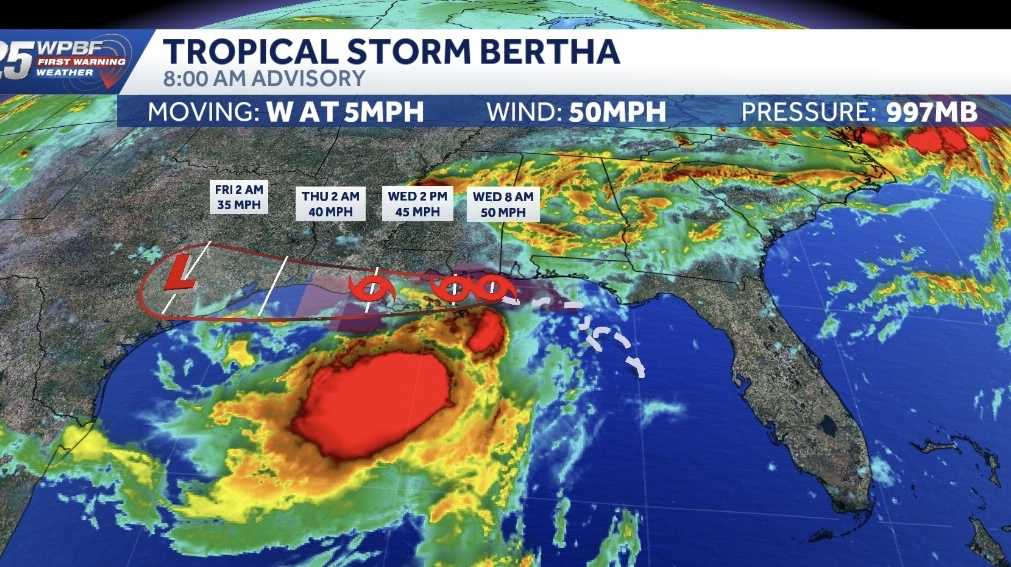
The WPBF 25 First Warning Weather team is tracking Tropical Storm Bertha as it moves along the northern Gulf Coast. Bertha is expected to approach New Orleans Wednesday afternoon, where a 2-to-4-foot storm surge is possible.As of the 8 a.m. advisory, it was located about 45 miles northeast of the mouth of the Mississippi River and about 60 miles south of the mouth of the Pascagoula River.Bertha was moving west at 5 mph with 50 mph maximum sustained winds. Tropical Storm WarningOkaloosa/Walton County Line in Florida to Morgan City, LouisianaMetropolitan New Orleans and Lake Pontchartrain Tropical Storm WatchWest of Morgan City, Louisiana, to Sargent, TexasLake Maurepas The NHC said the combination of storm surge and the tide will cause normally dry areas near the immediate coast to be flooded by rising waters moving inland from the shoreline.Tracking the TropicsTropical Storm Arthur was the first named storm of the 2026 Atlantic hurricane season. Arthur reached tropical storm strength June 17, with winds of 45 mph in the Gulf close to the Texas coastline. Stay with WPBF 25 on air and online for updates. Interactive radarSevere Weather AlertsDownload the WPBF 25 News app for the most up-to-date weather alerts.
The WPBF 25 First Warning Weather team is tracking Tropical Storm Bertha as it moves along the northern Gulf Coast.
Bertha is expected to approach New Orleans Wednesday afternoon, where a 2-to-4-foot storm surge is possible.
As of the 8 a.m. advisory, it was located about 45 miles northeast of the mouth of the Mississippi River and about 60 miles south of the mouth of the Pascagoula River.
Bertha was moving west at 5 mph with 50 mph maximum sustained winds.
Tropical Storm Warning
Okaloosa/Walton County Line in Florida to Morgan City, LouisianaMetropolitan New Orleans and Lake Pontchartrain
Tropical Storm WatchWest of Morgan City, Louisiana, to Sargent, TexasLake Maurepas
The NHC said the combination of storm surge and the tide will cause normally dry areas near the immediate coast to be flooded by rising waters moving inland from the shoreline.
Tracking the Tropics
Tropical Storm Arthur was the first named storm of the 2026 Atlantic hurricane season. Arthur reached tropical storm strength June 17, with winds of 45 mph in the Gulf close to the Texas coastline.
Stay with WPBF 25 on air and online for updates.
Download the WPBF 25 News app for the most up-to-date weather alerts.