
Every day, the Ukraine Battlefield update newsletter offers a clear look at how the war is unfolding on the ground. Subscribe for free here to get the full text delivered to your inbox.
The 3rd Army Corps is trying to cut off a Russian salient in northern Donetsk region. It is close to succeeding. “Manoeuvre warfare is not dead. And today, on Independence Day, Ukraine proved it. Albeit only on a limited scale. On one section of the front, one Ukrainian brigade used four infantry fighting vehicles during an assault. They managed to penetrate as much as three km deep, deploy infantry, and all the vehicles returned. And this all happened on a perfect sunny day, when drones are constantly flying around and attacking something. How did they manage to avoid being stopped by drones? The battlefield was prepared for it,” Ukrainian veteran Dmytro Putiata said on his account on Monday (24 August) afternoon, without providing further details.
For years, we knew him by the nickname Kriegsforscher. In Slovak, it means Military Analyst.
Of course, this involved only three km and four pieces of heavy equipment, so the statement that manoeuvre operations are not dead may appear disproportionate. Had someone used it in 2022 with these figures, it would not have referred to anything significant at all. Essentially, this was a small, platoon-level operation. Analysts therefore genuinely began debating whether Putiata was exaggerating.
But it is important to recognise that the circumstances have changed completely and, given the current reality on a front entirely dominated by drones, this can genuinely be described as a successful mechanised operation.
He said it had been enabled by cooperation between drones and artillery. Moreover, it took place on an important axis that forms part of the broader battle for the Sloviansk/Kramatorsk agglomeration.
Alongside events in Dnipropetrovsk region, where Ukrainians announced the liberation of 26 settlements in mid-August, this is the second of two counter-offensives about which little had been known.
The significance of this second one may be even greater, because if it can indeed be brought to a successful conclusion, it will prevent the Russians from attempting a breakthrough in Donbas north of Sloviansk. Paradoxically, one of the most active sources reporting on it was the Russian Rybar.
Over the weekend and repeatedly on Monday, it wrote that the Ukrainian army was continuing counter-attacks in the Lyman direction, with fighting taking place near the village of Korovyi Yar, “in the north of our salient”.
On Rybar’s map, the Ukrainians are trying to cut off the Russian salient at the village of Shandryholove, towards which blue arrows converge from the south and north. As we will show below, although Rybar is one of the few Russians to acknowledge problems, this map too is highly inaccurate and misleading.
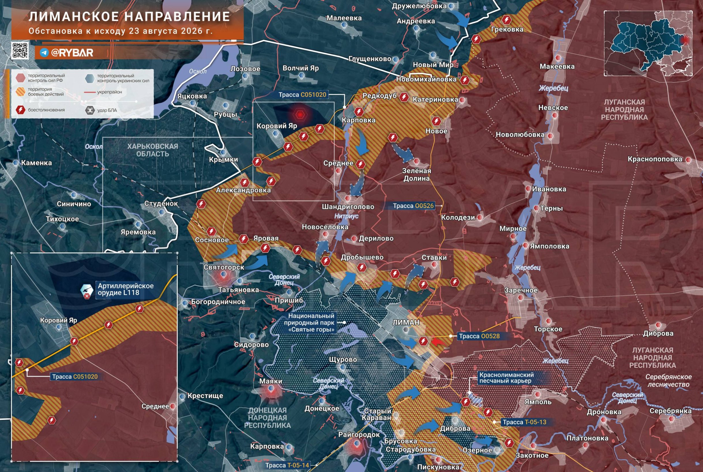
However, the fighting is very likely taking place even further east, specifically near the village of Kolodiazi — more than 10 km deeper into Russian positions. Several analysts identified it as the site of the attack first reported by Putiata.
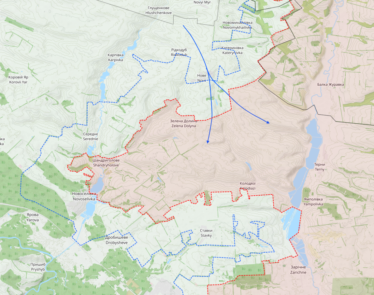
The Polish analytical account Thorkill, which is often sceptical of Ukrainian claims and frequently disputes assessments with other analysts, claimed shortly before midnight on Monday that the Ukrainian army’s 3rd Army Corps “is close to eliminating the Russian 20th Army’s bridgehead on the western bank of the Zherebets river. A Ukrainian assault on the Kolodiazi area is under way from both the north and the south.”
Sytuacja w rejonie Nowego (Łyman), część II.
Jednym z odcinków frontu w Donbasie, na którym wojska ukraińskie prowadzą obecnie działania zaczepne, jest rejon Kateryniwka – Nowe – Zełena Dolyna, na północ od Łymanu. Od połowy maja 2026 r. pozycje rosyjskiej 144 Dywizji Strzelców… pic.twitter.com/AIvInwHGX3
— Thorkill (@Thorkill65) August 25, 2026
When comparing Thorkill’s map with Rybar’s, it immediately becomes apparent that the Russians place Shandryholove in the middle of their salient, whereas in the other case it forms its westernmost part.
The Finns at Black Bird Group clearly side with the Pole on this point. As for the battle near Kolodiazi, they are more cautious, indicating it only through an attack from the north in two directions.
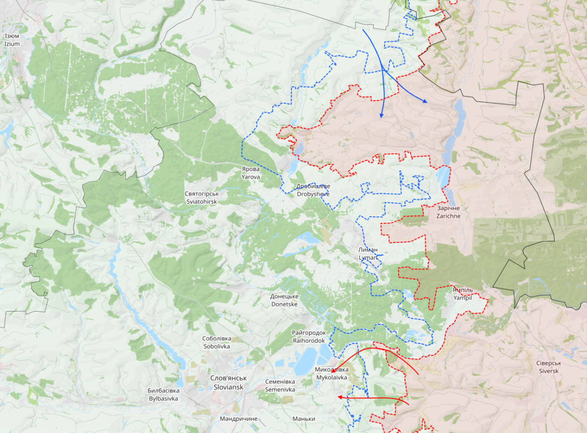
On a broader scale, the wider context of the operation is clearly visible. At this point, there was a risk that the Russians would push further west, bypassing Lyman and, together with it, Sloviansk and Kramatorsk from the north. They would also have entered Kharkiv region on a new section of the front. If the operation succeeds, all these risks will be at least temporarily averted.
The Russians are eight and a half km from Kramatorsk’s eastern boundary. “In the Kramatorsk-Sloviansk direction, the enemy advanced in the areas of Tykhonivka, Malynivka and south of Dibrova. At the same time, attacks are continuing along the Siverskyi Donets–Donbas canal towards Vasutynske and Nykanorivka, as well as around Rai-Oleksandrivka and Dovhyi Forest,” the Ukrainian Petrenko account reported on Monday afternoon.
Malynivka and Tykhonivka lie on the western bank of the canal mentioned above. This means the Russians have already established positions beyond this obstacle, and both settlements will serve them as bridgeheads for further advances towards the city.
Petrenko’s map clearly shows what is preventing them from advancing further for now. A strong Ukrainian defensive position blocks them from linking up the salients at Malynivka and Tykhonivka. Immediately beyond the villages is a belt containing an anti-tank ditch and other engineering obstacles.
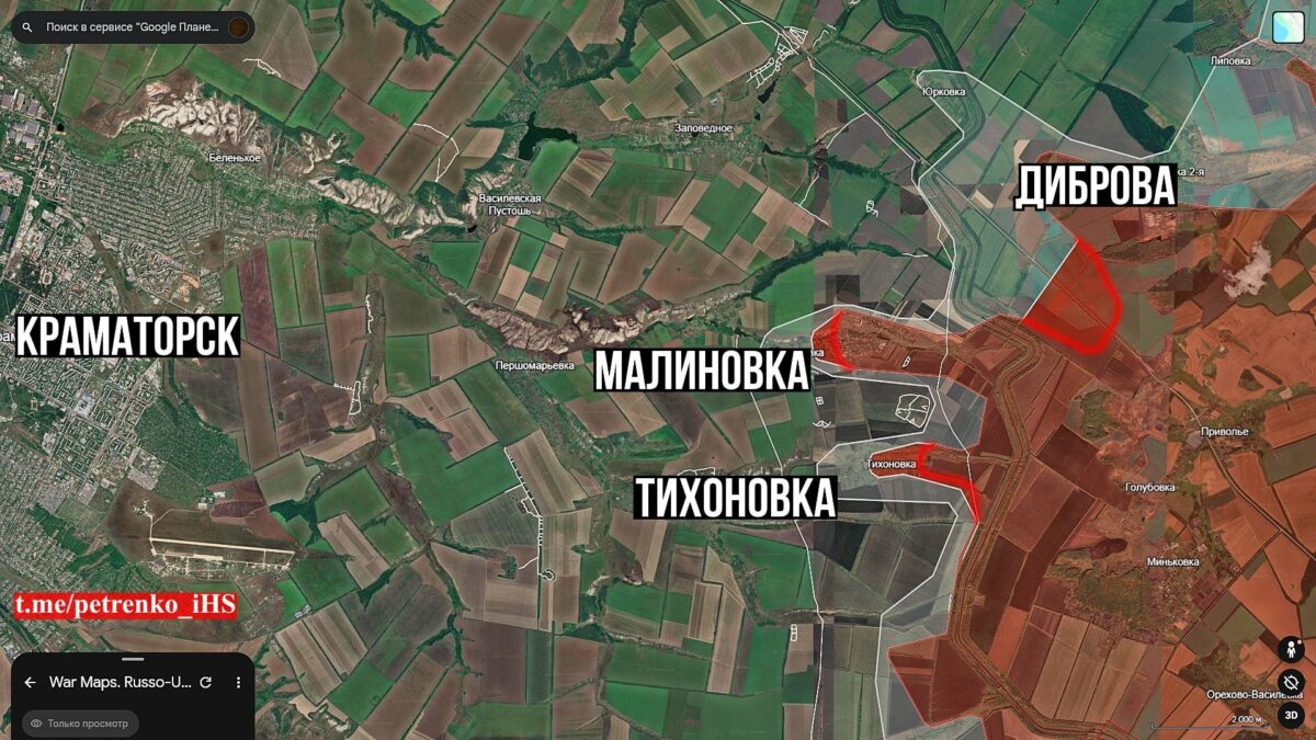
The Sloviansk-Kramatorsk agglomeration is thus slowly but surely reaching the point at which direct fighting for both cities will begin. As we wrote last Friday, they have five km to cover to reach the administrative boundary of the first of them, and 13 km to its centre. In Kramatorsk’s case, they are eight and a half km from its boundary.
The Russians are trying to create a pocket in Kharkiv region, but for now there are only signs of one. Ukrainian analyst Bohdan Myroshnykov outlined its contours in his post. This is a less closely watched direction. Its individual sections have different histories.
To the north lies the city of Vovchansk, near Kharkiv. Fighting here began in spring 2024, when the Russian army launched an operation that initially appeared to be the beginning of a second battle for Kharkiv.
Despite initial confusion and mistakes, however, the Ukrainian army quickly managed to halt the Russian advance, and the Russian offensive turned into grinding fighting for the city of Vovchansk, which was subsequently completely destroyed and occupied at the turn of 2025 and 2026.
The other locations on the map show Russian incursions across the state border, aimed at stretching and exhausting Ukrainian defences while also linking the battlefield near Vovchansk with the sector near the village of Dvorichne on the western bank of the Oskil. The two locations are almost 70 km apart in a straight line, so this is a fairly large area.
Kupiansk is not visible on Myroshnykov’s map, but it lies a short distance south of Dvorichne, and the author has repeatedly warned that the situation on the eastern bank of the Oskil near Kupiansk “is approaching collapse”.
Ворог продовжує спроби зʼєднати Вовчанськ з Дворічною одним великим плацдармом.
Для цього вони ведуть бої за прикордоння, яке переважно нагадує сіру зону.
Так, в минулому році певні точки були посилені.
Але прориви накшталт того, що сталося в районі Артільного, Дегтярного та… pic.twitter.com/d6rSqaLuXk
— Василь Стус (@v_stus) August 24, 2026
An unusual MiG-29 manoeuvre over Odesa. “I watched eight times to see what he was trying to do, but he did nothing in this video … Yet the drone fell,” Russian Telegram channel Fighterbomber commented on the Ukrainian pilot’s behaviour in the video below. Its author is himself a military pilot, and the footage from Odesa caught his attention. It ends with a Russian drone crashing to the ground.