
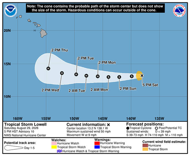
UPDATE: 11 p.m.
Tropical Storm Lowell continued moving west Saturday night as forecasters expect it to strengthen into a hurricane by Monday.
As of 11 p.m., Lowell was about 1,150 miles east-southeast of Hilo, with maximum sustained winds of 50 mph. It was moving west at 10 mph.
Wind shear is still limiting Lowell’s organization, but conditions are expected to improve over the next day or so, allowing the storm to strengthen more quickly. Its longer-term track remains uncertain because of the potential influence of Hurricane Karina to the northeast.
Karina, meanwhile, has strengthened into a hurricane with maximum sustained winds of 80 mph. At last check, it was about 1,000 miles southwest of Baja California and moving west-northwest at 15 mph.
Karina is expected to continue strengthening and could become a major hurricane within a day or so before gradually weakening later in the week as it moves over cooler waters and into drier air.
Don’t miss out on what’s happening!
Stay in touch with breaking news, as it happens, conveniently in your email inbox. It’s FREE!
No coastal watches or warnings are in effect for Lowell, and there are no current hazards affecting land.
5:30 p.m.
Tropical Storm Lowell strengthened slightly this afternoon and is forecast to be a powerful Category 2 hurricane a few hundred miles south of Hawaii island by late next week.
As of about 5 p.m., Lowell was centered 1,210 miles east-southeast of Hilo with 50 mph maximum sustained winds and moving west at 9 mph in the East Pacific, according to the National Hurricane Center. Tropical storm-force winds of 39 mph or more extend up to 70 miles from Lowell’s center.
The updated five-day forecast map shows Lowell entering the Central Pacific Sunday then growing into a hurricane with 110 mph winds by Thursday when it will be several hundred miles south of Hilo.
Lowell is one of two growing tropical cyclones in the East Pacific with the larger and more-powerful Karina nearing hurricane status hundreds of miles off the coast of Mexico.
Karina had 70 mph maximum sustained winds at 5 p.m. and was centered 780 miles west-southwest of the southern tip of Baja California, moving west-northwest at 16 mph, according to NHC. Tropical storm-force winds extend up to 300 miles from the center.
Karina is forecast to become a hurricane late tonight and reach Category 3 strength with 115 mph maximum sustained winds by Monday. It is then expected to steadily weaken after Tuesday as it remains far from land.
While Lowell is forecast to strengthen through next week, the hurricane center cautions that there is uncertainty in the long-term forecast “due to Lowell’s potential interaction with Karina.”
“The current forecast track keeps the cyclones sufficiently separated for Lowell to continue strengthening, while a slower and more northwestward solution could expose Lowell to stronger shear associated with outflow from Karina and result in a weaker cyclone,” forecasters said.
11:20 a.m.
Tropical Storm Lowell took a turn to the west-northwest this morning while maintaining its strength, but forecasters expect it to resume it’s westward trek toward the Central Pacific and grow into a hurricane.
As of about 11 a.m., Lowell was centered 1,275 miles east-southeast of Hilo with 45 mph maximum sustained winds and moving west-northwest at 13 mph in the East Pacific, according to the National Hurricane Center. Tropical storm-force winds extend up to 70 miles from Lowell’s center.
The updated five-day forecast map shows Lowell in the Central Pacific Sunday, becoming a hurricane Monday, and growing into a powerful Category 2 cyclone with 110 mph winds Wednesday and Thursday when it will be several hundred miles southeast of Hawaii island.
“A westward motion should resume during the next few hours and continue for the next several days,” forecasters said in the 11 a.m. forecast. “Maximum sustained winds are near 45 mph with higher gusts. Gradual strengthening is expected during the weekend, and Lowell could become a hurricane by Monday or Monday night.”
Closer to Mexico, Tropical Storm Karina was expected to become a hurricane by early Sunday and a major Category 3 storm with 115 mph winds by Monday.
At 11 a.m. today, Karina had 70 mph maximum sustained winds and was 730 miles southwest of the southern tip of Baja California, moving northwest, away from land, at 12 mph. Tropical storm-force winds extend up to 230 miles from the center.
By Thursday, Karina is expected to have weakened to a tropical storm far off in the East Pacific that poses no threat to land, according to NHC.
The hurricane center’s forecasters said one unknown is how the bigger, more powerful Karina will affect the development and movement of Lowell.
They said by the end of Lowell’s current forecast period on Thursday, “the intensity forecast becomes more uncertain due to Lowell’s potential interaction with Karina.”
“The (current) forecast intensity … calls for Lowell and Karina to stay far enough apart for Lowell to maintain its strength or keep strengthening. However, a slower forward motion could expose Lowell to stronger shear associated with outflow from Karina and cause a weaker storm,” forecasters said
PREVIOUS COVERAGE
Tropical Storm Lowell maintained its strength in the East Pacific overnight and is still on track to reach hurricane status in the Central Pacific by Monday.
Lowell had maximum sustained winds of 45 mph and was centered 1,370 miles east-southeast of Hilo as of about 5 a.m. today, according to the National Hurricane Center in Miami. It was moving west, toward the Central Pacific, at 8 mph. Tropical storm-force winds of 39 mph or more extend up to 70 miles, mostly to the west of the center.
“Gradual strengthening is expected during the weekend, and Lowell could become a hurricane by Monday or Monday night,” forecasters said.
The latest five-day forecast map shows Lowell in the Central Pacific Sunday and strengthening into a powerful Category 2 hurricane with 110 mph winds by Thursday, when it is several hundred miles southeast of Hawaii island.
Far to the east of Lowell, Tropical Storm Karina is also expected to grow into a strong hurricane over the next few days but remain far from land, the NHC said.
As of 5 a.m. today, Karina had maximum sustained winds of 65 mph and was centered 710 miles southwest of the southern tip of Baja California, moving northwest, away from land, at 12 mph. Tropical storm-force winds extend up to 230 miles from the center.
The only impact to land expected from Karina is higher surf in Baja, forecasters said.
Karina is expected to peak as a major Category 3 hurricane with 115 mph sustained winds on Monday, but weaken back to a strong tropical storm by Thursday, according to the five-day forecast.
The hurricane center’s forecasters said one unknown is how the bigger, more powerful Karina will affect the development and movement of Lowell as it moves closer to Hawaii.
They said by the end of Lowell’s current forecast period on Thursday, “the intensity forecast becomes more uncertain due to Lowell’s potential interaction with Karina … a faster westward track would likely keep the cyclones sufficiently separated and allow Lowell to continue strengthening, while a slower solution could expose Lowell to stronger shear associated with outflow from Karina.”
As the two cyclones churn in the Pacific, Hawaii is expected to enjoy warm, sunny weather in the coming week.
“Breezy trades continue well into next week. Showers will generally favor windward and mauka areas, particularly during the overnight through early morning hours each day,” the National Weather Service said this morning. “An uptick in moisture next week could increase shower activity.”
Honolulu is expected to see mostly sunny or partly cloudy skies with high temperatures in the upper 80s to low 90s through Wednesday. Showers will be scattered over the next few days, and winds will be from the east at 15 to 25 mph through Monday, forecasters said.