
A strengthening tropical depression is primed to become Hurricane Isaias and batter parts of the southern US this week with heavy rain and strong winds.
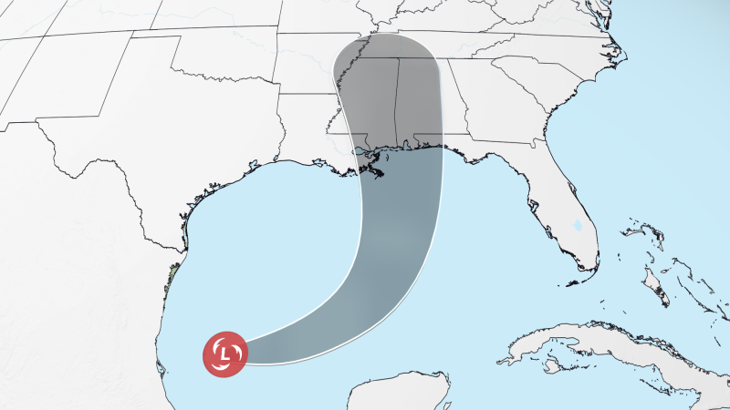
Tropical Depression Nine has sustained winds of 35 mph and was located about 600 miles south of the mouth of the Mississippi River as of Tuesday evening.
Get live updates and alerts.
Download the CNN Weather app.
The system is expected to push east above the Yucatan Peninsula and then turn sharply north toward the northern Gulf Coast. It’s forecast to strengthen quickly and become a Category 2 hurricane with 100 mph winds by Friday.
Isaias will likely usher in flooding rain, powerful winds and storm surge, to areas from southern Louisiana to the Florida Panhandle beginning on Friday. The storm could also spin up several tornadoes as its rainbands lash the coast.
This will be the first hurricane of the year in the Atlantic basin, ending a record-long wait tied to the effects of a likely record-strong El Niño.
Exactly where the storm could track or how strong it will be when it approaches land are still not set in stone, but anyone along the Gulf Coast from Louisiana to Florida’s Big Bend should monitor the forecast closely.
Florida Gov. Ron DeSantis declared a state of emergency for 25 counties Tuesday ahead of the storm, urging residents to prepare disaster plans and stock hurricane supply kits. State emergency teams are staging generators, fuel, food, water and flood barriers in the Tallahassee and Santa Rosa areas to support the response.
Oil companies are also taking precautions in the Gulf. Shell is evacuating nonessential personnel from six offshore platforms, while BP is removing nonessential workers and securing its offshore facilities, the companies said Tuesday.
This storm is making a run through El Niño-influenced atmospheric conditions that have largely stymied tropical systems throughout the Atlantic hurricane season so far. Gulf waters are record warm for this time of year, providing plenty of fuel, but that’s only part of the equation.
The bane of Atlantic tropical systems this season has been wind shear. This refers to winds blowing at different speeds and from different directions at several levels of the atmosphere. Wind shear can tear tropical storms and hurricanes apart.
This new system is benefitting from low wind shear in the southern Gulf, but it’ll find higher wind shear guarding the Gulf Coast to the north, threatening to shred the storm as it makes its approach.
But the system is also forecast to move quickly, so its exposure to the higher wind shear may be limited. If the storm were to move slower, it could weaken quickly as it meanders in hostile conditions.
The storm’s strength and path are also intertwined. A stronger storm’s circulation extends higher into the atmosphere, allowing winds at those heights to steer it differently than a weaker system. That path, in turn, will determine how long it spends over warm water and how much hostile wind shear it encounters, shaping how strong it is when it reaches the coast.
No matter its final fate, heavy rain is a concern on the Gulf Coast and in other parts of the South by late this week. The storm could bring 3 to 6 inches of rain, with localized rainfall up to 10 inches in spots, from southern Louisiana to the Florida Panhandle and Big Bend. The downpours could start to ramp up along the coast as soon as Friday and then continue to soak the region while creeping farther inland through the weekend.
As this year has already shown, it doesn’t take a hurricane-strength system to cause significant impacts, particularly in a warming world that’s making tropical systems wetter.
Tropical storms Arthur and Edouard didn’t last long, but their heavy rain resulted in significant flash flooding and water rescues. Parts of Louisiana and Mississippi took the brunt of Arthur’s flooding while Edouard dropped over 20 inches of rain in eastern Texas.
Pinning down the location and severity of any storm surge flooding, strong winds and tornadoes along the northern Gulf Coast is even more difficult this far out in time because we need to know how strong the storm will be and exactly where it will track. The earliest those impacts could arrive is late Friday or Saturday.
What’s typical in October and November
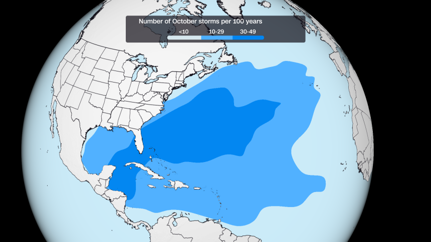
Four named storms — that’s tropical storm strength or greater — typically form in October and November, but some hurricane seasons can have a stronger finish while others quiet down.
The last few years illustrate this year-to-year ebb and flow. Seven storms formed during October and November in 2024, but just two formed during the same time in 2023.
Late-season storms tend to form closer to the United States, including in the Gulf, Caribbean and off the Southeast coast, which makes them more likely to impact land.
While there are usually fewer storms, they can still be destructive.
Last year, Category 5 Hurricane Melissa devastated Jamaica in October’s final week.
Hurricane Michael roared into the Florida Panhandle on October 10, 2018, becoming the latest landfalling Category 5 on record in the US. And Hurricane Sandy may be the most notorious of all: It morphed into a hybrid superstorm in late-October 2012 and walloped the East Coast.
Super El Niño’s grip on the Atlantic basin means a repeat of notorious late-season hurricanes is less likely this year. Its storm-killing wind is the main reason this season could go hurricane-free for the first time in reliable records.