

WLOS — As remnants of Hurricane Isaias moves through the South this weekend, western North Carolina is experiencing wet and windy conditions. The weather has caused disruptions in some areas, including power outages and downed trees.
According to a Duke Energy power outage map update, remnants of Isaias are bringing heavy rain, gusty winds and power outages to some areas in the Carolinas. Their crews are working to assess damage and restore power as safely and quickly as possible. The energy company advises staying away from downed power lines.
Click here for Duke Energy’s map documenting current power outage in the Carolinas.
Officials also advise caution on roadways. The North Canton Fire Department posted on Facebook about a two-car crash on West Interstate 40, mile marker 32.5, saying to exercise extreme caution due to the amount of rain that has fallen and continues.
North Carolina Emergency Management activated Mooresville Fire-Rescue’s Swift Water Rescue team to western North Carolina, with 12 Mooresville Fire-Rescue members deploying to Yancey County.
WESTERN NORTH CAROLINA BRACES FOR POTENTIAL IMPACTS FROM HURRICANE ISAIAS
Flood Watch
According to the National Weather Service, the following western North Carolina counties are under a Flood Watch through Sunday afternoon:
Avery CountyBuncombe CountyBurke CountyCaldwell CountyMcDowell CountyPolk CountyRutherford CountyHaywood CountyHenderson CountyMacon CountyMitchell CountyJackson CountyTransylvania CountyYancey County
The NWS said the impacts could be excessive runoff that could result in flooding of rivers, creeks, streams, and other low-lying and flood-prone locations. Creeks and streams may rise out of their banks. Low-water crossings may flood.
Flash Flood Warning
According to the National Weather Service, the following western North Carolina counties in News 13’s viewer area are under a Flash Flood Warning until 4:15 a.m. Sunday:
Southeastern Buncombe CountyNorthwestern Rutherford County
The following counties are under the Flash Flood Warning until 5:15 a.m.:
Henderson CountyPolk CountyTransylvania County
The following counties are under the Flash Flood Warning until 2 a.m.:
Some areas that may experiences flooding include Town of Lake Lure, Chimney Rock Village and Bat Cave, the weather service adds.
The NWS said potential impacts include nuisance flooding of low-lying areas adjacent to streams and other poor-drainage areas. Isolated, shallow flows over roadways is possible. A few flood-prone, low-water crossings may become impassible. A small culvert washout or two is possible
A High Wind Warning is issued from midnight to 8 a.m. Sunday for our mountains over 3,500′ where wind gusts up to 60 mph are likely.
EMERGENCY SHELTERS OPEN AHEAD OF ISAIAS
Below are various weather-impact updates from western North Carolina counties starting Saturday, Oct. 10:
Buncombe County
There’s Flash Flood Warning for Southeastern Buncombe County until 4:15 a.m.
The Riceville Volunteer Fire Department said they have been dealing with multiple downed trees and broken power poles, with at least two transformers on the ground. RVFD also said Duke Energy crews are spread out in the area to restore power as quickly as possible, but it may be late tonight or even Sunday until repairs are complete.
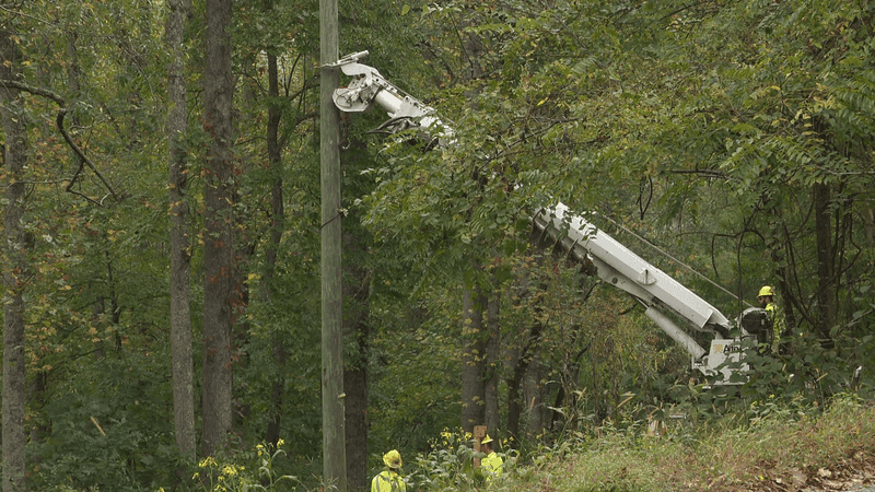
OCT. 10, 2026 – Crews fix a power pole in Riceville, N.C. (Photo credit: WLOS Staff)
Asheville
The Asheville Fire Department’s REST team is going out to unhoused encampments to inform people and advise them to move to safer ground if flooding occurs.
Around 1 p.m., the Asheville Fire Department said Duke Energy was bringing in crews from the coast to stage in Asheville. At 4:48 p.m., AFD said Duke Energy is working as quickly and safely as possible. Hazardous roads may delay travel and restoration until they are cleared. AFD added that Duke Energy technicians don’t do work up in bucket truck when winds reach 30 miles per hour.
News 13 observed crews cleaning up downed tree limbs along Westgate Pkwy today.
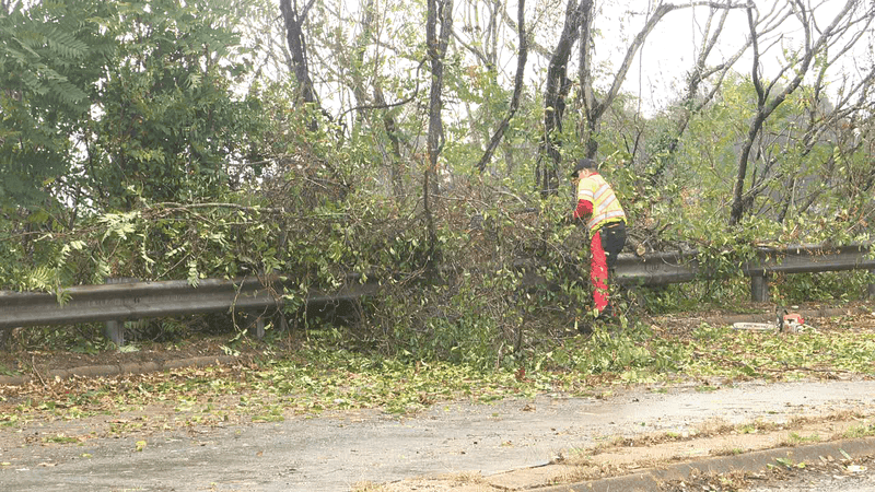
OCT. 10, 2026 – Crews clean up downed tree limbs on Westgate Pkwy in Asheville, N.C. (Photo credit: WLOS Staff)
McDowell County
At 10:25 p.m., McDowell County Emergency Management said the National Weather Service issued a Flash Flood Warning until 4:15 a.m. for the county.
McDowell County is experiencing flash flooding after torrential rainfall added another 1.5 to 2.5 inches of rain on top of 2 to 4 inches recorded over the previous 12 hours, causing streams and tributaries to rise rapidly. Flooding has closed parts of Sugar Hill Road and Lytle Mountain Road, while a landslide has been reported on NC-226A with minor roadway impacts.
Additional minor flooding is expected to develop over the next one to three hours, with potential impacts in Marion, Old Fort, Lake James, Pleasant Gardens, Sugar Hill and Glenwood. Officials are urging residents to obey road barricades and follow any evacuation orders.
At 9:49 p.m., McDowell County fire marshal and Emergency Management deputy director Andrew Pressley said there are confirmed reports of a landslide on NC-226A near the county line. He adds that isolated flooding is happening in the Marion, Sugar Hills and Glenwood areas, affecting low-lying and poor-drainage locations.
At 8:10 p.m., McDowell County Emergency Management issued a Flood Advisory until 2 a.m.
McDowell County officials are warning of possible flooding after 2 to 4 inches of rain fell across the area over the past 12 hours, saturating the ground and causing streams to rise. Mill Creek, Crooked Creek and other tributaries flowing into the Catawba River near Old Fort are among the waterways experiencing rising levels.
Additional showers and thunderstorms are expected through early Sunday morning, increasing the risk of flash flooding and potentially causing flooding to develop or return in affected areas. Communities that could experience flooding include Marion, Old Fort, Lake James, Pleasant Gardens and Glenwood. Residents are urged to use caution near streams, seek higher ground if heavy rain develops and follow evacuation orders from emergency management officials.
At 9:49 p.m., McDowell County fire marshal and Emergency Management deputy director Andrew Pressley said there are confirmed reports of a landslide on NC-226A near the county line. He adds that isolated flooding is happening in the Marion, Sugar Hills and Glenwood areas, affecting low-lying and poor-drainage locations.
Mitchell County
Mitchell County Emergency Management is monitoring Isaias, forecast to affect the county throughout Saturday and into Sunday, Oct. 11.
Mitchell County is under a Flood Watch until 2 p.m. Sunday, with excessive rainfall potentially causing flash flooding and landslides. A High Wind Warning is also in effect until 8 a.m. Sunday, with wind gusts reaching up to 60 mph in areas above 3,500 feet.
County officials are urging residents to secure outdoor items, keep electronic devices charged and have multiple ways to receive emergency alerts. Those in flood-prone areas should be prepared to move to higher ground and avoid driving through flooded roads.
Rutherford County
At 12:08 a.m. on Sunday, Oct. 11, Rutherford County Emergency Management said Lake Lure officials are opening the dam’s tainter gates to three feet, resulting in increased water flow into the Broad River downstream of Lake Lure Dam.
At 10: 15 p.m., Rutherford County Emergency Management activated Flash Flood Warning sirens for the Fall Creek area north of Chimney Rock, N.C.
Residents and visitors near the Rocky Broad River in the Chimney Rock and Lake Lure areas are urged to move away from the river and seek higher ground immediately. Water levels can rise quickly with little warning, so monitor weather conditions and remain alert.
At 8:45 p.m., the county said between three to 4 inches of rain has fallen, causing the Rocky Broad River and nearby streams to rise. Additional rain is expected overnight, so flooding could develop quickly.
3:45 p.m. Town of Lake Lure is monitoring lake levels with the current elevation at 987.8 Mean Sea Level. The town advises residents along the Rocky Broad River, around Lake Lure, and downstream along the Broad River to remain alert for flood sirens and voice messages. If sirens sound, listen carefully for instructions and follow directions from local officials.
According to the National Weather Service: A Flood Watch remains in effect in Rutherford County through Sunday afternoon. The National Weather Service also issued a Flood Advisory for northwestern Rutherford County, including Lake Lure, Chimney Rock and Bat Cave until Sunday.
Henderson County
At 10:30 p.m., the National Weather Service issued a Flash Flood Warning for Northeastern Henderson County until 4:15 a.m.
Henderson County officials are warning of flash flooding along the Rocky Broad River and its tributaries after torrential rainfall added 1 to 2 inches of rain on top of 3 to 4 inches recorded over the previous 12 hours. The river gauge near Bat Cave has exceeded minor flood stage and is expected to continue rising, potentially causing flooding along U.S. 64/74 (Main Street) near Dogwood RV Park in Chimney Rock.
Additional minor flooding is expected to develop over the next one to two hours. Officials are urging residents to obey road barricades and follow any evacuation orders from local emergency management officials.
At 3:59 p.m., Bat Cave Fire and Rescue Department said power lines were down on US 74A between Bat Cave Station and Possum Hollow and the road is closed.
The City of Hendersonville said there’s a Flood Advisory in effect for Henderson County until 7:30 a.m. Sunday.
Henderson County officials are warning of possible flooding as 3 to 4 inches of rain have fallen across the area over the past 12 hours, causing streams to rise and approach bankfull levels. Mud Creek has exceeded its 11.5-foot action stage, with low-lying areas of William H. King Memorial Park beginning to flood and water approaching the lowest elevations of the Oklawaha Greenway.
Additional showers and thunderstorms are expected through the early morning hours Sunday, increasing the risk of flash flooding as saturated ground and swollen streams leave little room for additional rainfall. Residents in Hendersonville, Mills River, Fletcher, Flat Rock and surrounding communities are urged to use caution near streams, seek higher ground if heavy rain develops and follow any evacuation orders from emergency management officials.
Haywood County
At 5:07 p.m., Cruso Fire & Rescue said a river in the area rose three feet and they will continue to monitor the water rise.
Jackson County
Jackson County Office of Emergency Management Director Zeb Holland provided an update on current conditions. He said trees have fallen in the area, including on powerlines and on roads. There were even reports of power lines on fire. Jackson County 911 received a report of a tree falling on a home in the Glenview Community and according to the fire department, damage to the home was minimal.
Holland also said emergency management staff is checking rivers and low-lying roads for flooding and according to his update from around 2 p.m., there were no major concerns, but they will continue to monitor.
Polk County
At 6:45 p.m., Polk County public information officer Kellie Cannon provided an update on the weather conditions. She said the National Weather Service is forecasting four inches to six inches of rain in the county, with some areas getting more than eight inches in the late evening. She adds that landslides become more likely after about five inches of rain in 24 hours.
Cannon says to prepare for possible roadway flooding, landslides, downed trees and power outages. She advises that if you live in a flood-prone area and have an alternative place to stay, to consider relocating this evening.
Cannon recommends reporting non-emergency issues like downed trees of flooded roads to the Polk County Emergency Operation Center at (828) 722-5278. If you lose power, report the outage to your provider. Duke Electric: (800) 769-3766. Rutherford Electric: (800) 521-0920
Transylvania County
At 8:24 p.m., Transylvania County Emergency Services said it’s under a flood advisory until 2:15 a.m. on Sunday.
The county’s emregency services is warning of possible flooding after two to four inches of rain fell across the area over the past 12 hours, saturating the ground and causing streams to rise. Out-of-bank conditions are expected along the Little River, Davidson River and Forks of the Upper French Broad River, with an additional two to four inches of rain forecast.
More showers and thunderstorms are expected through early Sunday morning, increasing the risk of flash flooding. Areas that could experience flooding include Brevard, Rosman, Lake Toxaway, Gorges State Park and DuPont State Forest. Residents are urged to use caution near streams, seek higher ground if heavy rain develops and follow any evacuation orders from emergency management officials.
—
Click here to share your weather photos and videos to News 13’s Chime In.