
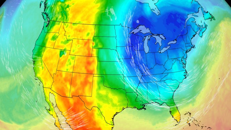
Winter will make its first cameo in the eastern United States later this week as a storm ushers in the coldest temperatures in six months for tens of millions of people and the first snow for some.
🥶 Get your local forecast and track the storm in the CNN Weather app
The nor’easter is set to shake up a period of relative tranquility in the Northeast, becoming the first notable storm since September’s early season nor’easter.
Nearly 200 million people east of the Mississippi will experience their coldest temperatures since spring as a tease of winter plunges south from Canada in the storm’s wake.
The storm will develop across the Midwest Wednesday and slowly strengthen as it pushes east. With it, blustery and sloppy conditions are expected from the Midwest to the Mid-Atlantic and into coastal parts of the Northeast later in the week.
High elevations in the Interior Northeast are likely to see their first snowfall of fall, and the lake-effect snow machine will also power on for the first time since spring in the Great Lakes.
Not every impact is locked in. How much snow and rain will impact the Northeast and New England remains in question with forecast models still disagreeing on the storm’s intensity and speed.
Wet snow is possible in the mountains of the Interior Northeast southward through the central and southern Appalachians, especially by Thursday night and Friday.
Most lower elevations, including the Interstate 95 corridor from Philadelphia to Boston, will just experience a cold rain. Some snow could mix in with rain in the valleys of the Interior Northeast.
Snow totals ranging from a dusting to a few inches could coat the highest elevations of northern New England and Upstate New York. Snow is most likely to stick to the ground in the overnight hours when it’s coldest.
This most likely outcome could change in two ways, depending on the storm’s speed.
A quicker storm would mean less snow that sticks since it would spend less time in the cold air. The impacts would also be over a shorter duration, and most of the rain and any snow would likely be wrapped up by Saturday morning.
On the other hand, a slower storm hugging the coast could allow snow to linger through Saturday. That would give it the potential to drop somewhat higher snow totals.
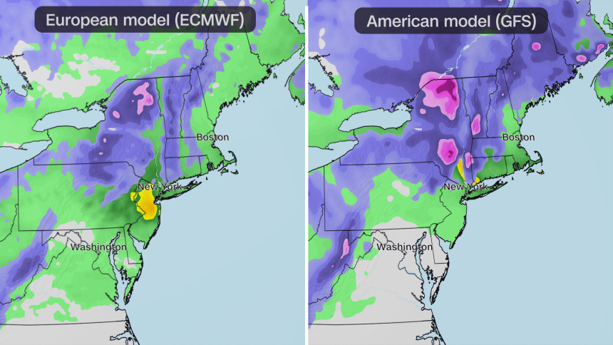
Both storm tracks could generate gusty winds and some coastal flooding in the Northeast but will not be as severe or widespread as they were during September’s nor’easter.
Whether fast, slow or somewhere in between, the storm will bring a dose of soggy weather from the Midwest to parts of the Northeast as well as a blast of cold air from the far eastern Plains to the Atlantic coast.
Behind the storm, a brief cold plunge is set in stone for anyone east of the Mississippi River. Many areas will see their coldest weather since last spring as temperatures drop 5 to 15 degrees Fahrenheit below average.
Sub-freezing temperatures are expected in parts of the Deep South overnight Friday and Saturday.
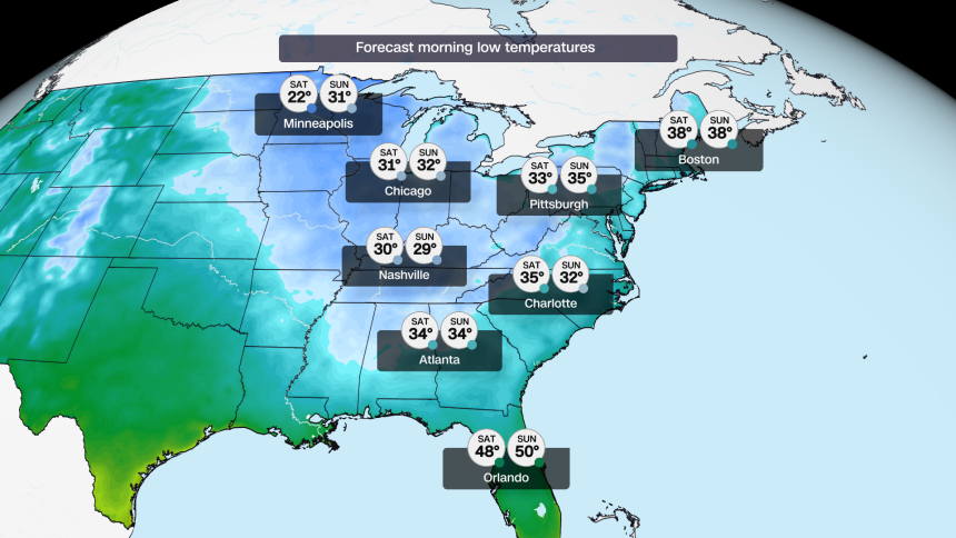
For some in the South, the first freeze may arrive right on schedule as many areas, including Atlanta and Birmingham, Alabama, typically experience it during the first half of November.
Parts of central Florida, like Orlando, could dip into the 40s for the first time since March.
The cold will firmly settle in over the Midwest, from Minnesota to Ohio, preventing temperatures from climbing out of the 40s starting on Thursday and lasting through the weekend.
This cold snap won’t have staying power.
Above-average temperatures are expected to return next week in much of the nation’s eastern half. The mild temperatures could be preview of what’s to come in a winter dominated by Super El Niño.