
The National Hurricane Center on Sunday continued to track newly formed Tropical Storm Fernand in the open Atlantic while also eyeing a system approaching the Caribbean that could become the next tropical depression or storm.
As of the NHC’s 2 p.m. advisory, the center of Fernand was located about 295 miles southeast of Bermuda moving north-northeast at 15 mph with maximum sustained winds of 40 mph. Tropical-storm-force winds extend out 105 miles.
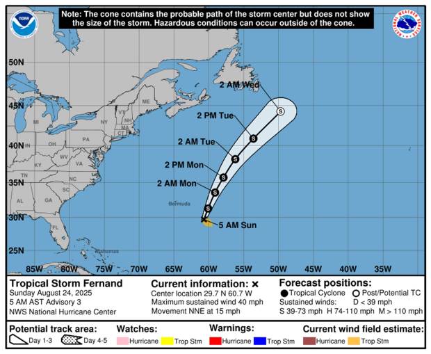 Tropical Storm Fernand’s forecast path as of 5 a.m. Sunday, Aug. 24, 2025. (NHC)
“This motion is expected to continue for the next day or two, followed by a turn to the northeast,” forecasters said. “On the forecast track, Fernand should move well east of Bermuda and across the open waters of the subtropical North Atlantic.”
While it may strengthen in the next two days, it’s not expected to threaten any land before weakening by Tuesday.
Fernand became the sixth named storm of the 2025 Atlantic hurricane season on Saturday while the NHC is keeping track of what could be the seventh farther south in the Atlantic.
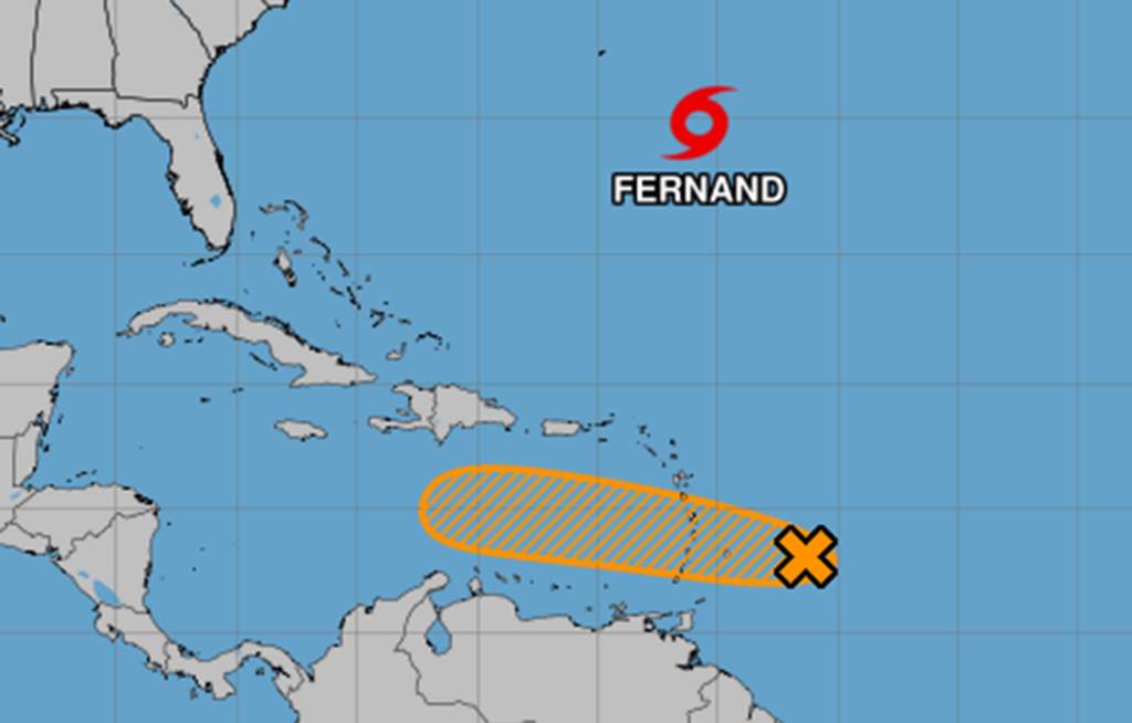
8 pm EDT – NHC is monitoring a tropical wave with a medium chance of development during the next couple of days. This system will likely bring heavy rains and gusty winds to the Leeward and Windward Islands on Sunday and Monday. Visit https://t.co/tW4KeGe9uJ for details. pic.twitter.com/9SZfUgUuiT
— National Hurricane Center (@NHC_Atlantic) August 23, 2025
As of the NHC’s 8 a.m. tropical outlook, the tropical wave was about 200 miles east of the Windward Islands with showers and thunderstorms, but a lack of circulation.
“This system could still become a tropical depression during the next day or two while it moves quickly westward at about 20 to 25 mph, passing through the Windward and Leeward Islands later today and early Monday,” forecasters said.
It could become Tropical Depression Seven or if strong enough be named Tropical Storm Gabrielle.
No matter the development the Caribbean islands can expect heavy rainfall and gusty winds through Monday. It’s then forecast to move into the Central Caribbean on Tuesday where conditions are less favorable for additional development.
An Air Force reconnaissance aircraft is scheduled to investigate the system later Sunday.
The NHC gave it a 40% chance to develop in the next two to seven days.
The National Oceanic and Atmospheric Administration recently updated its season forecast to call for 13-18 named storms this year, of which five to nine would grow into hurricanes. Two to five of those would develop into major hurricanes of Category 3 or higher.
The height of hurricane season runs from mid-August into October while the entire six-month season runs June 1 to Nov. 30.
Originally Published: August 24, 2025 at 6:00 AM EDT