
Discussion on grain size characteristics and sedimentary environment of quaternary stratigraphy
The grain-size characteristics of Quaternary sediments can provide a direct reflection of sediment transport dynamics and depositional environments. Systematic, high-resolution grain-size analysis is an effective tool for interpreting sedimentary processes and genesis5,42,43,44,45. Because of the relatively thin Holocene strata and the limited number of grain-size samples in the Bayan borehole, attributable to its more recent deposition, this section is excluded from further discussion.
The sedimentary interval from 1.50 to 18.80 m in the Bayan borehole is assigned to the Guxiangtun Formation, corresponding to the middle-late Late Pleistocene. The grain-size composition and parameter characteristics are listed in Table 2.. The average proportion of coarse silt (16–63 μm) was 42.47%, representing the dominant modal grain size group, whereas fine silt (4–16 μm) constituted the secondary modal component, with an average content of 31.41%. The Md ranges from 6.26 to 47.30 μm, averaging 22.69 μm, and Mz varies from 7.42 to 65.77 μm, with an average of 28.75 μm. The average standard deviation (σ) is 1.54. Based on the mixed sediment classification scheme46,47, most samples plotted within the silt field on the lithological triangle diagram, with fewer samples classified as clayey silt. The grain-size frequency curves display a single broad peak, a weak secondary peak in the finer fraction, and exhibit negative skewness (Fig. 11).
Table 2 Statistics of grain size composition and parameters of Quaternary strata in the Bayan borehole.Fig. 11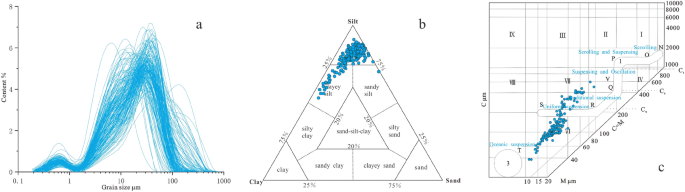
Grain size frequency curves (a), lithologic triangle map (b), and C-M grain-size plot (c) of the Guxiangtun Formation.
The Md of the Guxiangtun Formation is clearly reflected in its grain-size frequency curves, indicating a high-energy transport environment. The average standard deviation of 1.54 suggests poor sorting. The C-M plot positions the samples within the transition from graded suspension to uniform suspension, implying a transport regime capable of carrying coarser grains. The graded suspension deposits are characterized by a proportional increase in both C and M values; as bottom current velocity decreases, uniform suspension transitions into graded suspension, leading to sediment deposition. This pattern is typical of fluvial sediments in modern depositional basins48,49,50,51. Based on the combined analysis of the grain-size parameters and lithological features from the core, the Guxiangtun Formation is interpreted to have formed in a fluvial depositional environment.
The strata from 18.80 to 35.50 m in the Bayan borehole were assigned to the Harbin Formation, with a sedimentary age ranging from the late Middle Pleistocene to the early Late Pleistocene. The grain-size composition and parameter characteristics are listed in Table 2.. The fine silt fraction (4–16 μm) averaged 42.86%, constituting the dominant modal grain size group, whereas the coarse silt fraction (16–63 μm) averaged 41.30%, forming the secondary group. Md was 14.95 μm, and Mz was 18.54 μm. Compared to the Guxiangtun Formation, the Harbin Formation exhibits significantly finer grains, with silt content reaching up to 84.16%, indicative of reduced transport energy and finer sediment sources. Previous studies have demonstrated that the coarse silt fraction constitutes the “aeolian basic grain group”, forming the primary component of typical aeolian loess, while the clay fraction represents the “entrained grain group”, serving as a secondary modal grain size group42. This grain-size distribution reflects the atmospheric background conditions of aeolian loess regions and indicates a sustained process of dust deposition7. Aeolian loess sediments are generally poorly sorted, with suspended grains smaller than 70 μm dominating their composition52. The grain-size composition of the Harbin Formation supports the aeolian deposition theory. The grain-size frequency curve exhibited a broad secondary peak near 1 μm, reflecting the clay fraction linked to atmospheric background processes. The curve demonstrated a bimodal distribution, weak negative skewness, and a relatively sharp primary peak (Fig. 12a). Most grain-size samples fell within the clayey silt category, with occasional occurrences in the sandy clay and sand-silt-clay zones (Fig. 12b). The C-M diagram (Fig. 12c) suggests that the samples were situated in the transitional zone between uniform suspension and pelagic suspension, with a distribution trend parallel to the C = M line. This indicated the predominance of finer grains and a lower transport energy relative to fluvial processes, which is consistent with previous studies7,8,13. These characteristics collectively indicated that the Harbin Formation was deposited in an aeolian environment.
Fig. 12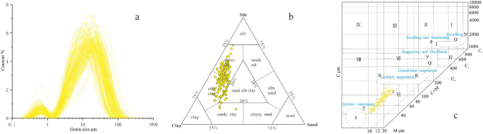
Grain size frequency curves (a), lithologic triangle map (b), and C-M grain-size plot (c) of the Harbin Formation.
The strata from 35.50 to 58.00 m in the Bayan borehole were assigned to the Huangshan Formation, with a sedimentary age corresponding to the mid Middle Pleistocene. The grain-size composition and parameter characteristics are detailed in Table 2.. The very fine silt fraction (4–16 μm) averaged 44.97%, representing the dominant modal grain size group, whereas the coarse silt fraction (16–63 μm) averaged 37.54%, serving as the secondary modal group. The Md ranged from 6.93 to 23.70 μm, with an average of 13.08 μm, and the Mz ranged from 8.16 to 29.77 μm, averaging 17.00 μm. The grain-size frequency curve was characterized by a distinct single peak, a weak secondary peak in the finer fraction, and negative skewness (Fig. 13a), similar to the pattern observed in the Guxiangtun Formation. However, both the median and mean grain sizes were notably finer than those of the Guxiangtun Formation. In the ternary lithology plot, most samples fell within the silty clay domain, with a smaller number located in the sand-silt-clay transitional zone (Fig. 13b). The C-M plot (Fig. 13c) shows that the grain-size samples were distributed in the transitional area between uniform and pelagic suspension, consistently below the CU line. The CU boundary reflected the upper grain-size limit for uniform suspension and represented the maximum hydrodynamic energy just above bottom turbulence49. These results suggested that the Huangshan Formation was deposited under lower-energy conditions, characterized by finer sediments and a relatively calm depositional environment.
Fig. 13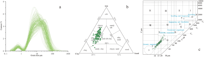
Grain size frequency curves (a), lithologic triangle map (b), and C-M grain-size plot (c) of the Huangshan Formation.
Previous studies have generally identified the Huangshan Formation as a result of fluvio-lacustrine deposition3,7,8,13,53. In the Bayan borehole, the Huangshan Formation is noticeably darker in color than the overlying Harbin and Guxiangtun Formations. It displayed clear bedding structures and a vertical grain-size trend that became coarser downward. The grain size was consistently finer than that of the Guxiangtun Formation. Based on lithological ternary diagrams and C–M plot analyses, the Huangshan Formation was interpreted to represent a shallow lacustrine depositional environment.
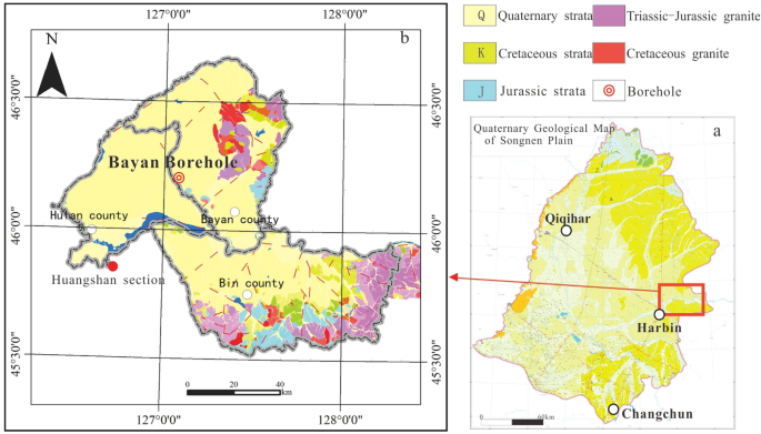
The Bayan borehole is situated on the eastern clayey ridge high plain of Songnen Plain. This region exhibits ridge-like undulations shaped by fluvial erosion and denudation, forming a pediment erosion surface alongside episodes of riverine deposition27. During the Middle Pleistocene, the eastern high plain underwent regional uplift, leading to gradual shrinkage of the ancient Songnen Lake8 and deposition of the Huangshan Formation in a shallow lacustrine setting. In the late Middle Pleistocene, the region experienced relatively stable subsidence, allowing for sustained loess accumulation and the onset of Harbin Formation deposition. During the early to middle stages of the Late Pleistocene, the eastern high plain of the Songnen Plain began to experience uplift, elevating the secondary lacustrine terraces above the water level. Influenced by neotectonic activity, intensified crustal uplift and fluvial downcutting led to the formation of relatively elevated river terraces6,13,15,17. These terraces subsequently underwent river deposition, giving rise to the Guxiangtun Formation.
Indicative significance of grain-size end-member
Loess deposits typically contain fine-grained components derived from three primary sources: (1) direct wind transport and deposition, (2) aggregation-based migration or adherence of fine grains to coarser grains54, and (3) clay-sized fractions (<2 μm) produced by weathering and pedogenesis55. In the Bayan borehole, the EM1 component representing fine silt (modal size: 6.72 μm) was minimal. Grains within the 2–16 μm range can remain suspended at high altitudes and be transported over long distances. Based on previous end-member analyses of Huangshan loess16,31, this grain-size fraction is interpreted as “background dust”56. The EM2 component corresponded to medium silt. Previous studies have shown that grains ranging from 22 to 31 μm can be transported over medium to long distances through suspension57, whereas grains larger than 63 μm typically result from short-range transport and deposition under high-energy wind conditions58,59. The correlation coefficient between EM2 and the >63 μm grain-size fraction was −0.47 (Table 3.), indicating a negative relationship and suggesting that EM2 was not derived from proximal transport. The EM2 modal value was slightly lower but comparable to that of the Huangshan Loess (27.20 μm), and it is regarded as a proxy for southeast wind intensity16,31. The Northeast Asian low, centered over the central and eastern Mongolian Plateau, causes low-level westerlies and the mid-latitude EASM to converge in this region, generating strong and frequent southwesterly winds60,61,62. These winds transport aeolian dust from the OD, HQ, and southwestern SN regions to downwind areas, thus forming Harbin loess deposits31. Accordingly, EM2 can serve as a proxy indicator of the southwesterly wind intensity in this region. The EM3 component falling within the coarse silt fraction was finer than the EM3 identified in desert loess deposits (54.41 μm). It is positively correlated with both Mz (mean grain size) and the >63 μm fraction (r = 0.86 and 0.88, respectively), indicating a near-source origin. Its sharp peak and well-sorted grain-size curve reflected the limited transport distance and height. According to Prins et al.63, because components >40 μm are typically linked to near-source suspension or saltation under strong winter monsoon forcing, EM3 was interpreted as a proxy for winter monsoon strength in the Bayan region.
Table 3 Correlation analysis of end-member components, Mz, and >63 μm components in the Bayan borehole.Paleoclimatic evolution of the eastern songnen plain since the middle pleistocene
By integrating the comparative curves of magnetic susceptibility, mean grain size, grain-size end-members, and marine oxygen isotope records (Fig. 14), this study investigated climate and environmental changes in the eastern Songnen Plain from the Middle Pleistocene. During this period, magnetic susceptibility values were generally low, mostly below 10×10−8 m3/kg. Previous studies on the Songnen Plain have demonstrated that magnetic susceptibility tends to increase during dry and cold periods and decrease during wet and warm intervals13,31,64,65. Prior to ~250 ka, the EM3 content exhibited a fluctuating trend, indicating progressive intensification of the East Asian winter monsoon and a shift toward colder and drier climatic conditions in the Harbin region. Conversely, EM2 displayed an opposing trend, with generally low values, reflecting a weaker summer monsoon. These patterns are consistent with regional paleoclimatic reconstructions16,31. Thus, the mid-Middle Pleistocene climate in the eastern Songnen Plain was marked by a strengthening winter monsoon and weakening summer monsoon, indicative of a predominantly cold and arid environment. The variations in the end-member components, Mz, and magnetic susceptibility were closely aligned with glacial-interglacial cycles. During glacial periods, intensified winter monsoons led to elevated EM3 content, while interglacial periods saw increased EM2 levels, highlighting the role of global ice volume as a primary control on regional monsoonal dynamics16. Notably, at approximately 45 m depth, corresponding to the MIS9 stage, a marked increase in magnetic susceptibility was observed. At this level, curve changes of grain size end-members were highly coupled with Mz. The EM2 component increased sharply, the EM3 component significantly decreased, and the mean grain size also increased. This coupled signal reflects a significant glacial-interglacial transition event during the mid-Middle Pleistocene.
Fig. 14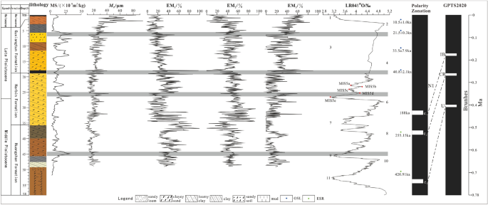
Comprehensive comparison of grain-size end-members, magnetic susceptibility, MZ and LR04δ18O66 of the Bayan Borehole.
After approximately 250 ka, the regional climatic environment of the eastern Songnen Plain underwent a marked transition. The fine-grained EM2 component exhibited a significant increasing trend, whereas EM3 remained consistently low, with only minor increases. The combined variation patterns of EM2 and EM3, along with generally low magnetic susceptibility values, suggested a gradual intensification of the summer monsoon and a shift toward a cooler and more humid climate between 250 ka and 129 ka. Unlike earlier periods, the variations in grain-size end-members and Mz, as well as magnetic susceptibility, show weaker coupling with glacial-interglacial cycles. This decoupling may be attributed to fluctuations in high-latitude solar radiation, which are known to influence regional climate patterns and monsoon intensities16,31. These solar-driven changes have altered the dust source dynamics, contributing to the contraction of the Songnen Sandy Land15 and reducing the supply of locally derived coarse grains. This observation is consistent with sedimentological evidence, as the grain size parameters (Mz, Md, and C-M plot) of the Wangkui and Bayan boreholes are generally smaller than those of the Huangshan section15 (Fig. 8).
At the Middle-Late Pleistocene boundary (26.10 m), the Bayan borehole recorded a pronounced increase in magnetic susceptibility, accompanied by a sharp rise in Mz, a significant decline in the EM2 component, and a notable increase in EM3. These changes corresponded to the MIS5d-MIS5e transition, suggesting a brief climatic shift in the eastern Songnen Plain characterized by a weakening summer monsoon and a strengthening winter monsoon, leading to drier and colder conditions. This phase lasted for approximately 14 ka. Subsequently, the magnetic susceptibility values decreased and stabilized at low levels, while the EM2 values continued to rise and remained elevated, which was indicative of a sustained warm and humid climate20 and consistent with the last interglacial period of the Late Pleistocene67. The black clay layer at 17.8–18.8 m was rich in organic matter and contains well-developed iron–manganese concretions, typically formed under alternating dry-wet and freeze-thaw cycles68. Despite a marked decline in magnetic susceptibility, the EM2 and EM3 components during this interval exhibited contrasting signals: a weakened summer monsoon and a strengthened winter monsoon. This discrepancy may reflect the overriding influence of high-latitude solar insolation during this period69,70,71, suggesting that the eastern Songnen Plain experienced a brief warm-humid interlude within the Last Glacial Period.
During the Last Glacial Period, beginning around 41 ka, notable shifts occurred in the trends of the grain-size end-members, Mz values, and magnetic susceptibility curves. These variations aligned with the global climatic patterns of the Last Glacial Period, particularly in high-latitude regions that experienced progressive cooling, declining sea levels, reduced precipitation, and increased aridity72,73,74. The eastern Songnen Plain is situated within the cold-temperate to sub-frigid climatic zone, with mean annual temperatures estimated to be over 6 °C lower than present-day values67. Magnetic susceptibility increased significantly during this period, exhibiting cyclical fluctuations. The EM2 component remained at moderate to low levels, with frequent variability, whereas EM3 showed an opposite trend, oscillating upward, indicating strengthening of the winter monsoon. These results suggested that the eastern Songnen Plain underwent climatic progression from cold and dry to cool semi-humid conditions before reverting to cold and dry conditions during the Late Pleistocene.
With the onset of the Holocene Climatic Optimum, regional temperatures increased, precipitation levels rose, and sea levels began to increase. As a result, the eastern Songnen Plain shifted into a mid-temperate zone, characterized by a warm, semi-humid climate. These favorable environmental conditions promote extensive pedogenesis, leading to the widespread development of fertile black soils.