
If you have anything to do outdoors this weekend, Saturday morning is your best bet.
After that, all bets are off, as Mother Nature will deliver rain, wind, and then a round of lake effect snow across much of the Western New York region.
Rain will develop quickly from west to east this afternoon, before tapering off this evening. Gusty winds will develop tonight and last through Sunday. Lake effect snow showers develop southeast of the lakes Sunday and linger through Monday night. pic.twitter.com/HoGWlKMZlc
— NWS Buffalo (@NWSBUFFALO) November 15, 2025
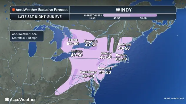
Temperatures will rise to around 10 degrees above normal Saturday, ahead of the next storm system that will bring a period of rain Saturday afternoon and Saturday night, National Weather Service forecasters say.
Behind a cold front Sunday, rain showers will change over to snow, with a little lake effect snow southeast of the Lakes Sunday night.
After rain showers overspread the area Saturday afternoon, gusty winds will approach late Saturday into Sunday, with gusts to 35 mph at times, and even higher gusts along the lakeshore.
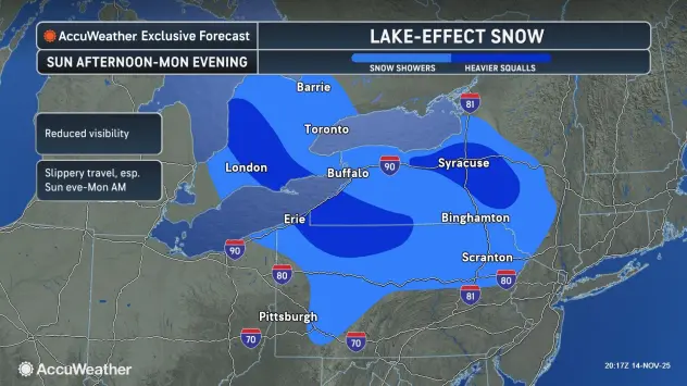
Photo credit AccuWeather.com
Winds across the lake will also develop some lake effect rain and snow showers late Saturday and early Sunday, however any minimal accumulations will be confined to the higher elevations of the southern tier.
Colder air will support lake effect snow showers during the Sunday afternoon hours, mainly well south of the Buffalo metro area. Late Sunday and into early Monday, at least a few inches of snow will be possible southeast of the lakes, but uncertainty still remains as current guidance does have the lake bands moving some through Sunday night and into Monday morning. The greatest snow amounts can be expected over the higher terrain south of Buffalo.
Stay tuned.
Featured Image Photo Credit: AccuWeather.com