
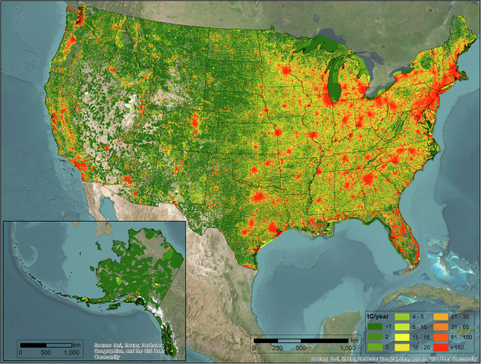
The study domain is the United States, the fourth-largest country in the world (covering approximately 9.8 million square kilometers) with a population of over 333 million people as of 2022. The FFCO2 emission estimates presented here are Scope 1 (i.e., territorial) only and cover 49 states (Hawaii is available in non-gridded form upon request) and the District of Columbia but do not include the U.S. territories (e.g., Puerto Rico). The geographic resolution of the data is 1 km × 1 km and the study period covers the years 2010 to 2022. These have also been aggregated to the county and state scale. The FFCO2 emissions presented also include sub-categorization by sector (electricity production, industrial, commercial, residential, airport, nonroad, onroad, railroad, commercial marine vessels, and cement production) and fuel type (coal, petroleum, and natural gas). Cement production includes both the emissions due to the combustion of fossil fuels and the stochiometric release of CO2 during calcining.
As an update to the Vulcan version 3.0 FFCO2 emissions data product, much of the methodological details of Vulcan version 4.0 are consistent with the methods for Vulcan version 3.0. Here, we primarily notate methodological changes and updates to version 4.0 while succinctly summarizing the Vulcan methodology of the previous version 3.0 for completeness and clarity. For the greatest amount of detail on the methods followed by Vulcan version 3.0, the reader is referred to13,14. We describe the methods following the sector and/or data type description accompanying the input data. The data types refer to the geographic representation of the emissions data: point or nonpoint, while the sectors refer to the commonly categorized economic sectors: electricity production, commercial, industrial, residential, onroad, airport, railroad, nonroad, commercial marine vessels, and cement production.
Nonpoint (i.e., area) source emissions are stationary sources of FFCO2 emissions that are not inventoried or specified at the individual facility, building, or release point scale and can be thought of as representing dispersed sources within a geographic area. These are primarily building emissions, onroad emissions, railroad emissions, and emissions from commercial marine vessels. Point source emissions, by contrast, represent FFCO2 emissions explicitly linked to a stationary release point (i.e., a physically identifiable emission “stack”) or emitting facility. These emissions include emission stacks on buildings (in the electricity production, commercial, cement, and industrial sectors), airports (the aircraft emitting component), and a small amount of railroad and nonroad (defined later).
The sector definitions generally follow commonly used application in GHG emissions quantification but a few warrant additional clarity. For example, the electricity production sector includes facilities that produce electricity and are connected to an electrical grid system. Furthermore, like all the sources included in Vulcan v4.0, they only reflect the combustion of fossil fuels. Power production based on non-CO2 emitters such as renewable sources are not included. The nonroad sector includes all mobile fossil fuel combustion devices that are not considered legal for use on roadways. These include traditional off-road vehicles plus devices such as lawnmowers in addition to waterborne vehicles aside from commercial marine vessels, which are separately managed in the commercial marine vessels sector. Airport emissions include all aircraft emissions during the taxi, takeoff, and landing cycles up to 3000 feet. Baggage carriers and other mobile airport equipment are included in the nonroad sector. Airport buildings are included in the commercial sector. Cement production includes both the FFCO2 emissions resulting from the combustion of fossil fuels and the stoichiometric release of CO2 during the calcining process. The latter is the only non-fossil source in Vulcan and is included because of the common norm of doing so and the magnitude of this process which, among the “process” emissions in the U.S., is the largest.
Some sectors will reflect input data of both point and nonpoint data types while others will reflect input data of only one data type. For example, the industrial sector contains input data of both point and nonpoint while the residential sector only contains nonpoint source reporting data.
Table 1 provides an overview of the data sources used in generating Vulcan version 4.0 FFCO2 emissions including data used to further downscale or condition the data in space and time. Data changes/updates in Vulcan version 4.0 are noted separately.
Table 1 Overview of data sources used in generating the space/time-resolved Vulcan v4.0 FFCO2 emissions (footnotes provide acronym explanations).Electricity production
Vulcan electricity production FFCO2 emissions represent 13,814 grid-connected power generation facilities in 2022. These have been published as a pointwise data product: Vulcan-power version v1.017. In short, these emissions are built from three data sources: the Environmental Protection Agency’s Clean Air Markets Program Data (CAMPD) (Carbon Pollution Emission Guidelines for Existing Stationary Sources 2015; https://campd.epa.gov)18, the Department of Energy’s Energy Information Administration (EIA) EIA-923 survey data (https://www.eia.gov/electricity/data/eia923/index.php), and the United States Environmental Protection Agency’s 2014 and 2017 National Emissions Inventories (NEI)19,20,21,22. Though the CAMPD data set does not include all power plants in the United States, it accounts for 91.6% of the U.S. electricity production FFCO2 emissions in 2022. It reports CO2 emissions based on direct monitoring in the effluent stack. The EIA-923 reporting includes the heat input value (e.g., British thermal units) for each U.S. electricity production facility exceeding a nameplate capacity of 1 MW. FFCO2 emission factors are then utilized to calculate the quantity of FFCO2 emitted from these EIA-923 facilities23. After the removal of the overlap with the CAMPD facilities (keeping the CAMPD facilities), these EIA facilities account for 7.7% of the FFCO2 emissions in the electricity production sector beyond that reported by CAMPD. The NEI reports carbon monoxide (CO) emissions from smaller electricity production facilities and these are processed to FFCO2 emissions using CO and CO2 emission factors gathered from extensive literature review (see Table 2 and13. Further detail on processing of the NEI-based facilities (for other sectors) is discussed below.
Table 2 Heat value, carbon monoxide (CO) emission factor (EF), and carbon dioxide (CO2) emission factor for Vulcan version 4.0 emission sources.
A hierarchy was employed given that there was overlap between the three datasets. This was performed at the unit level given that a single facility might have individual power units reporting to, for example, CAMPD and another only reporting to the EIA. Where overlap did exist at this scale, preference was made to retain the CAMPD data, then the EIA, and finally the NEI. The choice of using the CAMPD emissions reporting over the EIA reporting is detailed in23 and is primarily motivated by analysis indicating that the direct stack monitoring is more accurate than the estimation from fuel inputs.
Point sources
The point emissions represent facilities reported in the 2014 and 2017 NEI with a physically identifiable emission stack or point location and exceed a specific criteria air pollution threshold19. Vulcan version 4.0 follows the same approach as that taken in Vulcan version 3.0. However, the core input data from the NEI now utilizes the 2014 and 2017 NEI releases as opposed to the 2011 NEI release used in Vulcan version 3.021,24. The point processing includes sources classified as industrial, commercial, airport, railroad, and nonroad emitters. Airport, railroad, and nonroad are discussed separately below as they require additional processing beyond that described in this section. Hence, we describe the point processing in the industrial and commercial sectors here.
Vulcan reports FFCO2 emissions for 50720 and 51284 individual facilities in 2014 and 2017, respectively. A number of key fields define a point location for the purposes of the Vulcan point FFCO2 emissions estimation and include the state and county FIPS code, the“state facility identifier” (which identifies the individual emitting facility), and the tribal code (used in place of the FIPS in tribal lands). Each site or facility can have multiple emission points (different“stacks”), emission units (different buildings or portions of a complex facility or site), or emission processes (e.g., energy production, heaters, engines). Some of these have different geocoded locations and these are retained in the Vulcan processing. These were not systematically inspected for location accuracy except in urban domains associated with the Hestia Project: the Los Angeles Megacity, the NE Corridor, Salt Lake City, and Indianapolis25,26,27,28,29.
Each point emission record from the 2014 and 2017 NEI contains a source classification code (SCC), a numerical sequence that identifies characteristics of the emitting entity including sector, fuel, and combustion technology30. Most importantly, each record reports the amount of CO emissions. Both (SCC and CO amounts) are essential to the retrieval of appropriate CO and CO2 emission factors (EFs) used to transform the CO emissions into CO2 emissions. Fossil fuel CO2 emissions are created from the facility CO reporting through the application of CO and CO2 emission factors, as follows:
$${E}_{n,f}^{{{CO}}_{2}}=\frac{{E}_{n,f}^{{CO}}}{{{EF}}_{n,f}^{{CO}}}{{EF}}_{n,f}^{{{CO}}_{2}}$$
(1)
where \({E}_{n,f}^{{{CO}}_{2}}\), are the CO2 emissions for a process n (e.g. industrial 10 MMBTU boiler, industrial gasoline reciprocating turbine) and fuel f (e.g. natural gas, bituminous coal); \({E}_{n,f}^{{CO}}\) are the equivalent amount of CO emissions for a process n and fuel f; \({{EF}}_{n,f}^{{CO}}\) is the CO emission factor for a process n and fuel f; and \({{EF}}_{n,f}^{{{CO}}_{2}}\) is the CO2 EF for a process n and fuel f.
The point source emitting process is matched to a CO EF via the SCC from the U.S. EPA WebFIRE EF database as the first choice for the CO EF (https://cfpub.epa.gov/webfire/). Where no match is found, default CO EF values are used, themselves archived from literature review (see Table 2) and determined through a combination of the sector and fuel.
The use of two different NEI reporting cycles required some temporal harmonization. As with Vulcan version 3.0, the complete 2010–2022 time series is constructed by state/sector/fuel scaling supplied by the EIA State Energy Data System (SEDS)31. This multiyear scaling is to either the anchor data year of 2014 (for years 2010-2013, 2015) or the anchor data year 2017 (years 2016, 2018–2022). However, inspection of the complete time series made clear that the two NEI reporting cycles were likely not internally consistent and showed suspicious emission changes between 2014 and 2017 at many individual point facilities in the complete point multiyear results. It is not possible to trace the source of these unlikely changes in emissions between the NEI reporting cycles. A time series smoothing approach was employed to reduce this temporal inconsistency. An adjustment factor is created for the 2010 to 2015 time period and the 2016 to 2022 (or current end year) time period at the facility scale. This is done by differencing the 2014 and 2017 values for each facility record common between the two years and comparing that to the mean of the first and second time period standardized variances (the “background” variance). If the jump (expressed as a standardized variance) exceeds the background variance, 1/2 the absolute exceedance is added/subtracted from the respective years (2014, 2017) to moderate the jump. If the jump standardized variance does not exceed the background variance or either year has a zero value, no action is taken. The choice to avoid this scaling when one or the other year has zero emissions at a common facility is to allow instances where there is a cessation of activity at a facility (i.e., out of business or economic downturn). Given the impact this can have on the two anchor reporting years, multiyear scaling with the SEDS data is repeated after this adjustment to the complete time series.
The point industrial sector FFCO2 emissions in the year 2014 are decreased by 7.38% while the point industrial FFCO2 emissions in 2017 are increased by 9.2% as a result of this adjustment. The number of individual industrial facilities impacted by the adjustment was 41.5% of the total point industrial facilities, indicating that these were smaller emitters exhibiting the relatively sudden changes in emissions between the two NEI reporting years. In the commercial sector the equivalent changes are −8.99%/ +12.6% which impacted 42.9% of facilities. In the electricity production sector, the equivalent changes are −7.2%/ +8.9% impacting 25.3% of facilities. However, given that the NEI-based electricity production only accounts for 1.1% of the electricity production FFCO2 emissions total, these changes remain very small in context.
Further development is made in Vulcan version 4.0 by incorporating facility emissions reported to the electricity production sector in the EIA data noted in the previous section but for which the sole source consumer is either a commercial or industrial entity. These are identified as such in the EIA electricity production reporting and categorized as either commercial or industrial emission sources as appropriate and include as such.
Additional updates have been made to the CO and CO2 emission factors used in processing the point source CO emissions from the NEI reporting. The values used in point and nonpoint (next section) processing are shown in Table 2.
Nonpoint
Nonpoint emissions as reported in the 2014 and 2017 NEI encompass diffuse sources of emissions that are not reported via the point reporting or via reporting for onroad emissions20,22. Nonpoint emissions contribute to, or fully constitute, emissions in the residential, commercial, industrial, nonroad, railroad, and commercial marine vessels (CMV) sectors used in Vulcan. As with the point source emissions methodology, the procedures are consistent with those described in the Vulcan version 3.0 data product with some exceptions. As with point emissions, the core input data from the NEI now utilizes the 2014 and 2017 NEI releases as opposed to the 2011 NEI release used in Vulcan version 3.0.
The use of two different NEI reporting cycles required temporal harmonization in much the same way as performed in the point source data processing. The complete 2010-2022 time series is constructed by state/sector/fuel type scaling supplied by the EIA SEDS data. This multiyear scaling is to either the data year of 2014 (for years 2010-2013, 2015) or the data year 2017 (years 2016, 2018-2022). Similar jumps noted in the point data were evident in the nonpoint reporting albeit for spatial units of counties as opposed to facilities. A time series smoothing approach was employed to reduce this temporal inconsistency. An adjustment factor is created for the 2010 to 2015 time period and the 2016 to 2022 (or current end year) time period at the sector/county/fuel type scale. This is done by differencing the 2014 and 2017 values for each sector/county/fuel type record common between the two years and comparing that to the mean of the first and second time period standardized variances (the “background” variance). If the jump (expressed as a standardized variance) exceeds the background variance, 1/2 the absolute exceedance is added/subtracted from the respective years (2014, 2017) to moderate the jump. If the jump standardized variance does not exceed the background variance or either year has a zero value, no action is taken. Given the impact this can have on the two anchor reporting years, multiyear scaling with the SEDS data is repeated after this adjustment to the complete time series.
The changes in the 2014 and 2017 emission magnitudes were smaller than needed in the point source data. Here, the nonpoint industrial sector FFCO2 emissions in the year 2014 are decreased by 1.04% while the nonpoint industrial FFCO2 emissions in 2017 are increased by 0.8% as a result of this adjustment. The number of individual industrial county/fuel combinations impacted by the adjustment was 25.4% of the total nonpoint industrial county/fuel combinations, indicating that these were small emitting counties exhibiting the relatively sudden changes in emissions between the two NEI reporting years. In the commercial sector the equivalent changes are −3.3%/ +2.9% which impacted 26.7% of county/fuel combinations. In the residential sector, the equivalent changes are +3.0%/−2.8% impacting 43.6% of the county/fuel combinations. In the railroad sector the equivalent changes are −1.1%/ +1.1% impacting 31.6% of the county/fuel combinations.
An initial comparison of state/sector/fuel type sums of the nonpoint and point equivalent fuel consumption was made to the EIA SEDS fuel consumption data in the NEI years: 2014 and 2017. The aim was to adjust the state/sector/fuel type totals to match the EIA SEDS state/sector fuel type total consumption values. However, prior to scaling the NEI totals to the EIA SEDS totals, it was noted that there were individual county and whole state gaps for a few combinations of specific fuel types, sectors and county/states. Each of these missing instances is individually examined and gap-filled if there is evidence that fuel consumption was likely to have occurred. This included inspection such as, the presence of housing, natural gas infrastructure, fuel in one sector but missing in another (e.g., commercial natural gas in a county with adjacent residential buildings but missing residential natural gas), or LPG consumption (indicating limited pipeline natural gas). The gap-filled amounts were further debited from the EIA SEDS state/sector/fuel type totals.
After the gap-filling procedure was completed, adjustment to match the revised EIA SEDS state/sector/fuel type totals was made. As noted previously, this adjustment operation takes into account the summation of both the point and nonpoint Vulcan CO2 emissions defined at the state spatial scale and for fuel type (coal, petroleum, natural gas) and sector (residential, commercial, industrial). This is due to the fact that EIA SEDS has no point-nonpoint distinction but reflects a total (point + nonpoint) for a sector/fuel combination.
Adjustments to the Vulcan point + nonpoint state/sector/fuel totals are made to the nonpoint residential, commercial and industrial state totals for natural gas and petroleum fuel (aggregate) only. No adjustments are made to coal consumption in the residential and commercial sectors as it is established that coal emissions are small to non-existent in these sectors.
The sector total for the point and nonpoint are compared to the equivalent EIA SEDS value and the difference used to adjust the nonpoint total as needed to match the EIA SEDS totals and the Vulcan totals at the state/sector/fuel type scale. A negative difference (Vulcan larger) requires an adjustment factor < 1: {1 + (Δ/Vulcan nonpoint)} where Δ is the difference between the EIA value and the sum of the Vulcan point + nonpoint. A positive difference (Vulcan smaller) requires an adjustment factor > 1: {1-(Δ/Vulcan nonpoint).
With the further adjustment to the NEI base year CO2 emission amounts, it is necessary to perform the multiyear scaling again.
The Vulcan version 4.0 increases the resolution of the subcounty distribution for the nonpoint residential, commercial, and industrial FFCO2 emissions from that of U.S. Census block-groups to U.S. Census blocks. U.S. Census blocks are defined as the smallest geographic unit for which the U.S. Census Bureau collects and tabulates demographic data. They vary in size depending upon the population density but in a typical city they are similar to a city block bounded by roaways on all sides. A U.S. Census block-group is a larger unit, often composed of a cluster of blocks, again varying in size across the U.S. landscape.
The sub-county FFCO2 emissions distribution procedure follows the approach taken in Vulcan version 3.0 with some differences in input data. The downscaling uses the product of total building floor area (specific to a building class) within each U.S. Census block and an estimate of energy use intensity (EUI) specific to fuel type/census division/climate zone/building type.
As in Vulcan version 3.0, the fuel-specific EUI values are calculated from the EIA residential, commercial, and industrial building energy consumption surveys. In Vulcan version 4.0, updates to the survey input data are made. For example, three survey microdata data sets are used for the residential sector32,33,34,35,36,37,38. For the commercial sector, the same vintage survey data was used as was used in Vulcan version 3.039,40. National industrial EUI values were updated to use the microdata surveyed for 201441,42. In all three sectors the energy summed consumption by fuel type/building type/census division/climate zone is divided by the linked summed floor area for that same fuel type/building type/census division/climate zone to arrive at a mean EUI value.
In linking the Federal Emergency Management Agency (FEMA) building types (see next section) to the Residential Energy Consumption Survey (RECS)/ Commercial Buildings Energy Consumption Survey (CBECS)/Manufacturing Energy Consumption Survey (MECS) building types there was a recognition that in some cases the FEMA definition subsumes or includes multiple RECS/CBECS/MECS building types. Hence, new combination building types were created to best represent these combined instances. These new estimates of EUI based on the combinations can then be used in the downscaling calculation. These are shown in Table 3.
Table 3 Crosswalk table for the FEMA to CBECS/RECS/MECS building typology.
The aim is to have an EUI value for every combination of data source (CBECS/RECS/MECS), building type, census division, and climate zone. While most were filled with the EIA survey data, some cannot be calculated due to missing data and hence, a gap-filling procedure is deployed. For missing EUI values in the CBECS or RECS microdata, an average is created that is specific to the data source (CBECS or RECS)/building type/fuel type thereby averaging over census divisions (a national mean value). For MECS, we use a much simpler average (since there is no census division or climate zone distinction) and create a national average specific to fuel type only.
Prior to downscaling to U.S. Census blocks, data from the American Community Survey (ACS) on the number of households in a U.S. Census block-group using a specific fuel type (e.g., coal, petroleum, Natural Gas) is deployed43. This allows for correct fuel type share allocation to the block-group scale (highest resolution available) for the residential sector only, which is then further downscaled to the census block scale. The ACS data is acquired for the pre- and post-2020 census as the block-group ID codes and many block-group shapes changed at the 2020 U.S. Census.
The input data for the total floor area (TFA) at the scale of a U.S. Census block remains sourced from the HAZUS General Building Stock data44. The floor area data are obtained from FEMA HAZUS v5.1 and HAZUS v6.0 data (v5.1 is based on the 2010 U.S. Census; v6.0 is based on the 2020 U.S. Census) at the U.S. census block resolution. Years 2010-2019 use the 2010 census block boundary defnitions while years 2020-2022 use the 2020 census block boundary defnitions (the floor area data was available only for the two Census years). The floor area for all the intermediate years (2011–2019) were linearly interpolated at the block scale. The 2020 TFA was used for the years 2021 and 2022.
Onroad
Vulcan version 4.0 onroad FFCO2 emissions start with information from the 2014 and 2017 National Emissions Inventory (NEI) instead of the Vulcan version 3.0 2011 NEI. The NEI estimates, in turn, are derived from updated simulations using the Motor Vehicle Emissions Simulator model versions MOVES2014a and MOVES2014b for 2014 and 2017 respectively across all counties except the state of California45. The NEI quantifies onroad emissions by U.S. county, distinguishing 13 distinct vehicle types (which include various vehicle classes and fuel types) and five road types (including parking), as well as differentiating between urban and rural roads. These simulations rely on a County Database (CDB) compiled from submissions by State, Local, and Tribal (SLT) agencies. The CDB contains important inputs to the model emissions estimation, such as vehicular registrations, fleet characteristics, age, average speed, and fuel properties. The 2014 NEI features 526 CDB submissions, while the 2017 NEI includes 1,693 CDB submissions out of a possible 3,234 counties19,21,24,46. To generate results for every county, the US EPA utilized various data and modeling tools to complete the CDB for each county in the U.S. California is unique because its onroad emissions submission was used directly in both NEIs, employing its own emissions model, EMFAC (EMission FACtors)47.
The NEI categorizes CO2 emissions according to two road classes: restricted (with guard rails) and unrestricted. The Highway Performance Monitoring System (HPMS), which provides Vulcan with traffic volume data and contributes to the road network basemap, identifies seven road classes (Interstates, Other Freeways & Expressways, Principal Arterials, Minor Arterials, Major Collectors, Minor Collectors and Local Roads). In order to increase the number of observed traffic volume locations for a given road class, these seven road classes were combined into four, i.e., Interstates and Other Freeways & Expressways were combined into interstates, Principal Arterials and Minor Arterials were combined into arterials, Major Collectors and Minor Collectors were combined into collectors while Local Roads remained unmodified48. In order to distribute the FFCO2 emissions from the road classification with four types to the NEI’s two class road classification, data on the state-scale distribution of vehicle miles travelled (VMT) was used48. FFCO2 emissions from the NEI restricted road class were allocated entirely to interstates while the emissions from the NEI unrestricted road class were allocated to arterials, collectors and local roads using the fraction of the respective state’s total non-interstate/freeway VMT on each of these road classes.
To estimate emissions for years other than 2014 and 2017, the approach used for the point and nonpoint multiyear scaling is followed. In this case the EIA SEDS data reflected consumption for the entire ground transportation sector (sum of onroad, nonroad, and railroad) consuming gasoline, distillate (diesel), and natural gas. As with the point and nonpoint processing, scaling across two base years causes a recognizable jump in CO2 emissions across 2015 to 2016 time period. The correction across this time period is employed as was described in the nonpoint processing. Relative multiyear scaling was performed after the jump correction was applied and further scaling was deployed to the U.S. total gasoline and diesel sales figures49,50.
FFCO2 emissions at the county scale are downscaled to road segments prior to aggregation to the 1 km × 1 km gridcells. The road basemap used in Vulcan version 4.0 is an update to the basemap used in Vulcan version 3.0. Vulcan version 4.0 generates a road basemap by integrating the HPMS and Open Street Map (OSM) road networks51,52. This was done since the HPMS road network does not encompass all road surfaces and many small and local roads were more thoroughly represented in the OSM road network, a crowd-sourced, open-source database that has proven comprehensive and accurate for road locations53,54,55. OSM was filtered to exclude non-motorable roads before merging the two road networks. Given the differing descriptions of road classes, HPMS and OSM were linked using the descriptions provided in both datasets’ documentation. A merged basemap was created by geometrically joining the HPMS and OSM road segments, ensuring that there are no overlapping road segments (so no double counting of road segments) from the two sources. FFCO2 emissions associated with parking locations (e.g., truck stops, rest areas) was explicitly included in Vulcan version 4.0. These emisssions were provided as CO2 values and provided as a separate data file in the NEI release for 2014 and 2017, specific to location.
The HPMS data also includes Annual Average Daily Traffic (AADT) data and features seven road classes and an urban/rural classification. Although HPMS data spans multiple years, only the 2015 data was used, which contains the most data points and, therefore, requires the least gap-filling.
For the case of non-local roads, county-scale FFCO2 emissions are allocated to non-local road segments based on the relative share of Vehicular Miles Travelled (VMT). This is calculated as follows:
$${\rm{VMT}}({\rm{i}})={\rm{AADT}}({\rm{i}})\ast {\rm{L}}({\rm{i}})$$
(2)
where AADT is the traffic volume (vehicles/day) on road segment i, and L is the ith road segment length (miles/segment). Then, the share of VMT on each road segment is used to apportion the county-scale total for the non-local road class.
Since the AADT data is only provided for HPMS-defined road segments, AADT for those road segments defined by the OSM road basemap is gap-filled from the HPMS-defined AADT data using the nearest neighbor approach within the same road class category. Because local roads have very limited traffic volume data, FFCO2 emissions are downscaled to local roads based on road segment length instead of traffic volume. This results in no FFCO2 emissions spatial variation within a county for local roads.
Airport
The airport FFCO2 emissions (taxi, takeoff/landing to 3000 ft) are only associated with the taxi & takeoff/landing sequences of aircraft and are derived from the 2014/2017 NEI point input data previously described. FFCO2 emissions associated with non-aircraft processes such as building operations and non-aircraft mobile sources are reported as emissions in other sectors (e.g. commercial, nonroad). The airports are geocoded to the airport location in the NEI though some manual adjustments have been made to the original coordinates using manual inspection in Google Earth. The emission point, in these instances, is placed in the middle of the central runway. Multi-year scaling using the EIA SEDS data was used to create the complete time series from 2010–2022. Other than the updated input data, no further changes were deployed in comparison to Vulcan version 3.0 and the reader is referred to the Vulcan version 3.0 reference for further details13.
Railroad
FFCO2 emissions associated with U.S. railroad activity is characterized from the processing of both the 2014/2017 NEI point and nonpoint source data. It is critical to note that the 2014 nonpoint rail FFCO2 emissions have common IDs allowing for the emissions to be linked to a US railroad basemap file containing all US rail links. However, the 2017 NEI railroad nonpoint records have no similar IDs. Hence, the spatial pattern determined for the 2010–2015 time period (based on NEI2014 and its linkage to the railway shapefile) was carried forward from 2016 to 2022 based on the relative nonpoint county railroad FFCO2 totals.
The point railroad content (depots, rail yards) shows 961 records in the 2010–2015 time period (reflecting the 2014 NEI input data) and 457 records in the 2016–2020 time period (reflecting the 2017 NEI input data). No further changes were deployed in comparison to Vulcan version 3.0 and the reader is referred to the Vulcan version 3.0 reference for further details13.
Nonroad
The nonroad nonpoint FFCO2 was constructed at the county spatial scale only in Vulcan version 4.0. This is distinct from the treatment in Vulcan version 3.0 which included spatial and temporal proxies at the sub-county and sub-annual scales. This change was dictated by the limited gain in accuracy to the labor involved in further downscaling the nonpoint and point output for this sector only. The Vulcan version 4.0 nonroad nonpoint emissions rely on the output of Vulcan version 3.0, further scaling the 2010–2015 emissions to the longer time series up to 2022. The emissions have separate entries for natural gas and petroleum emissions.
Point emissions are ingested from the point processing for this sector and are hence, at the facility-scale.
To generate a complete 2010–2022 time series based on the Vulcan version 3.0 output, the SEDS dataset for state-scale natural gas and petroleum nonroad consumption is rescaled as relative to 2014 only. This is done by availing of the ratio of the total US nonroad NEI 2017 to NEI 2014 FFCO2 emissions. This national ratio is combined with the nonroad/state/fuel SEDS ratios in the 2016–2022 time period to establish ratios in the entire timespan that are relative to 2014 only. These are then applied to arrive at a complete 2010–2022 time series of county nonroad FFCO2 emissions for natural gas and petroleum separately.
Commercial marine vessels
Commercial marine vessel (CMV) emissions include vessels directly or indirectly involved in commerce or military activity. The emissions encompass maneuvering, hoteling, cruise and reduced speed zone travel and are specific to geographically located ports and shipping lanes that extend 12 nautical miles from the U.S. shoreline. FFCO2 emissions associated with U.S. commercial marine vessel (CMV) activity is characterized from the processing of the 2014/2017 NEI nonpoint source data. It is critical to note that the 2014 nonpoint CMV FFCO2 emissions have common IDs allowing for the emissions to be linked to a U.S. CMV geographic basemap reflecting both port and shipping lane spatial information. However, the 2017 NEI CMV nonpoint records have IDs that have no partner in the geographic spatialization files. Hence, the spatial pattern determined for the 2010-2015 time period (based on NEI2014 and its linkage to the CMV shapefile) was carried forward from 2016 to 2022 based on the relative nonpoint county CMV FFCO2 totals.
In the instance that no spatial entity is identified for an emission record, a simple spatial alternative is employed whereby all the unlinked port emissions (underway) are summed within a county and evenly distributed to the shapes that are identified within that county (either ports or shipping lanes).
The CMV sector has no data allowing for the designation of hourly time structure. Hence, the emissions are temporally invariant over all hours of the year.
Cement production
CO2 is emitted from cement manufacturing as a result of fuel combustion and as process-derived emissions56. The process-derived CO2 emissions result from the chemical process that converts limestone to calcium oxide and CO2. This occurs during clinker production (clinker is the raw material for cement which is produced by grinding the clinker material). Unlike the Vulcan version 3.0 approach in which only the stoichiometric emissions were calculated and it was assumed that the emissions due to fuel combustion were captured in the NEI point source reporting, Vulcan version 4.0 calculates the fuel combustion component directly from clinker production and removes any records from the NEI point source reporting related to the fuel combustion component of cement production.
The stochiometric CO2 emissions remain identical to the methodological approach taken in Vulcan version 3.0. The calculation of FFCO2 due to fuel consumption in cement facilities is based on the generation of an emission factor based on the production of clinker at each cement producing facility (tC/kt clinker). This emission factor is a US mean value and derived from data provided by the United States Geological Survey National Minerals Information Center Minerals Yearbook (https://www.usgs.gov/centers/national-minerals-information-center/cement-statistics-and-information). This provides the total U.S. clinker production and the fuel consumed, by fuel type, to generate the clinker.
Uncertainty
The uncertainty estimation method in Vulcan version 4.0 remains unchanged from the Vulcan version 3.0. A succinct review is as follows:
For the reported CO emissions, a critical element of the input data, an uncertainty value of ±12.8% was used. We interpret this as a 95% confidence interval given that this is estimated from a measure of difference by Gately and Hutyra57 in the residential sector (which dominates the nonpoint source emissions). We adopt this value and apply it to each nonpoint CO emission reporting record in the 2014 and 2017 NEI, used as county‐scale input to the Vulcan nonpoint estimation. For the emission factor (EF) uncertainty, the CO and CO2 EFs were adjusted in combination such that the outcome achieves the “hi” (upper) and “lo” (lower) confidence interval (CI), respectively. An uncertainty of ±20% is applied to both the default and self‐reported CO EFs regardless of fuel type. An exception to this is for the blast furnace gas and coke oven gas fuel types in which the adjustment is ±35%. The CO EF adjustment is based on estimates of the range found in the WebFIRE EF database and the self‐reported CO emission factors reported in the NEI. The CO2 EF uncertainty for coal is derived from the work of Quick58 while uncertainty for petroleum fuels and natural gas are derived from USEPA Greenhouse Gas Inventory, Annex 259. These emission factor uncertainties are applied at the county spatial‐scale but specific to the individual source classification code (SCC).
These uncertainties are propagated through all subsequent steps such as the allocation to subcounty spatial scales and subannual temporal scales. No further increase or adjustment to the uncertainty is performed in those sectors where additional downscaling, in space (from county to Census block) or time (from annual to hourly), is made. Furthermore, the final uncertainty for a given spatial aggregation (e.g., county, state) will vary depending upon the mix of SCC‐specific emissions in the aggregations.
Point source uncertainty is applied to the reported CO emissions, the CO EF, and the CO2 EF. For the reported CO emissions, an uncertainty value of ±7.8% is used as a 95% confidence interval. This uncertainty value was reported by Gately & Hutyra57 for the industrial and commercial sectors (which dominate the point sources) and based on a state‐scale difference between Anthropogenic Carbon Emission System (ACES) and EIA state industrial + commercial fuel consumption. We adopt this uncertainty value and apply it to each point CO emission reporting record in the 2014 and 2017 NEI record, used as input to the Vulcan point estimation. For the default EF uncertainty, the CO and CO2 EFs were adjusted in combination following the same procedure described in the nonpoint source section and the same percentage numerical boundaries described there were used. For the records that use the EPA WebFIRE CO EFs, an uncertainty value of ±20% is used for the 95% CI bounds sourced as noted for the nonpoint EFs.
These uncertainties are propagated through all subsequent steps and the final uncertainty for a given spatial aggregation (e.g., county, state) will vary depending upon the mix of SCC‐specific emissions in the aggregations. Point data, being already quantified with uncertainty at the ultimate spatial resolution, requires no additional uncertainty adjustment in space. However, application of the hourly time resolution from the original annual time resolution is accompanied by no further increase or adjustment to the uncertainty. This acknowledges that while there is likely an increase in uncertainty at the hourly scale, there is no objective information available to quantify this.
A previous study23 found that one fifth of U.S. power plants had monthly FFCO2 emission differences exceeding−6.4%/ + 6.8% for the year 2009. We conservatively consider the quintile value (the positive and negative tails) as a one‐sigma value and ±13% as a 95% CI boundary value. This uncertainty is applied at the facility spatial scale. Since over 90% of the FFCO2 emissions in the electricity production sector are quantified at the facility/hourly space/time scale, no further adjustment to the uncertainty is made.
The uncertainty in the onroad sector was estimated at ±7.1% for a presumed 1‐sigma uncertainty at the 1 km2/annual resolution. Here, we have assigned ±14.2% to the 95% CI boundaries for all road types. The uncertainty values used are derived from Gately and Hutyra57 which, in turn, references Gately et al.60 and Mendoza et al.61. These uncertainties are applied at the county/annual space/time scale and are propagated through all subsequent steps such as the allocation to sub‐county road segments and subannual temporal scales. No increase in the uncertainty is made during the allocation steps.
Nonroad records other than those derived from the point source data files (which follow the point source uncertainty estimation described in the point source section) are assigned a 95% CI boundary of ±3.8% for the FFCO2 emission value. This was derived from examination of the range of carbon content and fuel density uncertainties as outlined in United States Environmental Protection Agency59, Annex 2, page A‐86.
The uncertainty in the airport sector is derived from the point source processing as described previously (magnitude and EF‐based uncertainty) except that the FFCO2 EFs are specific to the mix of aviation fuels associated with the emission records. These uncertainties are propagated through all subsequent steps and the final uncertainty for a given spatial aggregation (e.g., airport, county, state) will vary depending upon the mix of airplane classes and fuels in the aggregations.
The uncertainty for the railroad and CMV emissions are directly inherited from the uncertainty estimation described for the point and nonpoint source processing, respectively. The only difference is related to the CO magnitude uncertainty (±3.8% for rail, ±10.0% for CMV) which was derived from examination of the range of carbon content and fuel density values. As per the description of uncertainty application in the point and nonpoint processing, these uncertainties are applied at scale from an individual point location to the county spatial scale. The uncertainties are propagated through all subsequent steps such as the allocation to the railroad and CMV polyline/polygon maps and sub‐annual temporal scales. Additional uncertainty associated with downscaling in space (i.e., from county to polylines/polygons) or time (from annual to hourly) are not included in the final uncertainty estimate.
The uncertainty in the cement emissions sector is currently prescribed as ± 10% for the 95% CI. This estimate uses a comparison between the facility‐scale sum of clinker production in a state and the United States Geological Survey (USGS) state throughput (estimated from the capacity factor and capacity). The mean percentage difference across all states and multistate aggregates was 9.8%, which was rounded to 10% and interpreted as a 95% CI value.