
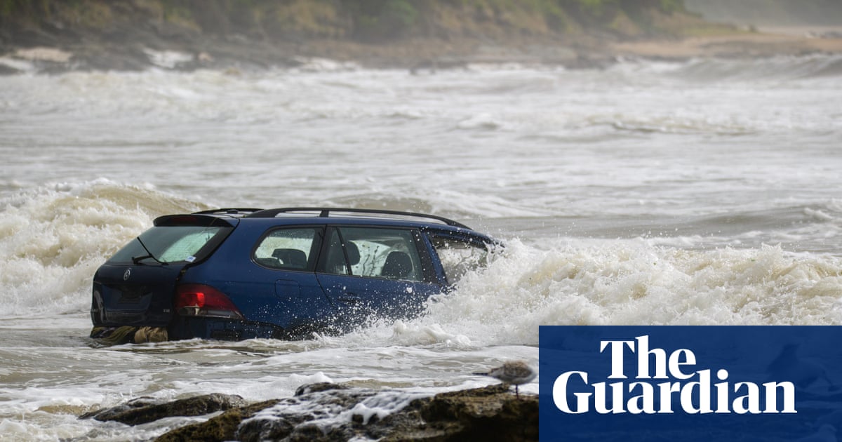
Authorities have defended the timing of warnings for holidaymakers along Victoria’s surf coast who were hit by an “unprecedented” downpour on Thursday, as flash-flooding warnings are now being issued for the NSW south coast.
It comes as Victoria continues to battle major bushfires, with the number of homes destroyed now standing at 289.
About 20 cars were washed into the ocean and campgrounds flooded at Wye River on the coast on Thursday, Victoria’s emergency management commissioner Tim Wiebusch said, after the region received 180mm of rain causing flash-flooding of the Wye, Kennett and Cumberland rivers.
About 600 people, including those staying in the caravan park, were temporarily displaced, with 60 requiring emergency accommodation in Apollo Bay and Lorne on Thursday evening.
Sign up: AU Breaking News email
Colac mayor Jason Schram criticised the level of warnings given to holidaymakers, saying: “The big question I’ve got to those in charge is, how could they not predict 180 [millimetres] of rainfall in that catchment?”
“It’s pretty messy, with mud, debris and, of course, everyone’s personal belongings, caravans, camping gear,” he told Guardian Australia.
People collect their belongings from a caravan park after flash flooding washed them away. Photograph: Michael Currie/AAP
Dharni Giri, spokesperson for Victoria’s emergency management authority, the State Control Centre, said the Wye River and Lorne were hit by “an unprecedented weather event”.
“We got over 180 millimetres of rain in just a six-hour period. Because of the terrain where the rain fell, it accelerates the water flows down through the river systems coming off of Mount Cowley,” she said.
About 186.2mm fell in the 24 hours to 9am, the highest rainfall recorded in one day at Lorne, exceeding the previous record of 123.2mm on 30 September 2021. Up to 100mm of rain was recorded broadly across the Otway coastal fringe
Giri said more than 10,000 people in the area received a text alert telling them to go to higher ground, “so, in our eyes, warnings were not issued late”.
“It was an unprecedented weather event, and our response was pretty incredible when you think about how quickly it happened and how quickly we were able to mobilise SES crews, the local CF brigade, and other emergency partners,” she said.
Bureau of Meteorology (BoM) forecaster, Diana Eadie, told reporters at a press conference on Friday that it had been an “extraordinary” rainfall event and warnings were escalated as the bureau started to see “increased rainfall rates”.
She said a severe thunderstorm warning for heavy rainfall that may lead to flash flooding was first issued at 11.57am, after 45mm of rain was recorded in one hour at Mount Cowley, in the Otway ranges near Lorne. Then, at 12.40am, the warning was escalated to include intense rainfall with the risk of flash flooding over the Surf Coast as the rainfall observations continued to climb rapidly at Mt Cowley.
The clean up along the Victorian surf coast begins. Photograph: Michael Currie/AAP
Speaking at the same press conference, Wiebusch said the situation occurred “very dynamically” and he believed the warnings were “adequate … and as timely as they could be”.
He said the first triple zero call reporting flash flooding was at 1.08pm, and at1.20pm for cars being washed away – around 30 minutes after the BoM upgraded its emergency warning.
There was just one injury, Wiebusch said – a child who climbed on to a roof and had to be airlifted to hospital. Victoria Police also airlifted a man in his 60s from the roof of a shed at Cumberland river, and rescued five hikers and two four-wheel drives bogged west of Lorne.
New South Wales was also hard hit, with the state’s SES responding to more than 274 incidents statewide in the 24 hours to 3pm on Friday – the majority on the South Coast.
In Eden around 40 vehicles were trapped on the Princes Highway for three hours due to water over the road and a fallen tree, and more than 100 people were temporarily stranded at a golf club when surrounding areas flooded.
Earlier, senior meteorologist at the Australian Bureau of Meteorology, Angus Hines, said there would be more flash flooding across the southern parts of NSW and Victoria in coming days, with isolated falls of up to 200mm in three days possible with storms.
“There is a severe weather warning for Friday,” Hines said. “We can see it extends from Wollongong down to the Victorian border, covering the South Coast area and parts of the Illawarra in this region.
The floods carried tents, camping equipment and campers’ personal possessions on to the beach and into the sea. Photograph: Michael Currie/EPA
“We’ll likely see some damaging wind gusts on Friday, up to about 100km an hour. We will also see some heavy, persistent rain.”
The Illawarra and south coast of NSW could receive between 150 and 200mm of rain between Thursday afternoon and Saturday night, Hines said, with “significant” flash flooding.
“There’s likely to be disruption and delays to travel and transport, including road closures,” he said. “It’s going to be very rough on the coastline for boats and maybe even have an impact on flights and travel.”
Flash flooding was so strong it washed cars into the sea. Photograph: Michael Currie/AAP
Severe winds are expected to make it difficult to fight the bushfires in Victoria.
Wiebusch said there continued to be around 10 major fires burning across the state, including in the Otways and Gippsland and the large Longwood fire complex, although none were at emergency warning level.
He said updated assessments found more than 1,000 structures had been damaged or destroyed by the fires, including 289 homes.
Just under 100 roads were still shut and being cleared due to fires and floods, including the road from Skenes Creek to Lorne.
Hundreds of stranded holidaymakers were evacuated from flooded campgrounds. Photograph: Michael Currie/AAP
The climate crisis is making the country more vulnerable to extreme and unpredictable weather and natural disasters, a report from the Insurance Council of Australia warned in October. This week, the World Meteorological Organisation (WMO) said 2025 had continued a three-year streak of “extraordinary global temperatures” during which surface air temperatures averaged 1.48C above preindustrial levels.
Signup link text (KEEP IN SUBSCRIPT FONT and place in top third to half, not in bold)