
Emesent is known for its ability to autonomously map inaccessible spaces. Image: Emesent.
Emesent’s Hovermap provides fast, accurate 3D reality capture for industrial inspection and maintenance.
Emesent has been illuminating the mining maintenance process for nearly a decade. The Queensland-based software company’s flagship product is Hovermap, an artificial intelligence (AI)-powered mobile scanning unit that combines collision-avoidance and autonomous-flight technologies to map underground environments.
Founded by tech trailblazers Farid Kendoul and Stefan Hrabar, who previously worked together at CSIRO, Emesent has quickly become a standard-bearer in underground mapping solutions. The Hovermap technology is the result of combining two breakthroughs: simultaneous localisation and mapping (SLAM) software, and light detection and ranging (LiDAR) capture and analysis.
The scanning unit’s versatility allows it to be mounted to a drone for aerial views, switched to a walking scan for congested equipment areas, attached to a vehicle for vast spaces, or lowered into deep shafts via a protective cage when access is particularly unsafe.
This type of deployment flexibility has helped the Hovermap earn a reputation as the “Swiss Army Knife” of mobile survey mapping and maintenance.
“We’re giving operators more confidence by enabling Hovermap to fly autonomously through even narrower spaces,” Hrabar said. “Improvements in Hovermap’s perception technology allow drones to pass through gaps as small as 2.4m without human intervention.”
This is aided by Emesent’s AI-powered autonomous mission control software, Cortex, which is accessed via the company’s app, Commander.
The software analyses the environment to detect obstacles and plan optimal routes in real-time, requiring less human intervention in maintenance.
“Our ongoing developments in Cortex and Commander represent the biggest advancement in our autonomous mapping solution in years,” Hrabar said
“This enables autonomous exploration-based data capture, delivers unparalleled simplicity of use, further increases operational safety, and allows capturing data in previously inaccessible areas.”
“Hovermap is our only option”
The Northparkes, New South Wales, site of the China Molybdenum Company (CMOC) mine utilised Emesent’s Hovermap to monitor essential underground infrastructure following the partial failure of two new 560m ventilation shafts shortly after completion. The mine needed detailed data, which its existing downhole bore camera could not provide.
“Access to the ventilation shafts was not possible by any other means,” CMOC Northparkes Mines senior operations geotechnical engineer Linda Snyman said.
“Scanning with Hovermap is our only option for obtaining detailed information about what’s happening down there.”
The solution involved safely lowering the Hovermap LiDAR scanner, mounted in a protective cage, 560m down the intake shaft on a cable. The scan took about two hours to complete.
By comparing scans from a year apart, Northparkes personnel were able to measure changes in shaft overbreak and deformation over time and identify the maintenance and work needed.
This analysis identified rock features such as joints and fractures that could affect the stability of the ventilation incline. Access to accurate data enabled the team to take timely remedial action, significantly reducing the likelihood of costly mine shutdowns and production losses.
Hovermap is continuously used across the mine to monitor other assets, such as drifts and surface stockpiles.
“Hours rather than days”
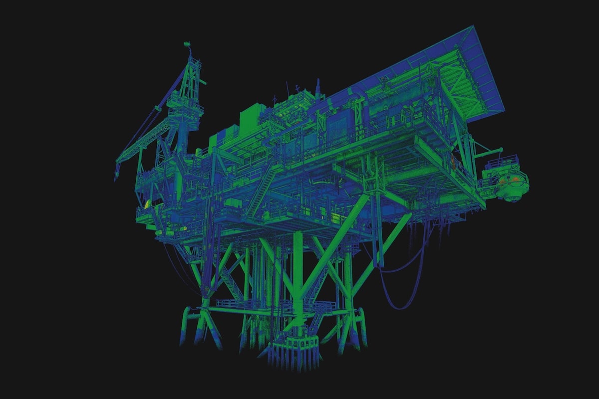
Aerial Production Services (APS) chose Emesent to create a 3D digital twin of a large, complex onshore natural gas compressor station in the south-eastern US. The facility contains extensive equipment, including vessels, piping and a compressor skid, requiring accurate scanning above, below and between the equipment.
Hovermap’s LiDAR system was mounted to a drone and utilised pilot assist mode to maintain a safe standoff distance from the in-service equipment. APS completed the scan in just two 25-minute flights, which reduced the inspection time by more than 80 per cent compared to a typical ground LiDAR scan that would have totalled approximately six-and-a-half hours without capturing detail at height.
“The Hovermap unit allowed us to capture data with a depth of detail that we couldn’t achieve before, and to do so in hours rather than days,” APS field operation manager, oil and gas team Drew Talley said. “Terrestrial measuring tools would have provided some footprints but being able to fly above and below the equipment gave us a thorough representation.”
APS also performed a walking scan to enhance data in heavily congested spots. The resulting 3D digital twin will be used by the asset owner to support future maintenance, operations and construction planning, and provide dimensional data for new equipment design. This single, versatile tool significantly cut post-scan processing time by more than 40 per cent, the company said.
The APS project highlights Hovermap’s dynamic and versatile uses, but Hrabar said the mining industry is where the technology made its name and will endeavour to continue to innovate.
“Emesent is known for its ability to autonomously map inaccessible spaces, especially dangerous underground environments like stopes,” Hrabar said.
“What is unique about Hovermap is its ease and speed of deployment in challenging subterranean spaces. It ensures the safety of maintenance teams in the field, helps minimise the inconvenience of monitoring and inspections, and saves both time and the cost of operations.”
This feature appeared in the January-February edition of Safe to Work.