
The Commonwealth Scientific and Industrial Research Organisation (CSIRO) reveals fresh geological insights into one of the Northern Territory’s geophysics features – the Australia magnetic anomaly.
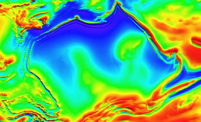
Researchers describe the outline of the anomaly to echo the shape of the Australian coastline and represents an example of how magnetic data can illuminate the unseen world beneath.
CSIRO’s Dr Clive Foss says magnetic data allows researchers to see through the ground and understand geological architecture that would otherwise remain completely hidden.
“By improving how we process and model these datasets, we can extract more geological information than ever before,” Foss says.
Applying advanced analytical techniques to model the area, CSIRO produced a map that could identify the tops of magnetic bodies with unprecedented precision.
Together, these insights provide a much clearer understanding of the region’s structural evolution, hinting at the pathways that may have influenced mineral systems over geological time.

Australia’s anomaly
CSIRO reports the anomaly was imaged using regional aeromagnetic data collected during the Northern Territory Government’s Bonney Well survey. The open-access dataset, curated by Geoscience Australia in a national geoscience database, provided the foundation for CSIRO’s advanced modelling of the phenomenon.
Earlier maps of the region were hampered by artefacts – visual distortions that blurred important details, particularly where magnetic structure aligned closely to fightlines, as reported by CSIRO.
An innovative gridding algorithm refined CSIRO’s dataset and produced cleaner, more consistent images.
With the improved clarity, CSIRO was able to uncover features long hidden from view, including distinct geological boundaries, subtle magnetic layers, and magnetic signatures revealing the shapes and orientations of buried structures.
CSIRO reports that most of the Australia anomaly is buried, but parts of its western margin host rare windows into the past through outcrops of the paleoproterozoic Hatches Creek Formation.
The rocks tell a story of sandstones forming ridges and elevated terrain, interspersed with volcanic layers rich in magnetic minerals. The sandstones were laid down in shallow seas and river deltas, while the volcanic material originated from eruptions through fissures and vents over 1.5 billion years ago, according to the organisation.
Over time, the formations folded, refolded and reshaped – leaving a deep and complex geological tapestry that the new magnetic models have begun to unravel.
Write to Aaliyah Rogan at Mining.com.au
Images: CSIRO