
Heavy spells of rain and storms look set to saturate much of Australia’s east coast over the start of the week.
Sky News Weather Meteorologist Tamsin Green explained while showers and storms had already rolled through much of the country, there was yet “more rain on the way”.
“It’s an improving picture from what we’ll have seen through Sunday in the clearance of that cold front, but still some showers or thunderstorms will be lingering across the south-east,” she said.
In Queensland, a tropical low drawing in a lot of moisture would drive “heavy spells of rain” on Monday for the interior of the state.
The slow-moving system will also pose a “severe” thunderstorm threat, particularly across the west of Queensland.
“Showers and thunderstorms are more well-scattered across the north and the best chance of fine weather across the south-east once again, where Brisbane will be seeing highs of 30C, just the chance of a few showers blowing in on that onshore breeze,” Green said.
In New South Wales, there is a possibility of “lingering showers and thunderstorms”, particularly in the east and south-east regions, including Sydney, the Illawarra and stretching out to the Blue Mountains.
During the morning, the “greatest threat” was across the west of the state where severe thunderstorms and heavy downpours can be expected.
In Victoria, isolated showers and thunderstorms are forecast to clear through the morning and will generally affect the central and eastern portions of the state, along with cool temperatures.
Tasmania is also expected to see an “improving picture” after a Sunday of windy weather and rain.
“Down to Tasmania, another cooler day expected here as well, with temperatures generally in the low-20s… a good deal of settled weather and generally an improving picture as the afternoon wears on,” Green said.
Meanwhile, in South Australia some “isolated thunderstorms” are set to skim across the far north and north-east pastoral districts, but elsewhere conditions are expected to be “fine and settled”.
Many Western Australians can also expect fine weather, but towards the interior of the state, around the Gascoigne, Pilbara and Kimberley regions, there is the threat of “some gusty thunderstorms”.
In the Northern Territory, a flood risk looms for Alice Springs as a “very slow moving tropical low” looks set to drive heavy falls across the Top End.
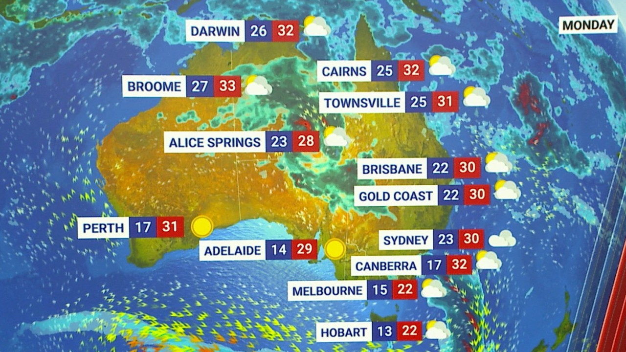
Across the national capitals on Monday, Sydneysiders can expect a high of 30C and a low of 23C.
Melbournians are in for a cool 15C low and a high of 22C.
Brisbane is set to be warm despite the chance of rain, with a max of 30C and a minimum of 22C.
Perth is in for a high of 31C and low of 17C, while Adelaide is also set for a warm 29C day, with a low of 14C.
Hobart is looking at a 22C high and a low of 13C.
Canberra and Darwin are both in for highs of 32C, but residents in the former can expect a low of 17C, while those in the latter will see a milder low of 26C.