
THERE’S been more heavy rainfall across parts of northern Australia over the past few days, with more moderate falls across inland areas and parts of the south.
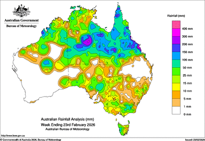
As seen in this seven-day rainfall map produced by BOM to 9am this morning, slow-moving troughs and tropical lows brought showers, rain and thunderstorms across large parts of northern Australia.
A band of low pressure in northern Queensland pulled in offshore moisture and triggered moderate to heavy rain around the state’s northwest and into the Gulf and Peninsula regions.
Biggest falls above 200mm for the week were received in the Tennant Creek region and nearby Barkly Tableland in the Northern Territory. To the east, patchy falls of 100mm and more have been reported around Longreach north to Cloncurry, and intensifying further south.
Queensland’s central coast and adjacent inland also recorded falls of 50-200 mm.
There is isolated major flooding in parts of northern, western, and central Queensland, with ongoing minor to moderate flooding, in other regions. There are major flood warnings for the Flinders and Cape Rivers in North Queensland, with moderate flood warnings for the Western, Bulloo, Georgina and Thomson Rivers in the Channels, and Isaac River in Central Queensland.
There is a flood watch for parts of the Gulf of Carpentaria and Cape York Peninsula, with BOM warning flooding is likely to continue in coming days.
Two cold fronts and associated troughs crossed the south-east, drawing in tropical moisture and producing rain, showers and isolated thunderstorms, BOM said.
Further south, parts of eastern Victoria and areas north of the Spencer Gulf in South Australia received falls of 50-100mm for the week.
The East-West rail corridor linking Western Australia to the eastern states is closed, after flooding caused rail damage. Its expected the line will be closed for at least a week.
Meanwhile BOM warns that a tropical low is sitting over the south-eastern part of the Northern Territory, bringing the risk of further heavy rainfall to the North West and Channel Country.
“The worst of it is just over the border in the Northern Territory with a low spinning away there and giving some heavy to locally intense rainfall,” a senior meteorologist said.
Some forecasts have prospects for up to 500mm over the next 24 hours.