
Another burst of tropical moisture and heavy rain will descend through the heart of Australia during the coming days.
But while outback communities brace for potential flooding, the system offers hope of delivering further drought relief for southern farmers.
And despite a dry outlook for the remainder of autumn, March is now on track to become one of Australia’s wettest on record — continuing the remarkable green transformation across the interior as rivers and lakes fill to some of the highest levels this century.
Loading…A year’s rain in 72 hours
The past week has delivered torrential rain and major flooding to Queensland and the Top End, and it is still bucketing down along the Northern Territory-Kimberely border near a low.
While the tropical low will not follow its predecessor from a fortnight ago and dive into the outback, the system will help draw a very moist northerly airstream and rain deep well south through the weekend.
According to modelling around 50 to 100 millimetres should fall during the next 48 hours across the western half of the NT and adjacent parts of Western Australia, although the Bureau of Meteorology’s (BOM) flood watch is warning of isolated totals closer to 200mm.
The heaviest rain should then cross the border into South Australia on Monday, and produce 48-hour totals of around 30 to 60mm north of about Roxby Downs, but with pockets closer to 100mm.
For northern SA, the most arid region of Australia, this would represent a large slice of the annual mean rainfall which only ranges from around 150 to 200mm.
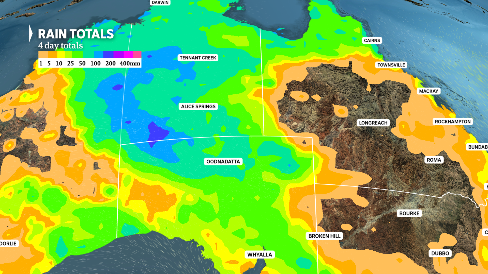
An average of 50 to 100mm should soak much of the NT and northern SA over the next four days. (ABC News)
To put the expected falls into historical perspective, the town of Coober Pedy averages just 12mm in March, and a total in excess of 66mm from this event would make this March the wettest in nearly four decades.
The climate is a touch wetter to the north with Yulara, near Uluru, and Alice Springs, averaging 33mm in March, although the Alice has already picked up well over 200mm this year.
Follow up drought relief for southern farmers
This weekend’s weather could be best described as uneventful for south-east states — dry with near average temperatures.
However, the intrusion of tropical air will reach southern Australia on Monday and link with a passing trough to deliver a band of patchy rain across agricultural SA, Victoria and southern New South Wales.
Early indications show only light rain averaging 1 to 10mm across southern SA and south-west Victoria, with moderate totals closer to 20mm possible further east into late Monday and Tuesday.
The exact location of the heaviest falls is difficult to forecast, since the band should be relatively thin, a property which allows a slight north-south shift to result in the difference between useful falls and nothing for any given location.
Below is the European Centre for Medium-Range Weather Forecast model’s current prediction for the event which has the higher 20mm totals roughly aligning with the Murray River, although other models are tipping central Victoria will receive the best falls.
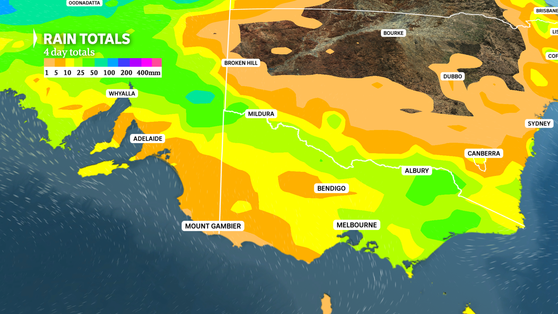
A thin band of 10 to 20mm of rain is likely through Monday and Tuesday over southern inland Australia. (ABC: News)
A drier air mass from the south arriving midweek will then flush moisture and rain back north, contracting to areas north and west of Alice Springs by Thursday.
While it has been an unexpectedly wet start to autumn for southern states, long-range outlooks still strongly favour below average falls through the remainder of 2026.
The unfavourable predictions are partly due to the expected development of El Niño, making any rainfall which does fall during the coming weeks and months even more critical since significant deficits could accumulate through winter and spring.
Outback primed for floods as Kati Thanda-Lake Eyre rises
With the ground already saturated or wet following hundreds of millimetres a few weeks ago, much of the water will run-off into creeks and rivers, as opposed to sinking into the ground.
And considering many streams are already flowing, the rain will trigger a rapid spike in water levels, while for flatter regions, water will pond and lead to widespread inundation of normally dry ground.
This has prompted the BOM to issue a flood watch for more than two dozen inland catchments, warning of prolonged overland flooding and the potential for communities and homesteads to become isolated for an extended period, with many outback roads already closed due to damage or flooding from the previous event.
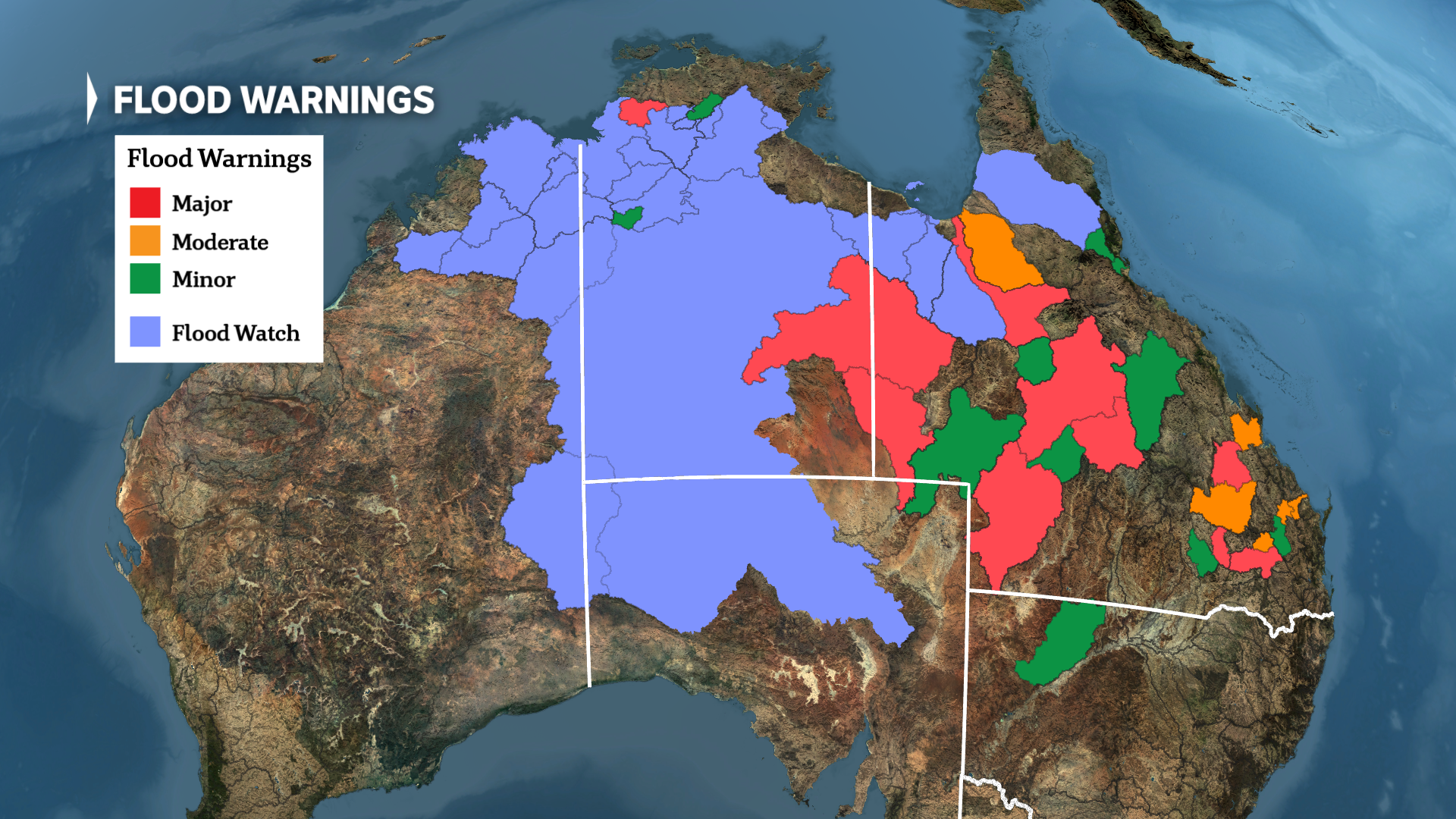
Flood warnings are current for dozens of Queensland rivers, and a renewed flood watch is now in force for much of the outback. (ABC News)
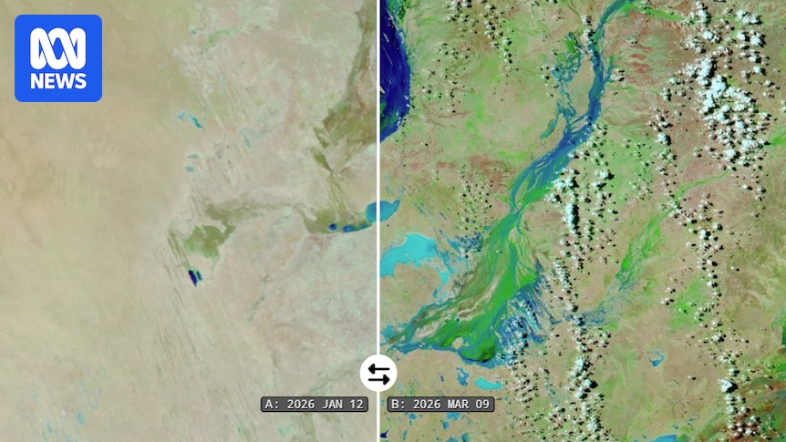
For Kati Thanda-Lake Eyre, Australia’s largest lake, the depth of water reported by the Yacht Club earlier this week at Belt Bay, the deepest section, was 1.9 metres and rising.
Although there is no official records of the lake’s water depths, according to tourist operators and locals the 2025 peak was near 2.1 to 2.2 metres, which is near the 2010 level.
However, this year’s flooding is different because the majority of the water is arriving from local tributaries as opposed to most events which require river flows through Queensland’s Channel Country.
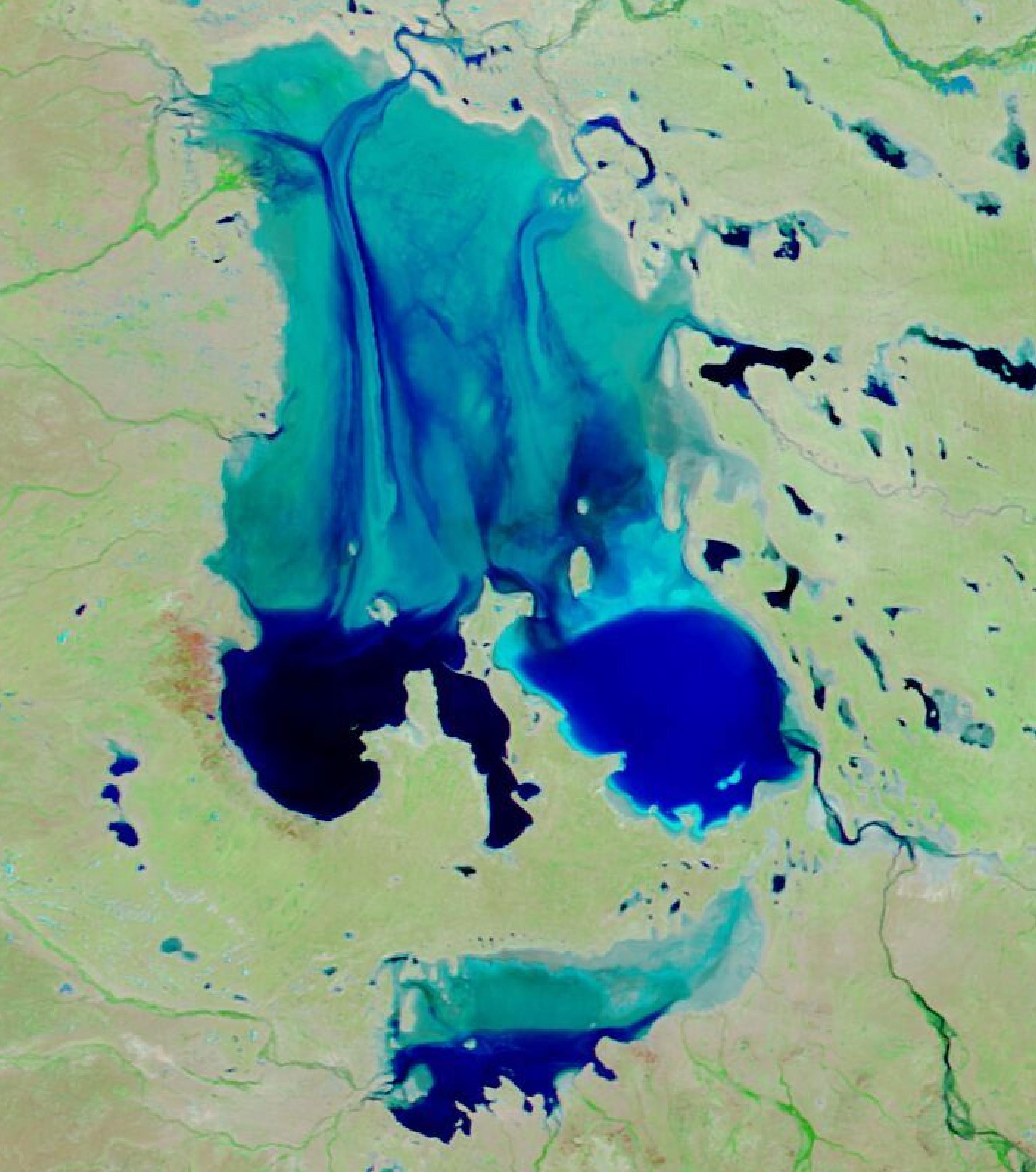
A NASA satellite image from this week shows the Kati Thanda-Lake Eyre region is brimming with water following recent heavy rain. (Supplied)
Historical river height data for most of SA is unavailable, making a prediction extremely difficult, especially since upcoming rain will boost inflows even further, but the highest lake level this century is certainly a possibility which would mean the greatest flood event since 1990 or 1984.
However, despite some hype surrounding a possible repeat of the record 6 metre peak from 1974, that outcome would most likely require a tropical low of cyclone to impact the upper Lake Eyre Basin in western Queensland before the end of the wet season.