
For the first time in 21 years, a tropical cyclone could make three separate landfalls on the Australian mainland, carving out a 3,000-kilometre-long path of destructive winds and flooding.
The system, Narelle, is deepening in the northern Coral Sea and should strike the Cape York Peninsula late tomorrow or Friday, then the Northern Territory over the weekend, and possibly Western Australia next week.
The last Australian triple landfall system was Severe Tropical Cyclone Ingrid in March 2005, which took a similar track west from north Queensland to WA.
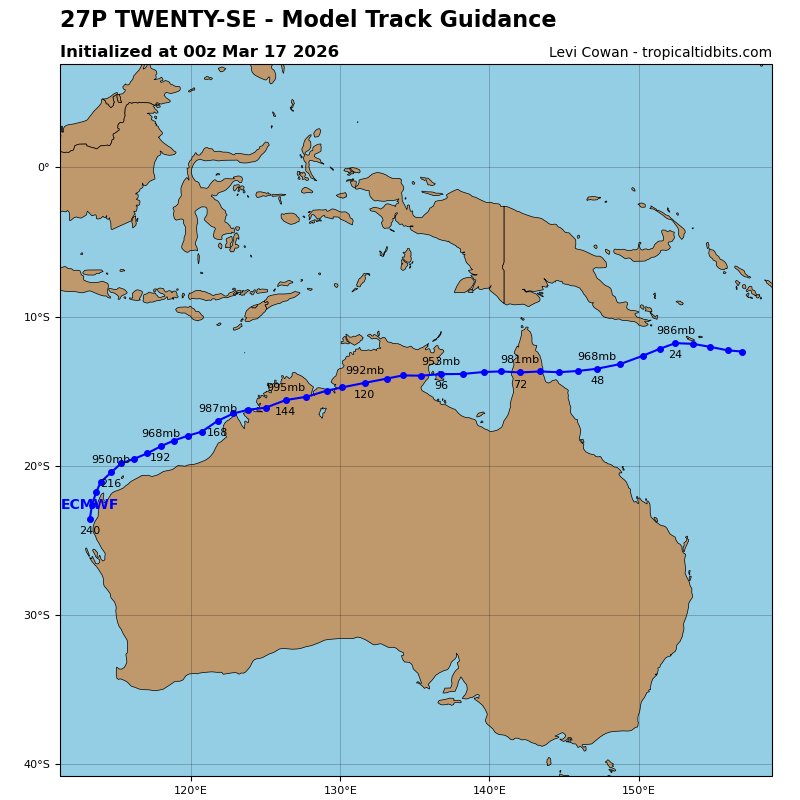
The ECMWF model forecast issued yesterday for the future path of Cyclone Narelle has the system making three landfalls. (Supplied)
Queensland’s first cyclone of the season imminent
Most corners of Queensland have been hammered in recent months by multiple rain and flood events, but so far this wet season, the state has escaped without a direct impact from a tropical cyclone.
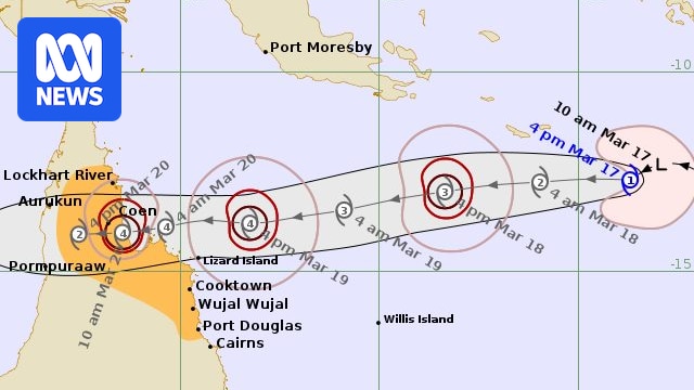
But that’s almost guaranteed to change this week as Cyclone Narelle, currently about 1,000km offshore, hastily approaches Cape York Peninsula from the east.
And the system is brewing in a relatively favourable environment for further intensification, including water temperatures in the northern Coral Sea about 29 to 30 degrees Celsius, well above the minimum threshold for cyclones of 26.5C.
Also aiding development is a deep layer of moisture, unstable atmosphere, and lack of wind shear — a combination that should ensure Narelle becomes a severe category three or above cyclone before reaching Far North Queensland.
The most likely target for a direct impact is the coastal stretch from about Cooktown to Lockhart River, and immediately surrounding the eye conditions will be extremely dangerous, with peak wind gusts potentially near 200 kilometres an hour, and rain rates exceeding 100 millimetres in 6 hours and 200mm in 24 hours.

While a circulation of heavy rain spins over Cape York Peninsula, a second region on flooding is likely on the North Tropical Coast south of Narelle. (ABC News)
But thankfully, while Narelle’s core should be intense and destructive, by cyclone standards, the storm is small, with a radius of gales extending only about 100 to 150km from the centre.
Along with a speedy forward movement of about 20km/h, the modest scale should restrict cyclonic conditions, including heavy rain, to around 10 hours — so while flooding is likely over Cape York Peninsula, the system won’t hang around long enough for record or widespread major floods.
The more populated North Tropical Coast, including Cairns, should escape a direct hit and even a cyclone warning; however, the outer bands of Narelle will interact with moist winds off the Coral Sea to generate a secondary region of heavy rain and flooding as far down the coast as Ingham.
Narelle to re-emerge in the Gulf
The forecast path for Narelle is far more certain than most cyclones due to the surrounding environment — a firm ridge of high pressure over the Australian mainland has created a wide belt of easterly winds over the tropics, which will steer the system in a near-straight line towards the west.
After crossing Cape York Peninsula, Narelle should re-emerge over the Gulf of Carpentaria only about 12 hours after initial landfall.
The predictable movement will then send the storm rapidly across the Gulf into the weekend, and with conditions favourable for re-intensification, a second severe coastal impact is likely on the Top End’s east coast.
The structure and nature of this next landfall look similar to the first — a quick burst of destructive winds and flooding rain, but thankfully, the sparse population of the north-east NT should limit damage.
Now back over land, Narelle will commence weakening for a second time, but still spread a thin band of heavy rain and gales across the inland Top End, and unfortunately, some towns recently devastated by floods, including Katherine, could see another round of flooding.

A thin trail of 100 to 300mm of rain will follow under the long westward path of Cyclone Narelle this week. (ABC News)
Despite Narelle being a relatively predictable system, by the time it reaches WA longitudes, the system’s path and timing become less clear.
It’s possible the low will head off the western Top End coast over the Timor Sea or perhaps remain inland and enter the Kimberley.
Either way, before exiting the NT, anytime from about Sunday to Tuesday, demotion is likely to a tropical low, the Kimberley can still expect flooding rain totals of 100 to 300mm near the centre of the low.
Rare third coastal impact next week
The journey Cyclone Narelle will take after leaving the Kimberley next week remains a mystery.
While announcing a cyclone’s detailed track a week in advance would be foolish, there are two scenarios that could be considered plausible.
The first is a continuation west out into the Indian Ocean and away from WA.
The second, as shown in the animation above, is a gradual left-hand turn towards the Pilbara coast, and a third coastal impact — potentially again as a category three or above, and possibly as a much larger system with a wider field of gales and heavy rain.
Since 1980, only two tropical cyclones have managed three coastal crossings, which impacted Queensland, the NT and WA.
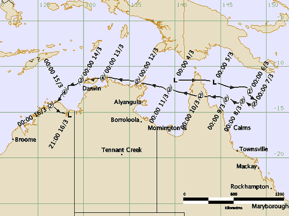
The path of Severe Tropical Cyclone Ingrid from March 2005. (Supplied: Bureau of Meteorology)
The last system to do so was Cyclone Ingrid in 2005, which struck the Cape York Peninsula on March 10, then the Coburg Peninsula in the NT on March 13, and finally the Kimberley coast two days later.
The other was Cyclone Steve in 2000, but Ingrid is the only system that was a category three or above during all landfalls, and like Narelle, Ingrid was a small system with a radius of gales not much beyond 100km.